Emporia Topo Map Kansas
To zoom in, hover over the map of Emporia
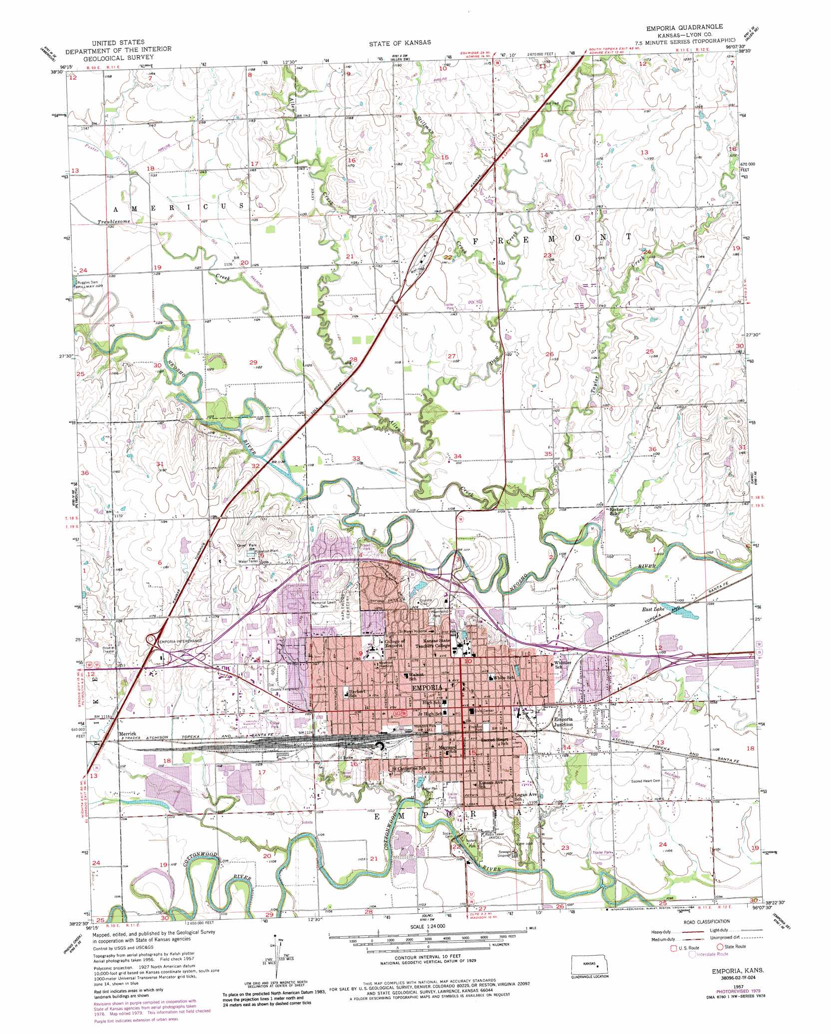
USGS Topo Quad 38096d2 - 1:24,000 scale
| Topo Map Name: | Emporia |
| USGS Topo Quad ID: | 38096d2 |
| Print Size: | ca. 21 1/4" wide x 27" high |
| Southeast Coordinates: | 38.375° N latitude / 96.125° W longitude |
| Map Center Coordinates: | 38.4375° N latitude / 96.1875° W longitude |
| U.S. State: | KS |
| Filename: | o38096d2.jpg |
| Download Map JPG Image: | Emporia topo map 1:24,000 scale |
| Map Type: | Topographic |
| Topo Series: | 7.5´ |
| Map Scale: | 1:24,000 |
| Source of Map Images: | United States Geological Survey (USGS) |
| Alternate Map Versions: |
Emporia KS 1957, updated 1958 Download PDF Buy paper map Emporia KS 1957, updated 1979 Download PDF Buy paper map Emporia KS 1957, updated 1986 Download PDF Buy paper map Emporia KS 2009 Download PDF Buy paper map Emporia KS 2012 Download PDF Buy paper map Emporia KS 2015 Download PDF Buy paper map |
1:24,000 Topo Quads surrounding Emporia
Council Grove |
Bushong |
Allen |
Admire |
Miller |
Lake Kahola |
Americus |
Allen Sw |
Allen Se |
Reading |
Saffordville |
Plymouth |
Emporia |
Lang |
Lebo Nw |
Gladstone |
Phenis Creek |
Olpe |
Emporia Se |
Hartford |
Thrall Nw |
Shaw Creek |
Madison |
Madison Ne |
Gridley Nw |
> Back to 38096a1 at 1:100,000 scale
> Back to 38096a1 at 1:250,000 scale
> Back to U.S. Topo Maps home
Emporia topo map: Gazetteer
Emporia: Areas
Kellogg Circle elevation 355m 1164′Emporia: Bridges
Wooster Bridge elevation 347m 1138′Emporia: Crossings
Emporia Interchange elevation 354m 1161′Emporia: Dams
Ruggles Dam elevation 340m 1115′Soden Dam elevation 329m 1079′
Emporia: Lakes
East Lake elevation 333m 1092′Emporia: Parks
Dryer Park elevation 373m 1223′Emporia Municipal Zoo elevation 339m 1112′
Fremont Park elevation 349m 1145′
Hammond Park elevation 346m 1135′
Humbolt Park elevation 346m 1135′
Jones Youth Recreation Park elevation 348m 1141′
Lakeview Park elevation 347m 1138′
Las Casitas Park elevation 344m 1128′
Lowther Field elevation 342m 1122′
Peter Pan Park elevation 339m 1112′
Quaker Park elevation 346m 1135′
Sertoma Park elevation 346m 1135′
Soden Park elevation 335m 1099′
Southwest Santa Fe Park elevation 344m 1128′
Urbanside Park elevation 348m 1141′
Walnut Park elevation 350m 1148′
Welch Stadium elevation 343m 1125′
Wilson Park elevation 354m 1161′
Woodland Park elevation 344m 1128′
Zola Witten Track elevation 343m 1125′
Emporia: Populated Places
Berkeley Hills elevation 351m 1151′Emporia elevation 348m 1141′
Emporia Junction elevation 345m 1131′
Merrick elevation 341m 1118′
Emporia: Post Offices
Emporia Post Office elevation 348m 1141′Emporia: Reservoirs
Wooster Lake elevation 348m 1141′Emporia: Streams
Allen Creek elevation 334m 1095′Dow Creek elevation 335m 1099′
Pester Creek elevation 347m 1138′
Stillman Creek elevation 340m 1115′
Taylor Creek elevation 337m 1105′
Troublesome Creek elevation 335m 1099′
Emporia digital topo map on disk
Buy this Emporia topo map showing relief, roads, GPS coordinates and other geographical features, as a high-resolution digital map file on DVD: