Sharon Springs 3 Ne Topo Map Kansas
To zoom in, hover over the map of Sharon Springs 3 Ne
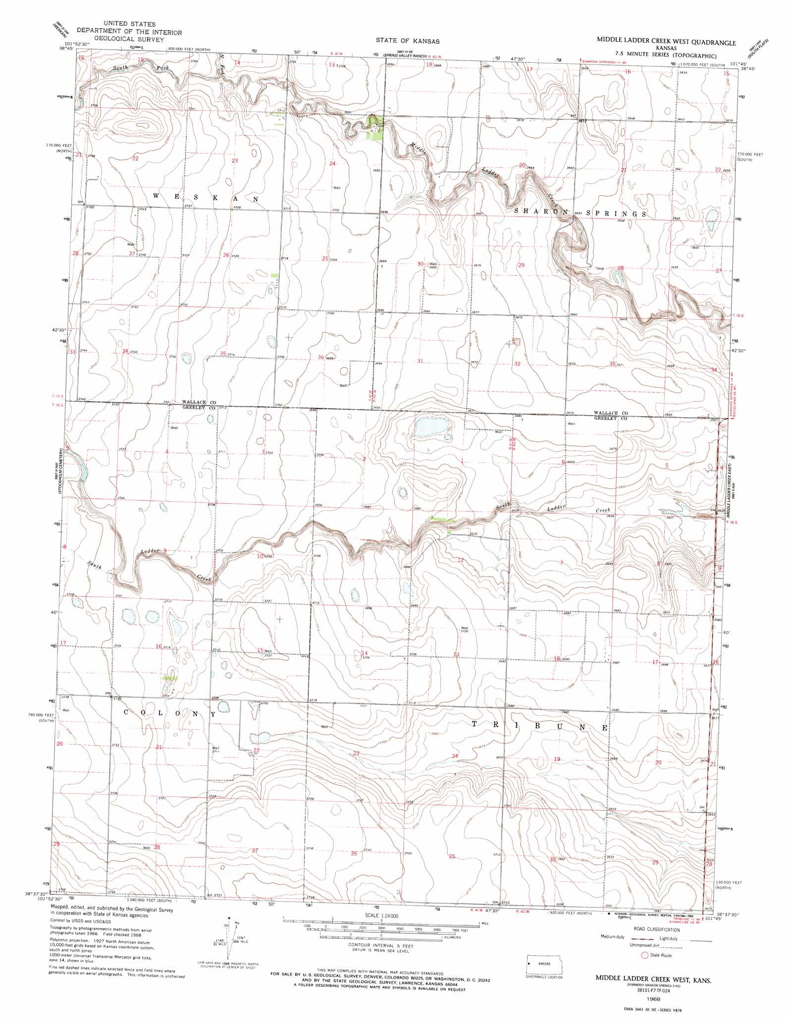
USGS Topo Quad 38101f7 - 1:24,000 scale
| Topo Map Name: | Sharon Springs 3 Ne |
| USGS Topo Quad ID: | 38101f7 |
| Print Size: | ca. 21 1/4" wide x 27" high |
| Southeast Coordinates: | 38.625° N latitude / 101.75° W longitude |
| Map Center Coordinates: | 38.6875° N latitude / 101.8125° W longitude |
| U.S. State: | KS |
| Filename: | o38101f7.jpg |
| Download Map JPG Image: | Sharon Springs 3 Ne topo map 1:24,000 scale |
| Map Type: | Topographic |
| Topo Series: | 7.5´ |
| Map Scale: | 1:24,000 |
| Source of Map Images: | United States Geological Survey (USGS) |
| Alternate Map Versions: |
Sharon Springs 3 NE KS 1968, updated 1969 Download PDF Buy paper map Middle Ladder Creek West KS 1968, updated 1993 Download PDF Buy paper map Middle Ladder Creek West KS 2010 Download PDF Buy paper map Middle Ladder Creek West KS 2012 Download PDF Buy paper map Middle Ladder Creek West KS 2016 Download PDF Buy paper map |
1:24,000 Topo Quads surrounding Sharon Springs 3 Ne
Arapahoe Ne |
Weskan Nw |
Sharon Springs West |
Sharon Springs East |
Wallace |
Arapahoe Se |
Weskan |
Spring Valley Ranch |
South Flats |
Harrison Flats |
Cheyenne Wells 4 Ne |
Sharon Springs 3 Nw |
Sharon Springs 3 Ne |
Sharon Springs 4 Nw |
Sharon Springs 4 Ne |
Cheyenne Wells 4 Se |
Sharon Springs 3 Sw |
Sharon Springs 3 Se |
Sharon Springs 4 Sw |
Sharon Springs 4 Se |
Towner |
Tribune Nw |
Tribune |
Selkirk Nw |
Selkirk |
> Back to 38101e1 at 1:100,000 scale
> Back to 38100a1 at 1:250,000 scale
> Back to U.S. Topo Maps home
Sharon Springs 3 Ne topo map: Gazetteer
Sharon Springs 3 Ne: Airports
Walter Airport elevation 1135m 3723′Sharon Springs 3 Ne: Streams
North Fork Middle Ladder Creek elevation 1127m 3697′South Fork Middle Ladder Creek elevation 1127m 3697′
Sharon Springs 3 Ne digital topo map on disk
Buy this Sharon Springs 3 Ne topo map showing relief, roads, GPS coordinates and other geographical features, as a high-resolution digital map file on DVD: