Mcintosh Ranch Topo Map Colorado
To zoom in, hover over the map of Mcintosh Ranch
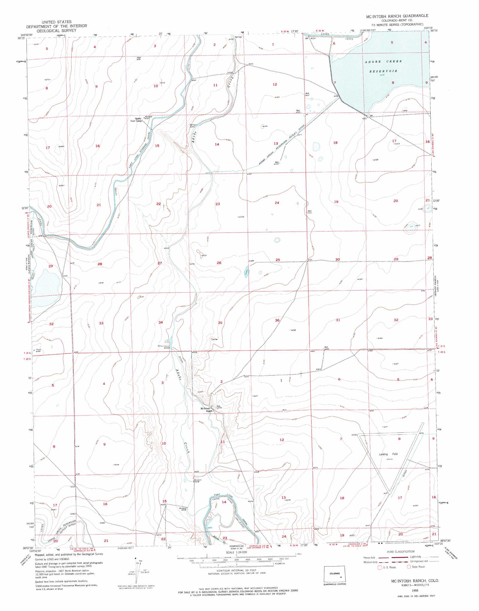
USGS Topo Quad 38103b3 - 1:24,000 scale
| Topo Map Name: | Mcintosh Ranch |
| USGS Topo Quad ID: | 38103b3 |
| Print Size: | ca. 21 1/4" wide x 27" high |
| Southeast Coordinates: | 38.125° N latitude / 103.25° W longitude |
| Map Center Coordinates: | 38.1875° N latitude / 103.3125° W longitude |
| U.S. State: | CO |
| Filename: | o38103b3.jpg |
| Download Map JPG Image: | Mcintosh Ranch topo map 1:24,000 scale |
| Map Type: | Topographic |
| Topo Series: | 7.5´ |
| Map Scale: | 1:24,000 |
| Source of Map Images: | United States Geological Survey (USGS) |
| Alternate Map Versions: |
Mc Intosh Ranch CO 1955, updated 1956 Download PDF Buy paper map Mc Intosh Ranch CO 1955, updated 1975 Download PDF Buy paper map McIntosh Ranch CO 2010 Download PDF Buy paper map McIntosh Ranch CO 2013 Download PDF Buy paper map McIntosh Ranch CO 2016 Download PDF Buy paper map |
1:24,000 Topo Quads surrounding Mcintosh Ranch
The Pinnacles |
Trimble Lake |
Arlington Ne |
Haswell |
Haswell Ne |
Todd Point |
Houston Lakes |
Arlington |
Long Lake |
Haswell Se |
Meredith Hill |
Lewis Ranch |
Mcintosh Ranch |
Bishop Ranch |
Tree Top Ranch |
Cheraw |
Hadley |
Cornelia |
Las Animas |
Kreybill |
La Junta |
Thompson Arroyo |
Hackamore Ranch |
Gilpin |
Toonerville Ne |
> Back to 38103a1 at 1:100,000 scale
> Back to 38102a1 at 1:250,000 scale
> Back to U.S. Topo Maps home
Mcintosh Ranch topo map: Gazetteer
Mcintosh Ranch: Canals
Adobe Creek Reservoir Outlet Ditch elevation 1253m 4110′Horse Creek Reservoir Inlet Ditch elevation 1253m 4110′
Horse Creek Reservoir Outlet Ditch elevation 1242m 4074′
Mcintosh Ranch: Dams
Adobe Creek Dam elevation 1257m 4124′Mcintosh Ranch: Reservoirs
Adobe Creek Reservoir elevation 1258m 4127′Blue Lake Reservoir elevation 1257m 4124′
Mcintosh Ranch digital topo map on disk
Buy this Mcintosh Ranch topo map showing relief, roads, GPS coordinates and other geographical features, as a high-resolution digital map file on DVD: