Southeast Pueblo Topo Map Colorado
To zoom in, hover over the map of Southeast Pueblo
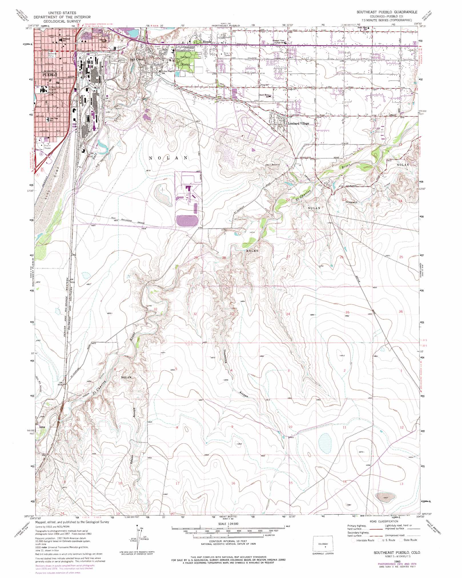
USGS Topo Quad 38104b5 - 1:24,000 scale
| Topo Map Name: | Southeast Pueblo |
| USGS Topo Quad ID: | 38104b5 |
| Print Size: | ca. 21 1/4" wide x 27" high |
| Southeast Coordinates: | 38.125° N latitude / 104.5° W longitude |
| Map Center Coordinates: | 38.1875° N latitude / 104.5625° W longitude |
| U.S. State: | CO |
| Filename: | o38104b5.jpg |
| Download Map JPG Image: | Southeast Pueblo topo map 1:24,000 scale |
| Map Type: | Topographic |
| Topo Series: | 7.5´ |
| Map Scale: | 1:24,000 |
| Source of Map Images: | United States Geological Survey (USGS) |
| Alternate Map Versions: |
Southeast Pueblo CO 1960, updated 1963 Download PDF Buy paper map Southeast Pueblo CO 1960, updated 1966 Download PDF Buy paper map Southeast Pueblo CO 1960, updated 1966 Download PDF Buy paper map Southeast Pueblo CO 1960, updated 1972 Download PDF Buy paper map Southeast Pueblo CO 1960, updated 1977 Download PDF Buy paper map Southeast Pueblo CO 2010 Download PDF Buy paper map Southeast Pueblo CO 2013 Download PDF Buy paper map Southeast Pueblo CO 2016 Download PDF Buy paper map |
1:24,000 Topo Quads surrounding Southeast Pueblo
Stone City |
Steele Hollow |
Pinon |
Bar J H Ranch |
North Avondale Ne |
Swallows |
Northwest Pueblo |
Northeast Pueblo |
Devine |
North Avondale |
Beulah Ne |
Southwest Pueblo |
Southeast Pueblo |
Vineland |
Avondale |
Muldoon Hill |
Verde School |
Goat Butte |
Doyle Bridge |
Chicos Well |
Colorado City |
Graneros Flats |
Cedarwood |
Hog Ranch Canyon |
Red Top Ranch |
> Back to 38104a1 at 1:100,000 scale
> Back to 38104a1 at 1:250,000 scale
> Back to U.S. Topo Maps home
Southeast Pueblo topo map: Gazetteer
Southeast Pueblo: Airports
Saint Mary-Corwin Hospital Heliport elevation 1462m 4796′Southeast Pueblo: Canals
Bessemer Ditch elevation 1453m 4767′Southeast Pueblo: Dams
Comanche Dam elevation 1460m 4790′North Mills Clarifying Dam elevation 1415m 4642′
Saint Charles Mesa Dam elevation 1453m 4767′
Saint Charles Mesa Number 2 Dam elevation 1419m 4655′
Southeast Pueblo: Parks
Bessemer Park elevation 1454m 4770′Southeast Pueblo: Populated Places
Blende elevation 1444m 4737′Lombard Village elevation 1464m 4803′
Saint Charles elevation 1513m 4963′
Salt Creek elevation 1448m 4750′
Southeast Pueblo: Reservoirs
Comanche Reservoir elevation 1460m 4790′Lake Minnequa elevation 1462m 4796′
North Mills Clarifying Pond elevation 1415m 4642′
Saint Charles Mesa Reservoir elevation 1453m 4767′
Saint Charles Mesa Reservoir Number 2 elevation 1419m 4655′
Southeast Pueblo: Streams
Edson Arroyo elevation 1463m 4799′Thomkins Arroyo elevation 1439m 4721′
Southeast Pueblo: Valleys
Edson Arroyo elevation 1464m 4803′Thomkins Arroyo elevation 1442m 4730′
Southeast Pueblo digital topo map on disk
Buy this Southeast Pueblo topo map showing relief, roads, GPS coordinates and other geographical features, as a high-resolution digital map file on DVD: