Buttes Topo Map Colorado
To zoom in, hover over the map of Buttes
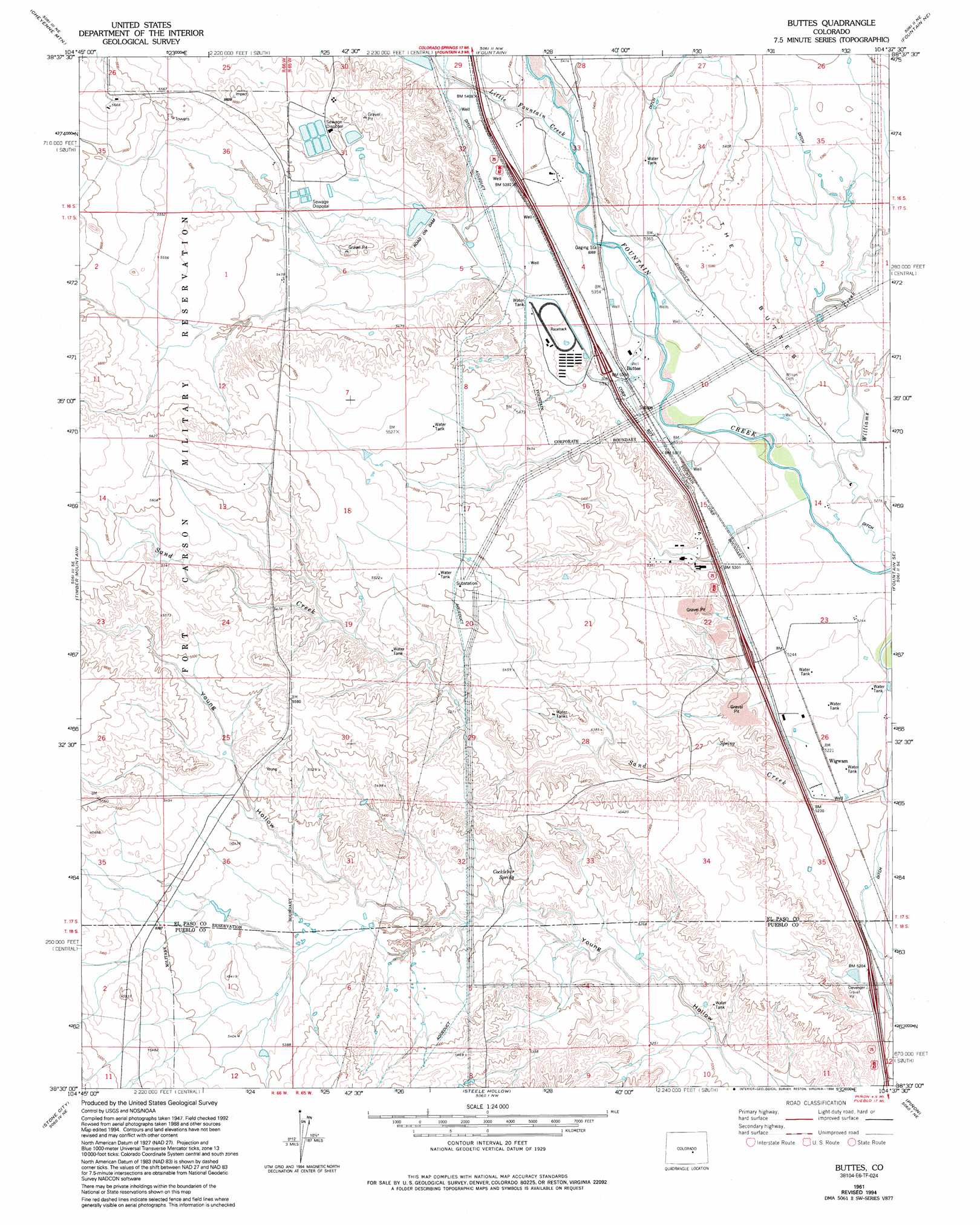
USGS Topo Quad 38104e6 - 1:24,000 scale
| Topo Map Name: | Buttes |
| USGS Topo Quad ID: | 38104e6 |
| Print Size: | ca. 21 1/4" wide x 27" high |
| Southeast Coordinates: | 38.5° N latitude / 104.625° W longitude |
| Map Center Coordinates: | 38.5625° N latitude / 104.6875° W longitude |
| U.S. State: | CO |
| Filename: | o38104e6.jpg |
| Download Map JPG Image: | Buttes topo map 1:24,000 scale |
| Map Type: | Topographic |
| Topo Series: | 7.5´ |
| Map Scale: | 1:24,000 |
| Source of Map Images: | United States Geological Survey (USGS) |
| Alternate Map Versions: |
Buttes CO 1949 Download PDF Buy paper map Buttes CO 1961, updated 1963 Download PDF Buy paper map Buttes CO 1961, updated 1968 Download PDF Buy paper map Buttes CO 1961, updated 1970 Download PDF Buy paper map Buttes CO 1961, updated 1970 Download PDF Buy paper map Buttes CO 1961, updated 1974 Download PDF Buy paper map Buttes CO 1961, updated 1978 Download PDF Buy paper map Buttes CO 1961, updated 1978 Download PDF Buy paper map Buttes CO 1961, updated 1994 Download PDF Buy paper map Buttes CO 2010 Download PDF Buy paper map Buttes CO 2013 Download PDF Buy paper map Buttes CO 2016 Download PDF Buy paper map |
1:24,000 Topo Quads surrounding Buttes
Manitou Springs |
Colorado Springs |
Elsmere |
Corral Bluffs |
Ellicott |
Mount Big Chief |
Cheyenne Mountain |
Fountain |
Fountain Ne |
Hanover Nw |
Mount Pittsburg |
Timber Mountain |
Buttes |
Fountain Se |
Hanover |
Pierce Gulch |
Stone City |
Steele Hollow |
Pinon |
Bar J H Ranch |
Hobson |
Swallows |
Northwest Pueblo |
Northeast Pueblo |
Devine |
> Back to 38104e1 at 1:100,000 scale
> Back to 38104a1 at 1:250,000 scale
> Back to U.S. Topo Maps home
Buttes topo map: Gazetteer
Buttes: Canals
Cotton Slough Ditch elevation 1614m 5295′Jackson and Burke Ditch elevation 1582m 5190′
Tom Wanlass Ditch elevation 1620m 5314′
Buttes: Dams
R D Nixon Dam elevation 1652m 5419′Buttes: Populated Places
Buttes elevation 1626m 5334′Henkel elevation 1579m 5180′
Wigwam elevation 1592m 5223′
Buttes: Reservoirs
R D Nixon Reservoir elevation 1652m 5419′Buttes: Springs
Cockllbur Spring elevation 1622m 5321′Buttes: Streams
Little Fountain Creek elevation 1639m 5377′Williams Creek elevation 1597m 5239′
Buttes: Summits
The Buttes elevation 1638m 5374′Buttes digital topo map on disk
Buy this Buttes topo map showing relief, roads, GPS coordinates and other geographical features, as a high-resolution digital map file on DVD: