Florence Se Topo Map Colorado
To zoom in, hover over the map of Florence Se
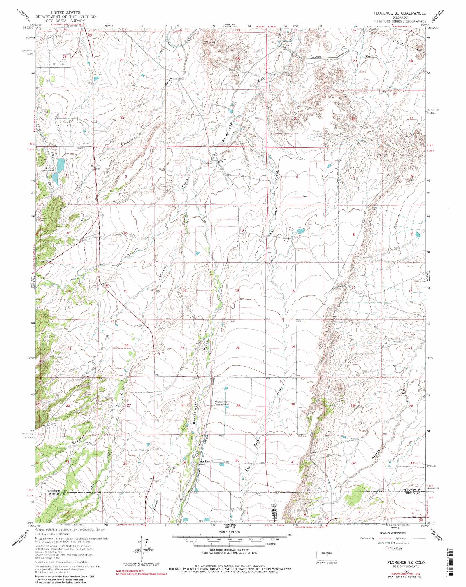
USGS Topo Quad 38105c1 - 1:24,000 scale
| Topo Map Name: | Florence Se |
| USGS Topo Quad ID: | 38105c1 |
| Print Size: | ca. 21 1/4" wide x 27" high |
| Southeast Coordinates: | 38.25° N latitude / 105° W longitude |
| Map Center Coordinates: | 38.3125° N latitude / 105.0625° W longitude |
| U.S. State: | CO |
| Filename: | o38105c1.jpg |
| Download Map JPG Image: | Florence Se topo map 1:24,000 scale |
| Map Type: | Topographic |
| Topo Series: | 7.5´ |
| Map Scale: | 1:24,000 |
| Source of Map Images: | United States Geological Survey (USGS) |
| Alternate Map Versions: |
Florence SE CO 1959, updated 1961 Download PDF Buy paper map Florence SE CO 1959, updated 1965 Download PDF Buy paper map Florence SE CO 1959, updated 1965 Download PDF Buy paper map Florence SE CO 1959, updated 1980 Download PDF Buy paper map Florence SE CO 1959, updated 1990 Download PDF Buy paper map Florence SE CO 1959, updated 1990 Download PDF Buy paper map Florence SE CO 2010 Download PDF Buy paper map Florence SE CO 2013 Download PDF Buy paper map Florence SE CO 2016 Download PDF Buy paper map |
1:24,000 Topo Quads surrounding Florence Se
Rice Mountain |
Cooper Mountain |
Phantom Canyon |
Mount Pittsburg |
Timber Mountain |
Royal Gorge |
Canon City |
Florence |
Pierce Gulch |
Stone City |
Curley Peak |
Rockvale |
Florence Se |
Hobson |
Swallows |
Mount Tyndall |
Hardscrabble Mountain |
Wetmore |
Owl Canyon |
Beulah Ne |
Rosita |
Deer Peak |
Saint Charles Peak |
Beulah |
Muldoon Hill |
> Back to 38105a1 at 1:100,000 scale
> Back to 38104a1 at 1:250,000 scale
> Back to U.S. Topo Maps home
Florence Se topo map: Gazetteer
Florence Se: Canals
Ciperts and Chapson Ditch elevation 1782m 5846′Florence Se: Populated Places
Sikes elevation 1809m 5935′Florence Se: Reservoirs
Florence City Water Reservoirs elevation 1690m 5544′Florence Se: Streams
Adobe Creek elevation 1757m 5764′Fourmile Creek elevation 1763m 5784′
Low Black Creek elevation 1602m 5255′
Mineral Creek elevation 1653m 5423′
Newlin Creek elevation 1618m 5308′
Florence Se: Valleys
Tennant Gulch elevation 1702m 5583′Florence Se digital topo map on disk
Buy this Florence Se topo map showing relief, roads, GPS coordinates and other geographical features, as a high-resolution digital map file on DVD: