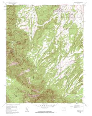
Rockvale Topo Map Colorado
To zoom in, hover over the map of Rockvale
USGS Topo Quad 38105c2 - 1:24,000 scale
| Topo Map Name: | Rockvale |
| USGS Topo Quad ID: | 38105c2 |
| Print Size: | ca. 21 1/4" wide x 27" high |
| Southeast Coordinates: | 38.25° N latitude / 105.125° W longitude |
| Map Center Coordinates: | 38.3125° N latitude / 105.1875° W longitude |
| U.S. State: | CO |
| Filename: | o38105c2.jpg |
| Download Map JPG Image: | Rockvale topo map 1:24,000 scale |
| Map Type: | Topographic |
| Topo Series: | 7.5´ |
| Map Scale: | 1:24,000 |
| Source of Map Images: | United States Geological Survey (USGS) |
| Alternate Map Versions: |
Rockvale CO 1959, updated 1961 Download PDF Buy paper map Rockvale CO 1959, updated 1961 Download PDF Buy paper map Rockvale CO 1959, updated 1964 Download PDF Buy paper map Rockvale CO 1994, updated 1998 Download PDF Buy paper map Rockvale CO 2011 Download PDF Buy paper map Rockvale CO 2013 Download PDF Buy paper map Rockvale CO 2016 Download PDF Buy paper map |
| FStopo: | US Forest Service topo Rockvale is available: Download FStopo PDF Download FStopo TIF |
1:24,000 Topo Quads surrounding Rockvale
> Back to 38105a1 at 1:100,000 scale
> Back to 38104a1 at 1:250,000 scale
> Back to U.S. Topo Maps home
Rockvale topo map: Gazetteer
Rockvale: Cliffs
Stony Point elevation 2089m 6853′Rockvale: Flats
Locke Park elevation 2768m 9081′Rockvale: Mines
Bassick Mine elevation 1781m 5843′Beacon Mine elevation 1766m 5793′
Bentley Pegmatite Mine elevation 1987m 6519′
Black Diamond Mine elevation 1899m 6230′
Black Diamond Mine elevation 1889m 6197′
Black Hawk Quarry elevation 1869m 6131′
Black Knight Claypit elevation 1788m 5866′
Black Knight Mine elevation 1785m 5856′
Caldirola Number 1 Mine elevation 1779m 5836′
Caldirola Number 2 Mine elevation 1808m 5931′
Caldirola Pit elevation 1927m 6322′
Canon Chief Mine elevation 1892m 6207′
Canon Imperial Mine elevation 1604m 5262′
Canon Liberty Mine elevation 1880m 6167′
Canon Monarch Mine elevation 1996m 6548′
Canon National Mine elevation 1932m 6338′
Canon Peacock Mine elevation 1907m 6256′
Canon Shamrock Mine elevation 1971m 6466′
Canon Zenith Mine elevation 1856m 6089′
Carson Mine elevation 1805m 5921′
Cedar Canon Mine elevation 1751m 5744′
Coal Creek Canyon Mine elevation 1803m 5915′
Coal Creek Number 2 Mine elevation 1669m 5475′
Corley Number 6 Mine elevation 1891m 6204′
Dilley Ranch Mine elevation 2801m 9189′
Dorchester Number One Mine elevation 1934m 6345′
Double Dick Mines elevation 1911m 6269′
Golden Quality Number Five Mine elevation 1853m 6079′
Grape Creek Mine elevation 2047m 6715′
Grey Creek Mine elevation 2005m 6578′
Kenwood Mine elevation 1745m 5725′
Last Hope Claims elevation 2089m 6853′
Manley Mine elevation 1971m 6466′
Miller Mine elevation 1826m 5990′
Monarch Number 4 Mine elevation 1996m 6548′
Oak Creek Grade Prospect elevation 2109m 6919′
Pine Gulch Mines elevation 1900m 6233′
Radiant Mine elevation 1755m 5757′
Rawley Mines elevation 1721m 5646′
Red Carbon Mine elevation 1945m 6381′
Rex Carbon Mine elevation 1946m 6384′
Rockafellow Mine elevation 1873m 6145′
Rockvale Mine elevation 1668m 5472′
Serpent Prospect elevation 2047m 6715′
Shaw Opening Mine elevation 1774m 5820′
Smith Mine elevation 1926m 6318′
South Field Area elevation 1923m 6309′
Southfield Cherokee Mine elevation 1857m 6092′
Twin Pines Mine elevation 1769m 5803′
Venta Mine elevation 1898m 6227′
Rockvale: Populated Places
Chandler (historical) elevation 1749m 5738′Coal Creek elevation 1654m 5426′
Rockvale elevation 1665m 5462′
Rockvale: Streams
First Alkali Creek elevation 1601m 5252′Mill Creek elevation 1790m 5872′
North Cow Creek elevation 1725m 5659′
Second Alkali Creek elevation 1617m 5305′
Second Newlin Creek elevation 2676m 8779′
South Chandler Creek elevation 1858m 6095′
South Newlin Creek elevation 2302m 7552′
South Oak Creek elevation 1646m 5400′
Third Newlin Creek elevation 2519m 8264′
Rockvale: Summits
Round Mountain elevation 2408m 7900′Rockvale: Trails
Sheeley Trail elevation 2353m 7719′Rockvale: Valleys
Coal Creek Canyon elevation 1776m 5826′Middle Fork Coal Creek Canyon elevation 2126m 6975′
Stultz Gulch elevation 2043m 6702′
West Fork Coal Creek Canyon elevation 2065m 6774′
Rockvale digital topo map on disk
Buy this Rockvale topo map showing relief, roads, GPS coordinates and other geographical features, as a high-resolution digital map file on DVD:


