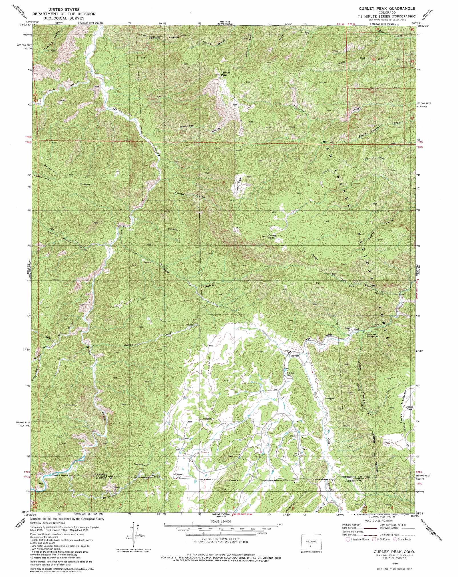
Curley Peak Topo Map Colorado
To zoom in, hover over the map of Curley Peak
USGS Topo Quad 38105c3 - 1:24,000 scale
| Topo Map Name: | Curley Peak |
| USGS Topo Quad ID: | 38105c3 |
| Print Size: | ca. 21 1/4" wide x 27" high |
| Southeast Coordinates: | 38.25° N latitude / 105.25° W longitude |
| Map Center Coordinates: | 38.3125° N latitude / 105.3125° W longitude |
| U.S. State: | CO |
| Filename: | o38105c3.jpg |
| Download Map JPG Image: | Curley Peak topo map 1:24,000 scale |
| Map Type: | Topographic |
| Topo Series: | 7.5´ |
| Map Scale: | 1:24,000 |
| Source of Map Images: | United States Geological Survey (USGS) |
| Alternate Map Versions: |
Curley Peak CO 1980, updated 1981 Download PDF Buy paper map Curley Peak CO 1980, updated 1981 Download PDF Buy paper map Curley Peak CO 1980, updated 1983 Download PDF Buy paper map Curley Peak CO 1994, updated 1998 Download PDF Buy paper map Curley Peak CO 2011 Download PDF Buy paper map Curley Peak CO 2013 Download PDF Buy paper map Curley Peak CO 2016 Download PDF Buy paper map |
| FStopo: | US Forest Service topo Curley Peak is available: Download FStopo PDF Download FStopo TIF |
1:24,000 Topo Quads surrounding Curley Peak
Hall Gulch |
Gribble Mountain |
Rice Mountain |
Cooper Mountain |
Phantom Canyon |
Echo |
Mcintyre Hills |
Royal Gorge |
Canon City |
Florence |
Hillside |
Iron Mountain |
Curley Peak |
Rockvale |
Florence Se |
Beckwith Mountain |
Westcliffe |
Mount Tyndall |
Hardscrabble Mountain |
Wetmore |
Horn Peak |
Aldrich Gulch |
Rosita |
Deer Peak |
Saint Charles Peak |
> Back to 38105a1 at 1:100,000 scale
> Back to 38104a1 at 1:250,000 scale
> Back to U.S. Topo Maps home
Curley Peak topo map: Gazetteer
Curley Peak: Bridges
Royal Gorge Bridge elevation 2394m 7854′Curley Peak: Flats
Chute Park elevation 2733m 8966′Curley Peak: Mines
A Griffin Ranch Mine elevation 2394m 7854′Big Chief One Mine elevation 2613m 8572′
Big Mac Group One-three Mines elevation 2437m 7995′
Deer Ridge Claim elevation 2445m 8021′
Curley Peak: Populated Places
Galena elevation 2422m 7946′Yorkville elevation 2382m 7814′
Curley Peak: Ridges
Scrapping Ridges elevation 2274m 7460′Curley Peak: Streams
Democrat Creek elevation 2202m 7224′Curley Peak: Summits
Curley Peak elevation 2914m 9560′Locke Mountain elevation 2808m 9212′
McKinley Mountain elevation 2564m 8412′
Tanner Peak elevation 2845m 9333′
Curley Peak: Trails
Highline Trail elevation 2572m 8438′Stultz Trail elevation 2696m 8845′
Tanner Trail elevation 2386m 7828′
Curley Peak: Valleys
Bear Gulch elevation 2075m 6807′Chute Gulch elevation 2043m 6702′
East Bear Gulch elevation 2245m 7365′
East Mill Gulch elevation 2119m 6952′
Granite Gulch elevation 2196m 7204′
Hale Gulch elevation 1920m 6299′
Isinglass Gulch elevation 2016m 6614′
Lion Canyon elevation 2324m 7624′
Little Granite Gulch elevation 2229m 7312′
Pine Gulch elevation 1950m 6397′
Ralph Gulch elevation 2431m 7975′
Curley Peak digital topo map on disk
Buy this Curley Peak topo map showing relief, roads, GPS coordinates and other geographical features, as a high-resolution digital map file on DVD: