Cotopaxi Topo Map Colorado
To zoom in, hover over the map of Cotopaxi
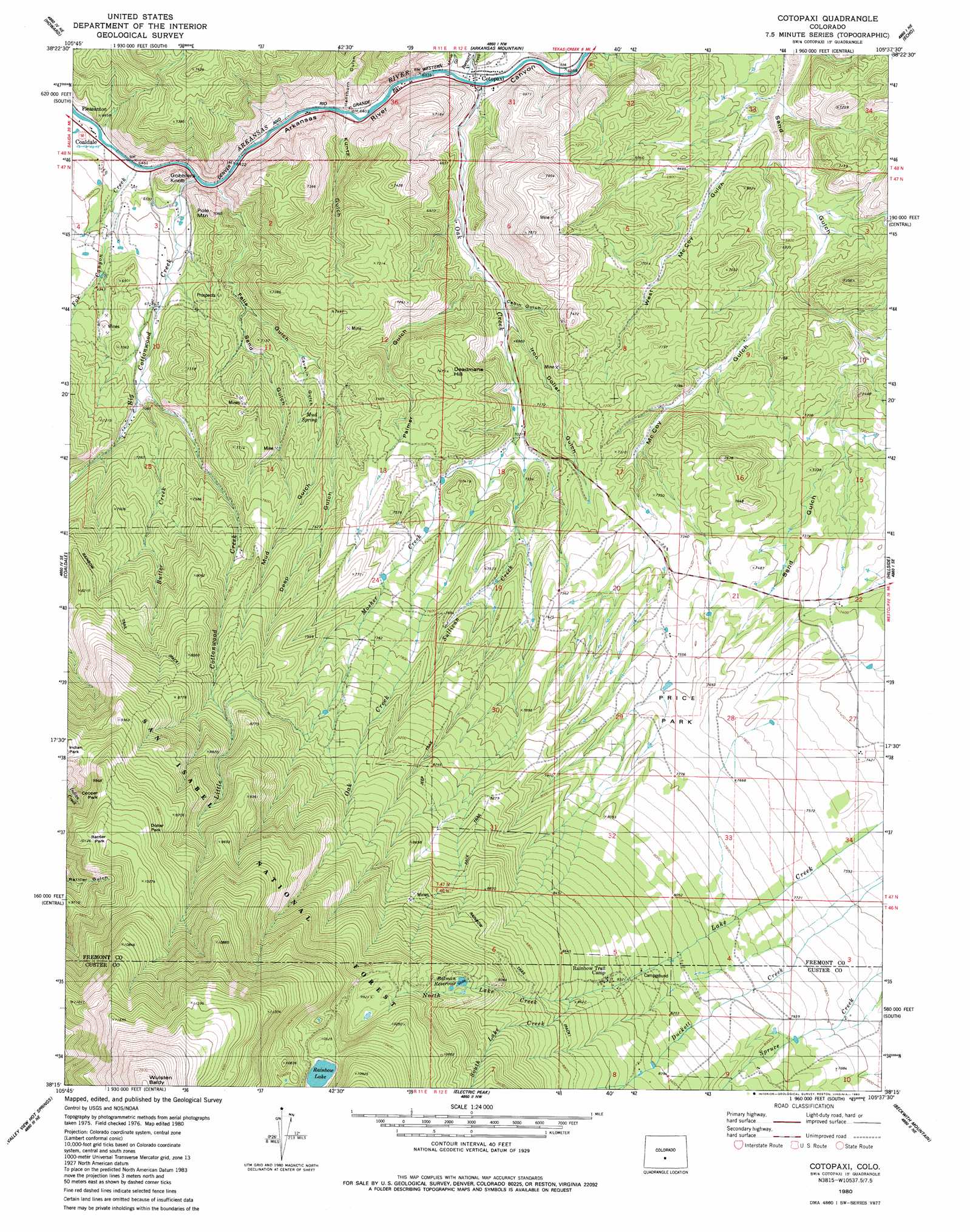
USGS Topo Quad 38105c6 - 1:24,000 scale
| Topo Map Name: | Cotopaxi |
| USGS Topo Quad ID: | 38105c6 |
| Print Size: | ca. 21 1/4" wide x 27" high |
| Southeast Coordinates: | 38.25° N latitude / 105.625° W longitude |
| Map Center Coordinates: | 38.3125° N latitude / 105.6875° W longitude |
| U.S. State: | CO |
| Filename: | o38105c6.jpg |
| Download Map JPG Image: | Cotopaxi topo map 1:24,000 scale |
| Map Type: | Topographic |
| Topo Series: | 7.5´ |
| Map Scale: | 1:24,000 |
| Source of Map Images: | United States Geological Survey (USGS) |
| Alternate Map Versions: |
Cotopaxi CO 1980, updated 1980 Download PDF Buy paper map Cotopaxi CO 1994, updated 1998 Download PDF Buy paper map Cotopaxi CO 2011 Download PDF Buy paper map Cotopaxi CO 2013 Download PDF Buy paper map Cotopaxi CO 2016 Download PDF Buy paper map |
| FStopo: | US Forest Service topo Cotopaxi is available: Download FStopo PDF Download FStopo TIF |
1:24,000 Topo Quads surrounding Cotopaxi
Salida East |
Jack Hall Mountain |
Waugh Mountain |
Hall Gulch |
Gribble Mountain |
Wellsville |
Howard |
Arkansas Mountain |
Echo |
Mcintyre Hills |
Bushnell Peak |
Coaldale |
Cotopaxi |
Hillside |
Iron Mountain |
Villa Grove |
Valley View Hot Springs |
Electric Peak |
Beckwith Mountain |
Westcliffe |
Moffat North |
Mirage |
Rito Alto Peak |
Horn Peak |
Aldrich Gulch |
> Back to 38105a1 at 1:100,000 scale
> Back to 38104a1 at 1:250,000 scale
> Back to U.S. Topo Maps home
Cotopaxi topo map: Gazetteer
Cotopaxi: Dams
Balman Dam elevation 2997m 9832′Cotopaxi: Flats
Price Park elevation 2326m 7631′Cotopaxi: Lakes
Rainbow Lake elevation 3158m 10360′Cotopaxi: Mines
Blue Spar Mine elevation 2186m 7171′Jones and Young Lease Mine elevation 2054m 6738′
Lightning Group Mine elevation 2285m 7496′
Lightning Number Two Mine elevation 2165m 7103′
Perry de Lellis Claim elevation 2309m 7575′
Cotopaxi: Parks
Dollar Park elevation 3072m 10078′Indian Park elevation 2909m 9543′
Rattler Park elevation 3089m 10134′
Cotopaxi: Populated Places
Cotopaxi elevation 1939m 6361′Pleasanton elevation 1977m 6486′
Cotopaxi: Reservoirs
Balman Reservoir elevation 2874m 9429′Cotopaxi: Springs
Mud Spring elevation 2184m 7165′Cotopaxi: Streams
Bernard Creek elevation 1938m 6358′Big Cottonwood Creek elevation 1965m 6446′
Butter Creek elevation 2128m 6981′
Fox Canyon Creek elevation 1964m 6443′
Little Cottonwood Creek elevation 2090m 6856′
Mosher Creek elevation 2153m 7063′
North Lake Creek elevation 2594m 8510′
Oak Creek elevation 1938m 6358′
South Lake Creek elevation 2594m 8510′
Sullivan Creek elevation 2133m 6998′
Cotopaxi: Summits
Deadmans Hill elevation 2272m 7454′Gobblers Knob elevation 2076m 6811′
Pole Mountain elevation 2130m 6988′
Wulsten Baldy elevation 3870m 12696′
Cotopaxi: Trails
Rainbow Trail elevation 2559m 8395′Cotopaxi: Valleys
Cabin Gulch elevation 2073m 6801′Cave-in Gulch elevation 2114m 6935′
Deep Gulch elevation 2163m 7096′
Falls Gulch elevation 1981m 6499′
Henthorn Gulch elevation 1954m 6410′
Iron Dollar Gulch elevation 2073m 6801′
Kuntz Gulch elevation 1952m 6404′
McCoy Gulch elevation 1997m 6551′
Mine Gulch elevation 2010m 6594′
Palmer Gulch elevation 2047m 6715′
West Mc Coy Gulch elevation 1989m 6525′
Cotopaxi digital topo map on disk
Buy this Cotopaxi topo map showing relief, roads, GPS coordinates and other geographical features, as a high-resolution digital map file on DVD: