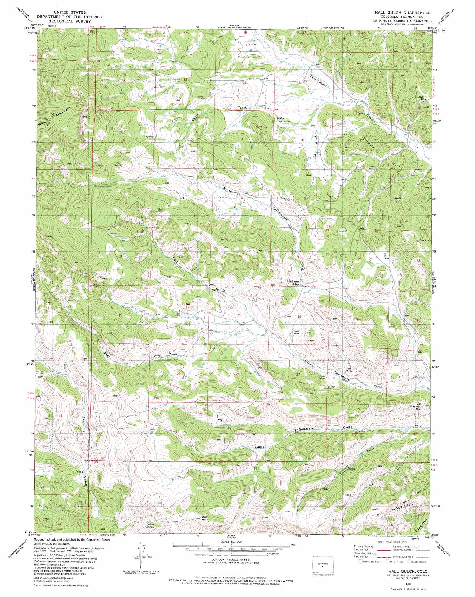
Hall Gulch Topo Map Colorado
To zoom in, hover over the map of Hall Gulch
USGS Topo Quad 38105e5 - 1:24,000 scale
| Topo Map Name: | Hall Gulch |
| USGS Topo Quad ID: | 38105e5 |
| Print Size: | ca. 21 1/4" wide x 27" high |
| Southeast Coordinates: | 38.5° N latitude / 105.5° W longitude |
| Map Center Coordinates: | 38.5625° N latitude / 105.5625° W longitude |
| U.S. State: | CO |
| Filename: | o38105e5.jpg |
| Download Map JPG Image: | Hall Gulch topo map 1:24,000 scale |
| Map Type: | Topographic |
| Topo Series: | 7.5´ |
| Map Scale: | 1:24,000 |
| Source of Map Images: | United States Geological Survey (USGS) |
| Alternate Map Versions: |
Hall Gulch CO 1983, updated 1983 Download PDF Buy paper map Hall Gulch CO 2010 Download PDF Buy paper map Hall Gulch CO 2013 Download PDF Buy paper map Hall Gulch CO 2016 Download PDF Buy paper map |
1:24,000 Topo Quads surrounding Hall Gulch
Agate Mountain |
Dicks Peak |
Thirtynine Mile Mountain |
Witcher Mountain |
Wrights Reservoir |
Gribbles Park |
Black Mountain |
Thirtyone Mile Mountain |
Cover Mountain |
High Park |
Jack Hall Mountain |
Waugh Mountain |
Hall Gulch |
Gribble Mountain |
Rice Mountain |
Howard |
Arkansas Mountain |
Echo |
Mcintyre Hills |
Royal Gorge |
Coaldale |
Cotopaxi |
Hillside |
Iron Mountain |
Curley Peak |
> Back to 38105e1 at 1:100,000 scale
> Back to 38104a1 at 1:250,000 scale
> Back to U.S. Topo Maps home
Hall Gulch topo map: Gazetteer
Hall Gulch: Dams
Hook Dam elevation 2769m 9084′Hall Gulch: Mines
Dickson-Snooper Mine elevation 2659m 8723′Glen Williams Mine elevation 2477m 8126′
Glen Williams Mine elevation 2449m 8034′
Joan Two Mine elevation 2577m 8454′
Little Abner Number One Mine elevation 2561m 8402′
Mary L Group Mine elevation 2561m 8402′
Thorne Mine elevation 2521m 8270′
Hall Gulch: Reservoirs
Hook Reservoir elevation 2769m 9084′Hall Gulch: Springs
Taylor Soda Spring elevation 2481m 8139′Hall Gulch: Streams
Fear Creek elevation 2497m 8192′Kelly Creek elevation 2402m 7880′
Middle Tallahassee Creek elevation 2382m 7814′
North Tallahassee Creek elevation 2382m 7814′
Salt Creek elevation 2450m 8038′
Squaw Creek elevation 2450m 8038′
Hall Gulch: Summits
Soapy Hill elevation 2701m 8861′Table Mountain elevation 2810m 9219′
Hall Gulch: Valleys
Hall Gulch elevation 2501m 8205′Hall Gulch digital topo map on disk
Buy this Hall Gulch topo map showing relief, roads, GPS coordinates and other geographical features, as a high-resolution digital map file on DVD: