Spinney Mountain Topo Map Colorado
To zoom in, hover over the map of Spinney Mountain
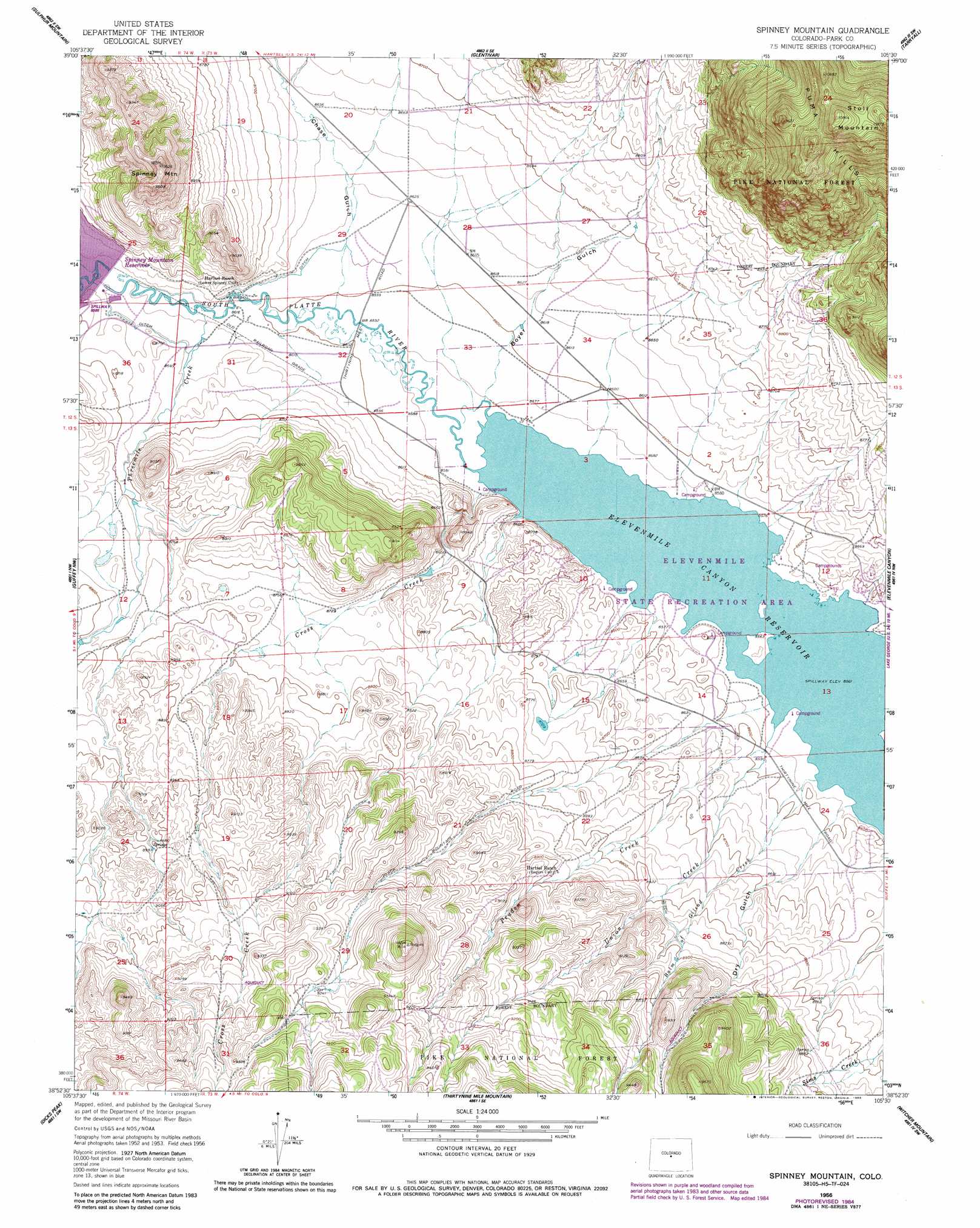
USGS Topo Quad 38105h5 - 1:24,000 scale
| Topo Map Name: | Spinney Mountain |
| USGS Topo Quad ID: | 38105h5 |
| Print Size: | ca. 21 1/4" wide x 27" high |
| Southeast Coordinates: | 38.875° N latitude / 105.5° W longitude |
| Map Center Coordinates: | 38.9375° N latitude / 105.5625° W longitude |
| U.S. State: | CO |
| Filename: | o38105h5.jpg |
| Download Map JPG Image: | Spinney Mountain topo map 1:24,000 scale |
| Map Type: | Topographic |
| Topo Series: | 7.5´ |
| Map Scale: | 1:24,000 |
| Source of Map Images: | United States Geological Survey (USGS) |
| Alternate Map Versions: |
Spinney Mountain CO 1956, updated 1958 Download PDF Buy paper map Spinney Mountain CO 1956, updated 1985 Download PDF Buy paper map Spinney Mountain CO 1994, updated 1998 Download PDF Buy paper map Spinney Mountain CO 2011 Download PDF Buy paper map Spinney Mountain CO 2013 Download PDF Buy paper map Spinney Mountain CO 2016 Download PDF Buy paper map |
| FStopo: | US Forest Service topo Spinney Mountain is available: Download FStopo PDF Download FStopo TIF |
1:24,000 Topo Quads surrounding Spinney Mountain
Elkhorn |
Eagle Rock |
Farnum Peak |
Mccurdy Mountain |
Cheesman Lake |
Hartsel |
Sulphur Mountain |
Glentivar |
Tarryall |
Hackett Mountain |
Antero Reservoir Ne |
Guffey Nw |
Spinney Mountain |
Elevenmile Canyon |
Lake George |
Agate Mountain |
Dicks Peak |
Thirtynine Mile Mountain |
Witcher Mountain |
Wrights Reservoir |
Gribbles Park |
Black Mountain |
Thirtyone Mile Mountain |
Cover Mountain |
High Park |
> Back to 38105e1 at 1:100,000 scale
> Back to 38104a1 at 1:250,000 scale
> Back to U.S. Topo Maps home
Spinney Mountain topo map: Gazetteer
Spinney Mountain: Mines
Spinney Mountain Mine elevation 2748m 9015′Spinney Mountain: Parks
Elevenmile State Recreation Area elevation 2611m 8566′Spinney Mountain: Reservoirs
Spinney Mountain Reservoir elevation 2649m 8690′Spinney Mountain: Streams
Balm of Gilead Creek elevation 2611m 8566′Cross Creek elevation 2611m 8566′
Pruden Creek elevation 2618m 8589′
Threemile Creek elevation 2626m 8615′
Union Creek elevation 2611m 8566′
Spinney Mountain: Summits
Spinney Mountain elevation 2892m 9488′Stoll Mountain elevation 3299m 10823′
Spinney Mountain: Valleys
Boyer Gulch elevation 2617m 8585′Chase Gulch elevation 2621m 8599′
Dry Gulch elevation 2615m 8579′
Spinney Mountain digital topo map on disk
Buy this Spinney Mountain topo map showing relief, roads, GPS coordinates and other geographical features, as a high-resolution digital map file on DVD: