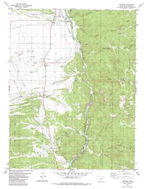
Nathrop Topo Map Colorado
To zoom in, hover over the map of Nathrop
USGS Topo Quad 38106f1 - 1:24,000 scale
| Topo Map Name: | Nathrop |
| USGS Topo Quad ID: | 38106f1 |
| Print Size: | ca. 21 1/4" wide x 27" high |
| Southeast Coordinates: | 38.625° N latitude / 106° W longitude |
| Map Center Coordinates: | 38.6875° N latitude / 106.0625° W longitude |
| U.S. State: | CO |
| Filename: | o38106f1.jpg |
| Download Map JPG Image: | Nathrop topo map 1:24,000 scale |
| Map Type: | Topographic |
| Topo Series: | 7.5´ |
| Map Scale: | 1:24,000 |
| Source of Map Images: | United States Geological Survey (USGS) |
| Alternate Map Versions: |
Nathrop CO 1983, updated 1983 Download PDF Buy paper map Nathrop CO 1994, updated 1998 Download PDF Buy paper map Nathrop CO 2011 Download PDF Buy paper map Nathrop CO 2013 Download PDF Buy paper map Nathrop CO 2016 Download PDF Buy paper map |
| FStopo: | US Forest Service topo Nathrop is available: Download FStopo PDF Download FStopo TIF |
1:24,000 Topo Quads surrounding Nathrop
> Back to 38106e1 at 1:100,000 scale
> Back to 38106a1 at 1:250,000 scale
> Back to U.S. Topo Maps home
Nathrop topo map: Gazetteer
Nathrop: Mines
American Flag Mine elevation 2710m 8891′American Fluorspar Mine Company Mine elevation 2357m 7732′
Anaconda Mine elevation 2710m 8891′
Bancroft Incline Mine elevation 2325m 7627′
Bancroft Mine elevation 2308m 7572′
Blue Stone Mine elevation 2355m 7726′
Calumet Iron Mine elevation 2710m 8891′
Chaffee County Fluorspar Mine elevation 2317m 7601′
Colorado Fluorspar Company Mine elevation 2266m 7434′
Crete Mine elevation 2710m 8891′
Curly Lee Shaft Mine elevation 2307m 7568′
Dangerfield Mine elevation 2710m 8891′
Golden Island Mine elevation 2710m 8891′
Herksberger Tunnel Mine elevation 2710m 8891′
Hill Top Mine elevation 2310m 7578′
Holdredge Mine elevation 2710m 8891′
Joe Robesnick Mine elevation 2266m 7434′
Kramer Mine elevation 2352m 7716′
Lionelle Mine elevation 2371m 7778′
Mascot Mine elevation 2710m 8891′
Mill Tunnel Mine elevation 2266m 7434′
Morgan Ranch Mine elevation 2317m 7601′
Nutmeg Mine elevation 2710m 8891′
Snowflake Lode Mine elevation 2307m 7568′
Snowflake Number Two Mine elevation 2307m 7568′
Sunset Mine elevation 2710m 8891′
Tiger Lily Mine elevation 2355m 7726′
Trefone Tunnel Mine elevation 2266m 7434′
Vivandiere Mine elevation 2710m 8891′
White King Group Mine elevation 2368m 7769′
Nathrop: Populated Places
Centerville elevation 2388m 7834′Nathrop (historical) elevation 2341m 7680′
Swan (historical) elevation 2281m 7483′
Nathrop: Springs
Browns Canyon Warm Spring elevation 2284m 7493′Browns Grotto Warm Spring elevation 2264m 7427′
Nathrop: Streams
Bassam Creek elevation 2378m 7801′Browns Creek elevation 2291m 7516′
Chalk Creek elevation 2317m 7601′
Cottonwood Creek elevation 2305m 7562′
Eddy Creek elevation 2335m 7660′
Fourmile Creek elevation 2268m 7440′
Gas Creek elevation 2307m 7568′
Little Cottonwood Creek elevation 2317m 7601′
Pioneer Ditch elevation 2326m 7631′
Threemile Creek elevation 2232m 7322′
Nathrop: Summits
Ruby Mountain elevation 2432m 7979′The Reef elevation 2556m 8385′
Nathrop: Valleys
Cat Gulch elevation 2368m 7769′Green Gulch elevation 2324m 7624′
Railroad Gulch elevation 2259m 7411′
Sawmill Gulch elevation 2425m 7956′
Spring Gulch elevation 2290m 7513′
Stafford Gulch elevation 2343m 7687′
Nathrop digital topo map on disk
Buy this Nathrop topo map showing relief, roads, GPS coordinates and other geographical features, as a high-resolution digital map file on DVD:


