Almont Topo Map Colorado
To zoom in, hover over the map of Almont
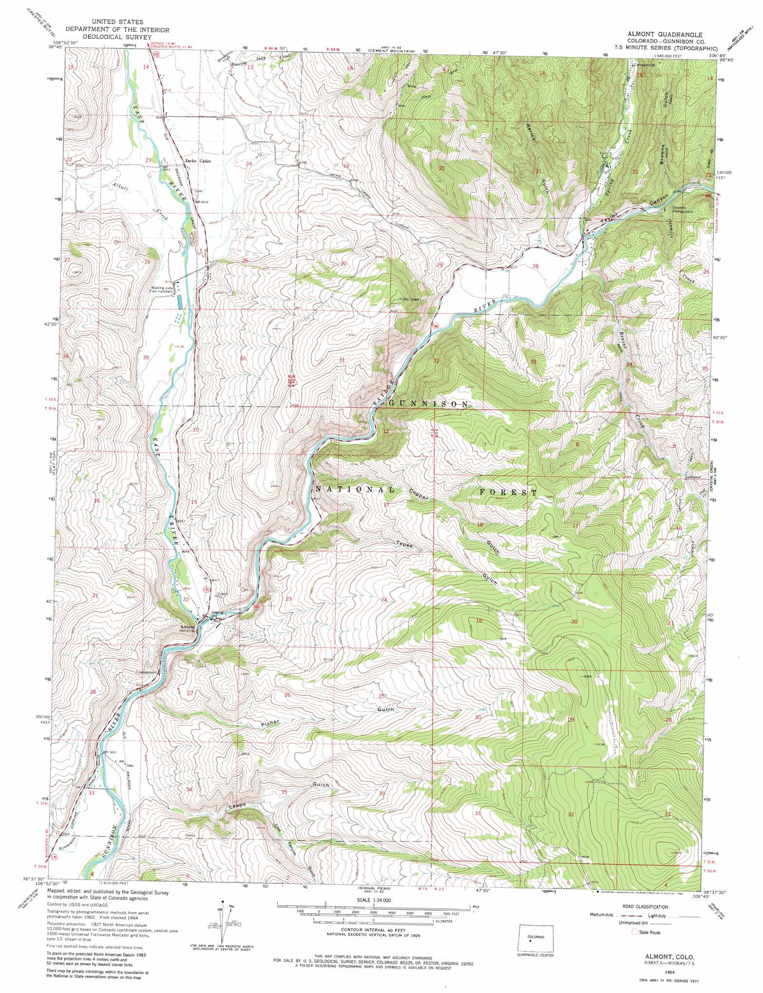
USGS Topo Quad 38106f7 - 1:24,000 scale
| Topo Map Name: | Almont |
| USGS Topo Quad ID: | 38106f7 |
| Print Size: | ca. 21 1/4" wide x 27" high |
| Southeast Coordinates: | 38.625° N latitude / 106.75° W longitude |
| Map Center Coordinates: | 38.6875° N latitude / 106.8125° W longitude |
| U.S. State: | CO |
| Filename: | o38106f7.jpg |
| Download Map JPG Image: | Almont topo map 1:24,000 scale |
| Map Type: | Topographic |
| Topo Series: | 7.5´ |
| Map Scale: | 1:24,000 |
| Source of Map Images: | United States Geological Survey (USGS) |
| Alternate Map Versions: |
Almont CO 1964, updated 1967 Download PDF Buy paper map Almont CO 1964, updated 1967 Download PDF Buy paper map Almont CO 1964, updated 1980 Download PDF Buy paper map Almont CO 1964, updated 1980 Download PDF Buy paper map Almont CO 1964, updated 1980 Download PDF Buy paper map Almont CO 2001, updated 2004 Download PDF Buy paper map Almont CO 2011 Download PDF Buy paper map Almont CO 2013 Download PDF Buy paper map Almont CO 2016 Download PDF Buy paper map |
| FStopo: | US Forest Service topo Almont is available: Download FStopo PDF Download FStopo TIF |
1:24,000 Topo Quads surrounding Almont
Oh-Be-Joyful |
Gothic |
Pearl Pass |
Italian Creek |
Pieplant |
Mount Axtell |
Crested Butte |
Cement Mountain |
Matchless Mountain |
Taylor Park Reservoir |
Squirrel Creek |
Flat Top |
Almont |
Crystal Creek |
Fairview Peak |
Mcintosh Mountain |
Gunnison |
Signal Peak |
Parlin |
Pitkin |
Big Mesa |
Iris Nw |
Iris |
Houston Gulch |
Doyleville |
> Back to 38106e1 at 1:100,000 scale
> Back to 38106a1 at 1:250,000 scale
> Back to U.S. Topo Maps home
Almont topo map: Gazetteer
Almont: Parks
Gunnison City Mountain Park elevation 2525m 8284′Roaring Judy Fish Hatchery elevation 2502m 8208′
Roaring Judy State Wildlife Area elevation 2486m 8156′
Almont: Populated Places
Almont elevation 2445m 8021′Almont: Streams
Alkali Creek elevation 2497m 8192′Beaver Creek elevation 2531m 8303′
Cliff Creek elevation 2644m 8674′
East River elevation 2440m 8005′
Onemile Creek elevation 2549m 8362′
Roaring Judy Creek elevation 2558m 8392′
Slumgullion Creek elevation 2557m 8389′
Spring Creek elevation 2538m 8326′
Taylor River elevation 2440m 8005′
Almont: Trails
Onemile Cattle Trail elevation 2717m 8914′Almont: Valleys
Browns Gulch elevation 2577m 8454′Copper Gulch elevation 2476m 8123′
Fisher Gulch elevation 2435m 7988′
Leaps Gulch elevation 2435m 7988′
Lost Canyon Gulch elevation 2496m 8188′
Rarick Gulch elevation 2547m 8356′
Taylor Canyon elevation 2536m 8320′
Tepee Gulch elevation 2482m 8143′
Trail Gulch elevation 2574m 8444′
Almont digital topo map on disk
Buy this Almont topo map showing relief, roads, GPS coordinates and other geographical features, as a high-resolution digital map file on DVD: