Buena Vista West Topo Map Colorado
To zoom in, hover over the map of Buena Vista West
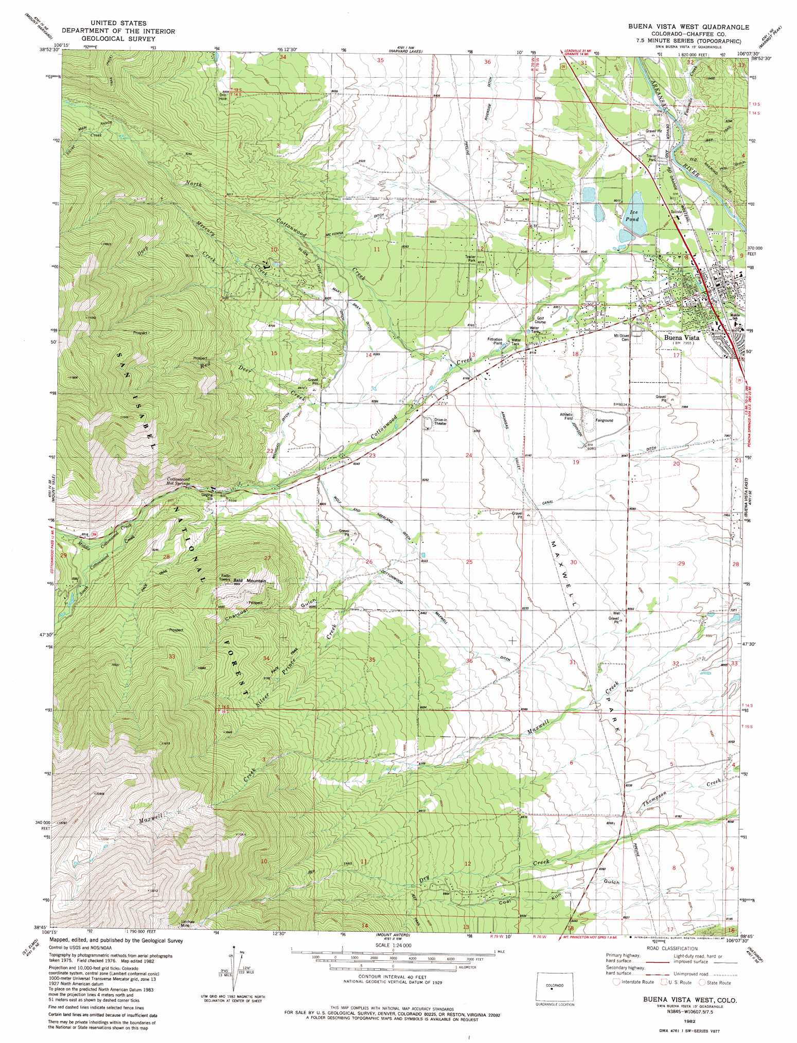
USGS Topo Quad 38106g2 - 1:24,000 scale
| Topo Map Name: | Buena Vista West |
| USGS Topo Quad ID: | 38106g2 |
| Print Size: | ca. 21 1/4" wide x 27" high |
| Southeast Coordinates: | 38.75° N latitude / 106.125° W longitude |
| Map Center Coordinates: | 38.8125° N latitude / 106.1875° W longitude |
| U.S. State: | CO |
| Filename: | o38106g2.jpg |
| Download Map JPG Image: | Buena Vista West topo map 1:24,000 scale |
| Map Type: | Topographic |
| Topo Series: | 7.5´ |
| Map Scale: | 1:24,000 |
| Source of Map Images: | United States Geological Survey (USGS) |
| Alternate Map Versions: |
Buena Vista West CO 1982, updated 1983 Download PDF Buy paper map Buena Vista West CO 1982, updated 1983 Download PDF Buy paper map Buena Vista West CO 1982, updated 1987 Download PDF Buy paper map Buena Vista West CO 2011 Download PDF Buy paper map Buena Vista West CO 2013 Download PDF Buy paper map Buena Vista West CO 2016 Download PDF Buy paper map |
| FStopo: | US Forest Service topo Buena Vista West is available: Download FStopo PDF Download FStopo TIF |
1:24,000 Topo Quads surrounding Buena Vista West
Mount Elbert |
Granite |
South Peak |
Jones Hill |
Garo |
Winfield |
Mount Harvard |
Harvard Lakes |
Marmot Peak |
Antero Reservoir |
Tincup |
Mount Yale |
Buena Vista West |
Buena Vista East |
Castle Rock Gulch |
Cumberland Pass |
Saint Elmo |
Mount Antero |
Nathrop |
Cameron Mountain |
Whitepine |
Garfield |
Maysville |
Salida West |
Salida East |
> Back to 38106e1 at 1:100,000 scale
> Back to 38106a1 at 1:250,000 scale
> Back to U.S. Topo Maps home
Buena Vista West topo map: Gazetteer
Buena Vista West: Canals
Arkansas Valley Canal elevation 2488m 8162′Cottonwood Maxwell Ditch elevation 2570m 8431′
Johnson Ditch elevation 2439m 8001′
Mary Bray Ditch elevation 2558m 8392′
McKenna Ditch elevation 2569m 8428′
Michigan Ditch elevation 2579m 8461′
Silver Creek Ditch elevation 2555m 8382′
Wolf and Neerland Ditch elevation 2537m 8323′
Buena Vista West: Mines
Annie C Mine elevation 2426m 7959′Be True Mine elevation 2426m 7959′
Big Chief Tunnel Mine elevation 2426m 7959′
Blakes Wonder Placer Mine elevation 2426m 7959′
Doris Ruby Group Mine elevation 2426m 7959′
Eureka Mountain Mine elevation 2426m 7959′
Josephine Quarry elevation 2426m 7959′
Lachaw Mine elevation 3429m 11250′
Latchaw Mine elevation 3613m 11853′
Little Annie Mine elevation 2426m 7959′
Mary A Claims Mine elevation 2426m 7959′
Mizpah Mine elevation 2426m 7959′
Quaker Mine elevation 2426m 7959′
Speedy Mine elevation 2426m 7959′
Sunset Shaft Mine elevation 2426m 7959′
Tom Collins Mine elevation 2442m 8011′
Yellow Bird Mine elevation 2426m 7959′
Buena Vista West: Populated Places
Buena Vista elevation 2421m 7942′Buena Vista West: Reservoirs
Ice Pond elevation 2440m 8005′Buena Vista West: Springs
Cottonwood Hot Springs elevation 2624m 8608′Buena Vista West: Streams
Deep Creek elevation 2698m 8851′Fourmile Creek elevation 2438m 7998′
Mercury Creek elevation 2560m 8398′
Middle Cottonwood Creek elevation 2668m 8753′
North Cottonwood Creek elevation 2485m 8152′
Red Deer Creek elevation 2496m 8188′
Silver Creek elevation 2839m 9314′
Silver Prince Creek elevation 2487m 8159′
South Cottonwood Creek elevation 2668m 8753′
Buena Vista West: Summits
Bald Mountain elevation 2993m 9819′Buena Vista West: Valleys
Charcoal Gulch elevation 2595m 8513′Hop Gulch elevation 2434m 7985′
Buena Vista West digital topo map on disk
Buy this Buena Vista West topo map showing relief, roads, GPS coordinates and other geographical features, as a high-resolution digital map file on DVD: