Mount Yale Topo Map Colorado
To zoom in, hover over the map of Mount Yale
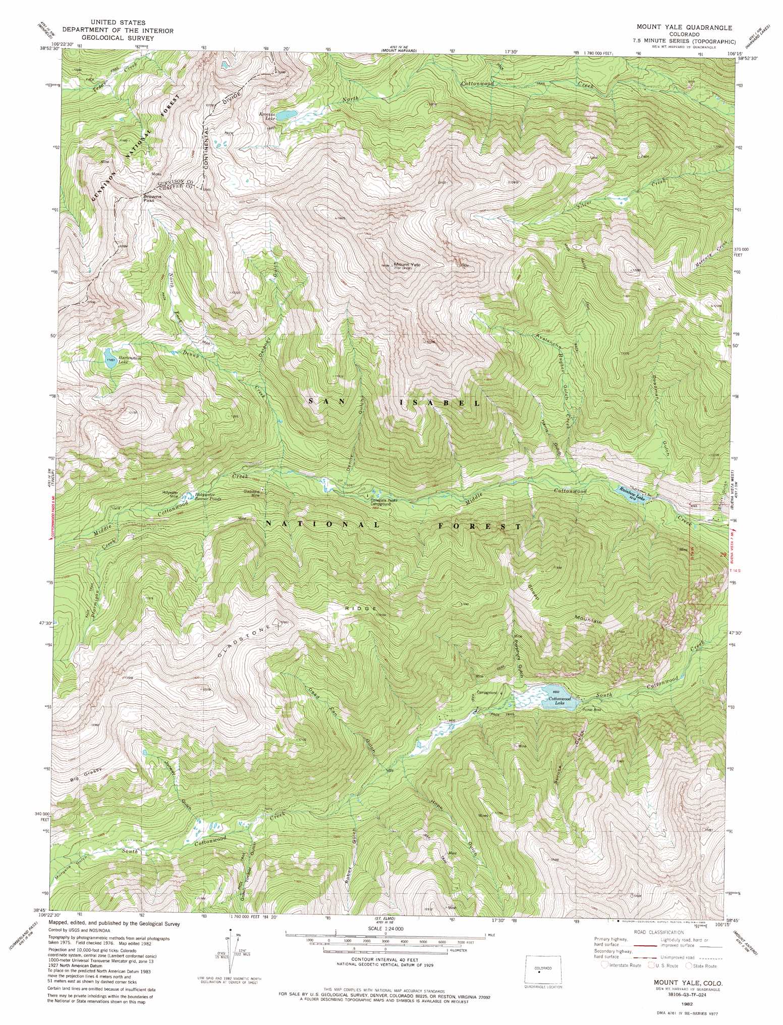
USGS Topo Quad 38106g3 - 1:24,000 scale
| Topo Map Name: | Mount Yale |
| USGS Topo Quad ID: | 38106g3 |
| Print Size: | ca. 21 1/4" wide x 27" high |
| Southeast Coordinates: | 38.75° N latitude / 106.25° W longitude |
| Map Center Coordinates: | 38.8125° N latitude / 106.3125° W longitude |
| U.S. State: | CO |
| Filename: | o38106g3.jpg |
| Download Map JPG Image: | Mount Yale topo map 1:24,000 scale |
| Map Type: | Topographic |
| Topo Series: | 7.5´ |
| Map Scale: | 1:24,000 |
| Source of Map Images: | United States Geological Survey (USGS) |
| Alternate Map Versions: |
Mount Yale CO 1982, updated 1983 Download PDF Buy paper map Mount Yale CO 1982, updated 1985 Download PDF Buy paper map Mount Yale CO 1994, updated 2001 Download PDF Buy paper map Mount Yale CO 2011 Download PDF Buy paper map Mount Yale CO 2013 Download PDF Buy paper map Mount Yale CO 2016 Download PDF Buy paper map |
| FStopo: | US Forest Service topo Mount Yale is available: Download FStopo PDF Download FStopo TIF |
1:24,000 Topo Quads surrounding Mount Yale
Independence Pass |
Mount Elbert |
Granite |
South Peak |
Jones Hill |
Pieplant |
Winfield |
Mount Harvard |
Harvard Lakes |
Marmot Peak |
Taylor Park Reservoir |
Tincup |
Mount Yale |
Buena Vista West |
Buena Vista East |
Fairview Peak |
Cumberland Pass |
Saint Elmo |
Mount Antero |
Nathrop |
Pitkin |
Whitepine |
Garfield |
Maysville |
Salida West |
> Back to 38106e1 at 1:100,000 scale
> Back to 38106a1 at 1:250,000 scale
> Back to U.S. Topo Maps home
Mount Yale topo map: Gazetteer
Mount Yale: Flats
Big Grassy elevation 3761m 12339′Mount Yale: Gaps
Browns Pass elevation 3657m 11998′Mount Yale: Lakes
Hartenstein Lake elevation 3306m 10846′Mount Yale: Mines
Browns Cabin Mine elevation 3659m 12004′Gladstone Mine elevation 3075m 10088′
Holywater Mine elevation 3173m 10410′
Longfellow Claim elevation 3069m 10068′
Mound Mine elevation 2914m 9560′
Mount Yale: Reservoirs
Cottonwood Lake elevation 2927m 9603′Fox Lake elevation 2935m 9629′
Holywater Beaver Ponds elevation 3129m 10265′
Kroenke Lake elevation 3510m 11515′
Rainbow Lake elevation 2812m 9225′
Mount Yale: Ridges
Gladstone Ridge elevation 3945m 12942′Mount Yale: Streams
Denny Creek elevation 3007m 9865′Horn Fork Creek elevation 3272m 10734′
Hughes Creek elevation 2828m 9278′
North Fork Denny Creek elevation 3298m 10820′
Ptarmigan Creek elevation 3191m 10469′
Mount Yale: Summits
Mount Yale elevation 4328m 14199′Sheep Mountain elevation 3612m 11850′
Mount Yale: Trails
Texas Creek Trail elevation 3274m 10741′Mount Yale: Valleys
Avalanche Gulch elevation 2851m 9353′Dead Can Gulch elevation 2975m 9760′
Deadman Gulch elevation 2837m 9307′
Delaney Gulch elevation 3189m 10462′
Denny Gulch elevation 2996m 9829′
Green Timber Gulch elevation 3151m 10337′
Harris Gulch elevation 2853m 9360′
Hope Gulch elevation 3395m 11138′
Jonesy Gulch elevation 3191m 10469′
Morgans Gulch elevation 3285m 10777′
Porphyry Gulch elevation 2922m 9586′
Robey Gulch elevation 3043m 9983′
Short Gulch elevation 2783m 9130′
Spruce Gulch elevation 2935m 9629′
Mount Yale digital topo map on disk
Buy this Mount Yale topo map showing relief, roads, GPS coordinates and other geographical features, as a high-resolution digital map file on DVD: