Pearl Pass Topo Map Colorado
To zoom in, hover over the map of Pearl Pass
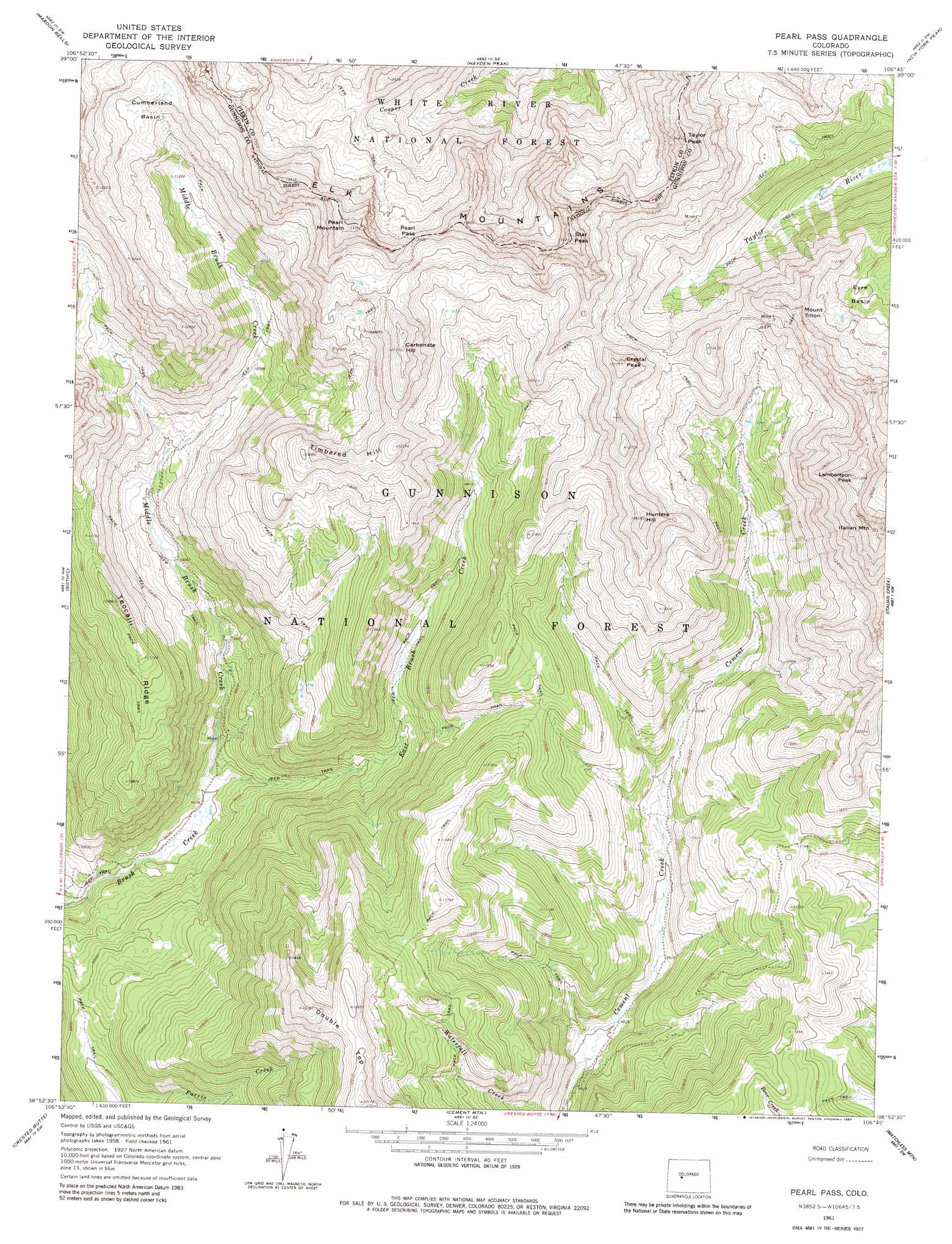
USGS Topo Quad 38106h7 - 1:24,000 scale
| Topo Map Name: | Pearl Pass |
| USGS Topo Quad ID: | 38106h7 |
| Print Size: | ca. 21 1/4" wide x 27" high |
| Southeast Coordinates: | 38.875° N latitude / 106.75° W longitude |
| Map Center Coordinates: | 38.9375° N latitude / 106.8125° W longitude |
| U.S. State: | CO |
| Filename: | o38106h7.jpg |
| Download Map JPG Image: | Pearl Pass topo map 1:24,000 scale |
| Map Type: | Topographic |
| Topo Series: | 7.5´ |
| Map Scale: | 1:24,000 |
| Source of Map Images: | United States Geological Survey (USGS) |
| Alternate Map Versions: |
Pearl Pass CO 1961, updated 1965 Download PDF Buy paper map Pearl Pass CO 1961, updated 1968 Download PDF Buy paper map Pearl Pass CO 1961, updated 1980 Download PDF Buy paper map Pearl Pass CO 2001, updated 2004 Download PDF Buy paper map Pearl Pass CO 2011 Download PDF Buy paper map Pearl Pass CO 2013 Download PDF Buy paper map Pearl Pass CO 2016 Download PDF Buy paper map |
| FStopo: | US Forest Service topo Pearl Pass is available: Download FStopo PDF Download FStopo TIF |
1:24,000 Topo Quads surrounding Pearl Pass
Capitol Peak |
Highland Peak |
Aspen |
Thimble Rock |
Mount Champion |
Snowmass Mountain |
Maroon Bells |
Hayden Peak |
New York Peak |
Independence Pass |
Oh-Be-Joyful |
Gothic |
Pearl Pass |
Italian Creek |
Pieplant |
Mount Axtell |
Crested Butte |
Cement Mountain |
Matchless Mountain |
Taylor Park Reservoir |
Squirrel Creek |
Flat Top |
Almont |
Crystal Creek |
Fairview Peak |
> Back to 38106e1 at 1:100,000 scale
> Back to 38106a1 at 1:250,000 scale
> Back to U.S. Topo Maps home
Pearl Pass topo map: Gazetteer
Pearl Pass: Basins
Cumberland Basin elevation 3643m 11952′Eyre Basin elevation 3539m 11610′
Pearl Pass: Gaps
Pearl Pass elevation 3875m 12713′Pearl Pass: Mines
Arrowhead Mine elevation 3765m 12352′Brush Creek Group Mine elevation 3325m 10908′
Clara L Mine elevation 3986m 13077′
Climax Mine elevation 3521m 11551′
Cooper Fork Deposit Mine elevation 3817m 12522′
Italian Mountain Mine elevation 3986m 13077′
Taylor Peak Mine elevation 3701m 12142′
Twenty Percent Creek Mine elevation 3529m 11578′
Pearl Pass: Ridges
Teocalli Ridge elevation 3445m 11302′Pearl Pass: Streams
East Brush Creek elevation 2866m 9402′Middle Brush Creek elevation 2866m 9402′
Pearl Pass: Summits
Carbonate Hill elevation 3867m 12687′Crystal Peak elevation 3654m 11988′
Double Top elevation 3713m 12181′
Greg Mace Peak elevation 3826m 12552′
Italian Mountain elevation 4023m 13198′
Lambertson Peak elevation 3949m 12956′
Mount Tilton elevation 3828m 12559′
Pearl Mountain elevation 4056m 13307′
Star Peak elevation 4112m 13490′
Taylor Peak elevation 4090m 13418′
Timbered Hill elevation 3773m 12378′
Pearl Pass digital topo map on disk
Buy this Pearl Pass topo map showing relief, roads, GPS coordinates and other geographical features, as a high-resolution digital map file on DVD: