Mount Sneffels Topo Map Colorado
To zoom in, hover over the map of Mount Sneffels
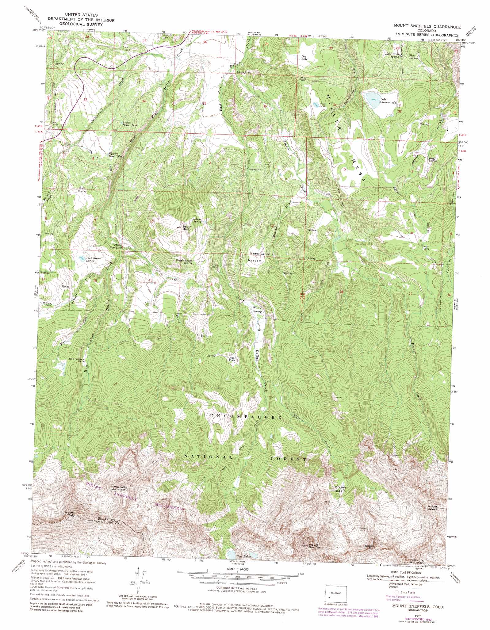
USGS Topo Quad 38107a7 - 1:24,000 scale
| Topo Map Name: | Mount Sneffels |
| USGS Topo Quad ID: | 38107a7 |
| Print Size: | ca. 21 1/4" wide x 27" high |
| Southeast Coordinates: | 38° N latitude / 107.75° W longitude |
| Map Center Coordinates: | 38.0625° N latitude / 107.8125° W longitude |
| U.S. State: | CO |
| Filename: | o38107a7.jpg |
| Download Map JPG Image: | Mount Sneffels topo map 1:24,000 scale |
| Map Type: | Topographic |
| Topo Series: | 7.5´ |
| Map Scale: | 1:24,000 |
| Source of Map Images: | United States Geological Survey (USGS) |
| Alternate Map Versions: |
Mount Sneffels CO 1967, updated 1971 Download PDF Buy paper map Mount Sneffels CO 1967, updated 1971 Download PDF Buy paper map Mount Sneffels CO 1967, updated 1974 Download PDF Buy paper map Mount Sneffels CO 1967, updated 1984 Download PDF Buy paper map Mount Sneffels CO 1967, updated 1987 Download PDF Buy paper map Mount Sneffels CO 2011 Download PDF Buy paper map Mount Sneffels CO 2013 Download PDF Buy paper map Mount Sneffels CO 2016 Download PDF Buy paper map |
| FStopo: | US Forest Service topo Mount Sneffels is available: Download FStopo PDF Download FStopo TIF |
1:24,000 Topo Quads surrounding Mount Sneffels
Pryor Creek |
Government Springs |
Colona |
Buckhorn Lakes |
Washboard Rock |
Hotchkiss Reservoir |
Horsefly Peak |
Ridgway |
Dallas |
Courthouse Mountain |
Placerville |
Sams |
Mount Sneffels |
Ouray |
Wetterhorn Peak |
Little Cone |
Gray Head |
Telluride |
Ironton |
Handies Peak |
Dolores Peak |
Mount Wilson |
Ophir |
Silverton |
Howardsville |
> Back to 38107a1 at 1:100,000 scale
> Back to 38106a1 at 1:250,000 scale
> Back to U.S. Topo Maps home
Mount Sneffels topo map: Gazetteer
Mount Sneffels: Basins
Blaine Basin elevation 3286m 10780′Mount Sneffels: Canals
Cannon Ditch elevation 2787m 9143′Ridgway Town Ditch elevation 2775m 9104′
Mount Sneffels: Dams
Carroll Brown Dam elevation 2748m 9015′Otonowanda Dam elevation 2607m 8553′
Mount Sneffels: Flats
Box Factory Park elevation 2832m 9291′Cocan Flats elevation 2921m 9583′
Elder Meadow elevation 2685m 8809′
Mount Sneffels: Lakes
Blue Lakes elevation 3534m 11594′Dry Lake elevation 2545m 8349′
West Lake elevation 2617m 8585′
Mount Sneffels: Mines
Blaine Mine elevation 3421m 11223′Ruby Trust Mine elevation 3287m 10784′
Mount Sneffels: Reservoirs
Carrol Brown Reservoir elevation 2748m 9015′Lake Otonawanda elevation 2607m 8553′
Lower Desert Tank elevation 2504m 8215′
Upper Desert Tank elevation 2562m 8405′
Mount Sneffels: Springs
Billy Wood Spring elevation 2502m 8208′Gibson Spring elevation 2827m 9274′
Groff Spring elevation 2618m 8589′
Homer Brown Spring elevation 2814m 9232′
Hout Spring elevation 2515m 8251′
Mud Spring elevation 2659m 8723′
Ulah Brown Spring elevation 2714m 8904′
Mount Sneffels: Streams
Beaver Creek elevation 2321m 7614′Cottonwood Creek elevation 2331m 7647′
Vance Creek elevation 2605m 8546′
West Fork West Dallas Creek elevation 2663m 8736′
Wilson Creek elevation 2798m 9179′
Mount Sneffels: Summits
Cirque Mountain elevation 4175m 13697′Mears Peak elevation 4097m 13441′
Miller Mesa elevation 2809m 9215′
Mount Ridgway elevation 4104m 13464′
Mount Sneffels elevation 4265m 13992′
South Baldy elevation 2993m 9819′
Teakettle Mountain elevation 4172m 13687′
Wolcott Mountain elevation 3971m 13028′
Mount Sneffels: Swamps
Willow Swamp elevation 2753m 9032′Mount Sneffels: Trails
Blue Lakes Trail elevation 3133m 10278′Dallas Trail elevation 2859m 9379′
Mount Sneffels: Valleys
Blaine Draw elevation 2493m 8179′Kettle Gulch elevation 2405m 7890′
Stough Draw elevation 2635m 8645′
Mount Sneffels digital topo map on disk
Buy this Mount Sneffels topo map showing relief, roads, GPS coordinates and other geographical features, as a high-resolution digital map file on DVD: