Alpine Plateau Topo Map Colorado
To zoom in, hover over the map of Alpine Plateau
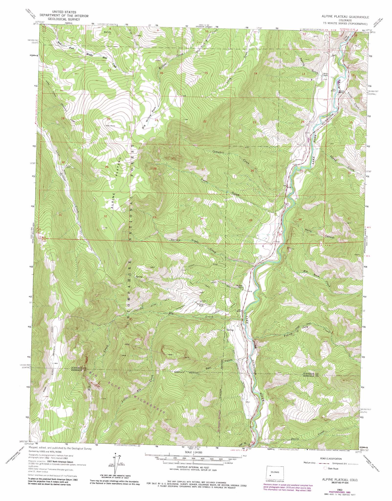
USGS Topo Quad 38107b3 - 1:24,000 scale
| Topo Map Name: | Alpine Plateau |
| USGS Topo Quad ID: | 38107b3 |
| Print Size: | ca. 21 1/4" wide x 27" high |
| Southeast Coordinates: | 38.125° N latitude / 107.25° W longitude |
| Map Center Coordinates: | 38.1875° N latitude / 107.3125° W longitude |
| U.S. State: | CO |
| Filename: | o38107b3.jpg |
| Download Map JPG Image: | Alpine Plateau topo map 1:24,000 scale |
| Map Type: | Topographic |
| Topo Series: | 7.5´ |
| Map Scale: | 1:24,000 |
| Source of Map Images: | United States Geological Survey (USGS) |
| Alternate Map Versions: |
Alpine Plateau CO 1963, updated 1966 Download PDF Buy paper map Alpine Plateau CO 1963, updated 1966 Download PDF Buy paper map Alpine Plateau CO 1963, updated 1972 Download PDF Buy paper map Alpine Plateau CO 2011 Download PDF Buy paper map Alpine Plateau CO 2013 Download PDF Buy paper map Alpine Plateau CO 2016 Download PDF Buy paper map |
| FStopo: | US Forest Service topo Alpine Plateau is available: Download FStopo PDF Download FStopo TIF |
1:24,000 Topo Quads surrounding Alpine Plateau
Cimarron |
Curecanti Needle |
Sapinero |
Carpenter Ridge |
Big Mesa |
Washboard Rock |
Lost Lake |
Poison Draw |
Gateview |
Powderhorn |
Courthouse Mountain |
Sheep Mountain |
Alpine Plateau |
Powderhorn Lakes |
Rudolph Hill |
Wetterhorn Peak |
Uncompahgre Peak |
Lake City |
Cannibal Plateau |
Mineral Mountain |
Handies Peak |
Redcloud Peak |
Lake San Cristobal |
Slumgullion Pass |
Baldy Cinco |
> Back to 38107a1 at 1:100,000 scale
> Back to 38106a1 at 1:250,000 scale
> Back to U.S. Topo Maps home
Alpine Plateau topo map: Gazetteer
Alpine Plateau: Canals
Copeland Elk Creek Ditch elevation 2614m 8576′Thompson Ditch elevation 2704m 8871′
Thompson Ditch Number 2 elevation 2820m 9251′
Youman Ditch elevation 2614m 8576′
Alpine Plateau: Flats
Big Willow Park elevation 3447m 11309′Alpine Plateau: Gaps
The Gate elevation 2444m 8018′Alpine Plateau: Mines
Ferrara Ranch Mine elevation 2900m 9514′Alpine Plateau: Streams
Big Buck Creek elevation 2489m 8166′Campbell Creek elevation 2476m 8123′
Devils Creek elevation 2553m 8375′
Elk Creek elevation 2513m 8244′
Fourth of July Creek elevation 2518m 8261′
Little Elk Creek elevation 2678m 8786′
Narrow Grade Creek elevation 2503m 8211′
Skunk Creek elevation 2461m 8074′
Trout Creek elevation 2447m 8028′
Alpine Plateau: Summits
Alpine Plateau elevation 3509m 11512′Baldy elevation 3387m 11112′
Alpine Plateau: Trails
Ridge Stock Driveway elevation 3683m 12083′Alpine Plateau: Valleys
Dwyer Gulch elevation 2512m 8241′Hells Canyon elevation 2521m 8270′
High Bridge Gulch elevation 2559m 8395′
Spring Gulch elevation 2443m 8015′
Well Gulch elevation 2520m 8267′
Alpine Plateau digital topo map on disk
Buy this Alpine Plateau topo map showing relief, roads, GPS coordinates and other geographical features, as a high-resolution digital map file on DVD: