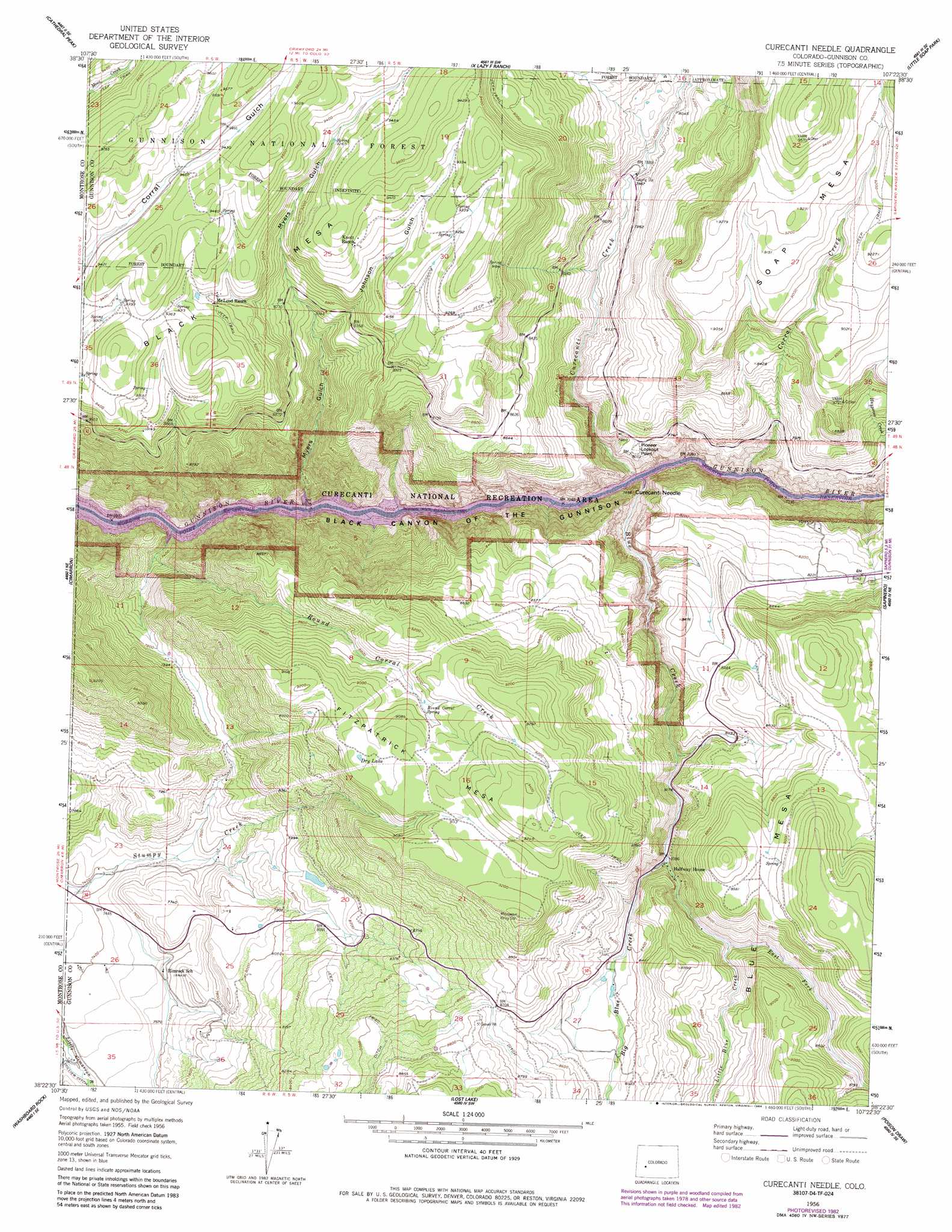
Curecanti Needle Topo Map Colorado
To zoom in, hover over the map of Curecanti Needle
USGS Topo Quad 38107d4 - 1:24,000 scale
| Topo Map Name: | Curecanti Needle |
| USGS Topo Quad ID: | 38107d4 |
| Print Size: | ca. 21 1/4" wide x 27" high |
| Southeast Coordinates: | 38.375° N latitude / 107.375° W longitude |
| Map Center Coordinates: | 38.4375° N latitude / 107.4375° W longitude |
| U.S. State: | CO |
| Filename: | o38107d4.jpg |
| Download Map JPG Image: | Curecanti Needle topo map 1:24,000 scale |
| Map Type: | Topographic |
| Topo Series: | 7.5´ |
| Map Scale: | 1:24,000 |
| Source of Map Images: | United States Geological Survey (USGS) |
| Alternate Map Versions: |
Curecanti Needle CO 1956, updated 1957 Download PDF Buy paper map Curecanti Needle CO 1956, updated 1963 Download PDF Buy paper map Curecanti Needle CO 1956, updated 1984 Download PDF Buy paper map Curecanti Needle CO 1956, updated 1984 Download PDF Buy paper map Curecanti Needle CO 2001, updated 2004 Download PDF Buy paper map Curecanti Needle CO 2011 Download PDF Buy paper map Curecanti Needle CO 2013 Download PDF Buy paper map Curecanti Needle CO 2016 Download PDF Buy paper map |
| FStopo: | US Forest Service topo Curecanti Needle is available: Download FStopo PDF Download FStopo TIF |
1:24,000 Topo Quads surrounding Curecanti Needle
Grand View Mesa |
Crawford |
Mount Guero |
Big Soap Park |
West Elk Peak |
Grizzly Ridge |
Cathedral Peak |
X Lazy F Ranch |
Little Soap Park |
West Elk Peak Sw |
Cerro Summit |
Cimarron |
Curecanti Needle |
Sapinero |
Carpenter Ridge |
Buckhorn Lakes |
Washboard Rock |
Lost Lake |
Poison Draw |
Gateview |
Dallas |
Courthouse Mountain |
Sheep Mountain |
Alpine Plateau |
Powderhorn Lakes |
> Back to 38107a1 at 1:100,000 scale
> Back to 38106a1 at 1:250,000 scale
> Back to U.S. Topo Maps home
Curecanti Needle topo map: Gazetteer
Curecanti Needle: Airports
Fitzpatrick Heliport elevation 2564m 8412′Curecanti Needle: Canals
Big Blue Ditch elevation 2659m 8723′Curecanti Needle: Cliffs
Pioneer Lookout Point elevation 2449m 8034′Curecanti Needle: Lakes
Dry Lake elevation 2777m 9110′Curecanti Needle: Mines
Black Mesa Lode Mine elevation 2491m 8172′Blue Creek District Mine elevation 2476m 8123′
Last Chance Mine elevation 2498m 8195′
Curecanti Needle: Parks
Curecanti National Recreation Area elevation 2380m 7808′Curecanti Needle: Pillars
Curecanti Needle elevation 2359m 7739′Curecanti Needle: Springs
Round Corral Spring elevation 2727m 8946′Curecanti Needle: Streams
Big Blue Creek elevation 2184m 7165′Blue Creek elevation 2423m 7949′
Corral Creek elevation 2184m 7165′
Curecanti Creek elevation 2184m 7165′
East Fork Little Blue Creek elevation 2536m 8320′
Haypress Creek elevation 2192m 7191′
Little Blue Creek elevation 2492m 8175′
Round Corral Creek elevation 2184m 7165′
Curecanti Needle: Summits
Blue Mesa elevation 2831m 9288′Fitzpatrick Mesa elevation 2867m 9406′
Curecanti Needle: Valleys
Johnson Gulch elevation 2831m 9288′Myers Gulch elevation 2184m 7165′
Curecanti Needle digital topo map on disk
Buy this Curecanti Needle topo map showing relief, roads, GPS coordinates and other geographical features, as a high-resolution digital map file on DVD: