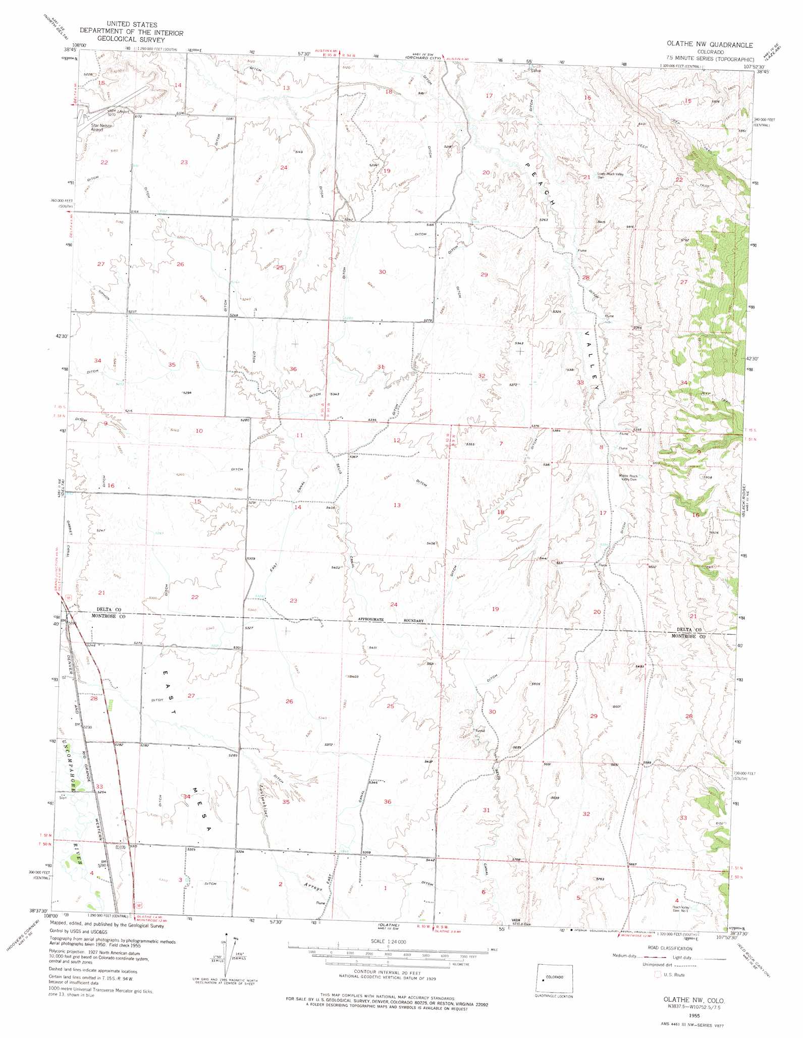
Olathe Nw Topo Map Colorado
To zoom in, hover over the map of Olathe Nw
USGS Topo Quad 38107f8 - 1:24,000 scale
| Topo Map Name: | Olathe Nw |
| USGS Topo Quad ID: | 38107f8 |
| Print Size: | ca. 21 1/4" wide x 27" high |
| Southeast Coordinates: | 38.625° N latitude / 107.875° W longitude |
| Map Center Coordinates: | 38.6875° N latitude / 107.9375° W longitude |
| U.S. State: | CO |
| Filename: | o38107f8.jpg |
| Download Map JPG Image: | Olathe Nw topo map 1:24,000 scale |
| Map Type: | Topographic |
| Topo Series: | 7.5´ |
| Map Scale: | 1:24,000 |
| Source of Map Images: | United States Geological Survey (USGS) |
| Alternate Map Versions: |
Olathe NW CO 1955, updated 1956 Download PDF Buy paper map Olathe NW CO 1955, updated 1956 Download PDF Buy paper map Olathe NW CO 1955, updated 1969 Download PDF Buy paper map Olathe NW CO 1955, updated 1969 Download PDF Buy paper map Olathe NW CO 1955, updated 1975 Download PDF Buy paper map Olathe NW CO 2010 Download PDF Buy paper map Olathe NW CO 2013 Download PDF Buy paper map Olathe NW CO 2016 Download PDF Buy paper map |
1:24,000 Topo Quads surrounding Olathe Nw
Indian Point |
Hells Kitchen |
Cedaredge |
Dry Creek |
Gray Reservoir |
Point Creek |
North Delta |
Orchard City |
Lazear |
Hotchkiss |
Roubideau |
Delta |
Olathe Nw |
Black Ridge |
Grand View Mesa |
Camel Back |
Hoovers Corner |
Olathe |
Red Rock Canyon |
Grizzly Ridge |
Davis Point |
Dry Creek Basin |
Montrose West |
Montrose East |
Cerro Summit |
> Back to 38107e1 at 1:100,000 scale
> Back to 38106a1 at 1:250,000 scale
> Back to U.S. Topo Maps home
Olathe Nw topo map: Gazetteer
Olathe Nw: Airports
Star Nelson Airport elevation 1605m 5265′Olathe Nw: Canals
East Canal elevation 1625m 5331′Olathe Nw: Dams
Lower Peach Valley Dam elevation 1622m 5321′Middle Peach Valley Dam elevation 1660m 5446′
Peach Valley Dam Number 1 elevation 1758m 5767′
Olathe Nw: Mines
Iron Cap Mine elevation 1748m 5734′Olathe Nw digital topo map on disk
Buy this Olathe Nw topo map showing relief, roads, GPS coordinates and other geographical features, as a high-resolution digital map file on DVD: