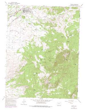
Paonia Topo Map Colorado
To zoom in, hover over the map of Paonia
USGS Topo Quad 38107g5 - 1:24,000 scale
| Topo Map Name: | Paonia |
| USGS Topo Quad ID: | 38107g5 |
| Print Size: | ca. 21 1/4" wide x 27" high |
| Southeast Coordinates: | 38.75° N latitude / 107.5° W longitude |
| Map Center Coordinates: | 38.8125° N latitude / 107.5625° W longitude |
| U.S. State: | CO |
| Filename: | o38107g5.jpg |
| Download Map JPG Image: | Paonia topo map 1:24,000 scale |
| Map Type: | Topographic |
| Topo Series: | 7.5´ |
| Map Scale: | 1:24,000 |
| Source of Map Images: | United States Geological Survey (USGS) |
| Alternate Map Versions: |
Paonia CO 1965, updated 1968 Download PDF Buy paper map Paonia CO 1965, updated 1968 Download PDF Buy paper map Paonia CO 1965, updated 1975 Download PDF Buy paper map Paonia CO 1965, updated 1985 Download PDF Buy paper map Paonia CO 2001, updated 2004 Download PDF Buy paper map Paonia CO 2011 Download PDF Buy paper map Paonia CO 2013 Download PDF Buy paper map Paonia CO 2016 Download PDF Buy paper map |
| FStopo: | US Forest Service topo Paonia is available: Download FStopo PDF Download FStopo TIF |
1:24,000 Topo Quads surrounding Paonia
> Back to 38107e1 at 1:100,000 scale
> Back to 38106a1 at 1:250,000 scale
> Back to U.S. Topo Maps home
Paonia topo map: Gazetteer
Paonia: Canals
Minnesota Ditch elevation 1815m 5954′Needle Rock Ditch elevation 1852m 6076′
Stewart Ditch elevation 1749m 5738′
Turner Ditch elevation 1898m 6227′
Paonia: Dams
Lone Cabin Dam elevation 2244m 7362′Reynolds Dam elevation 2139m 7017′
Todd Dam elevation 2312m 7585′
Todd Dam elevation 2291m 7516′
Paonia: Gaps
Inter-Ocean Pass elevation 2978m 9770′Paonia: Parks
Northfork Miners Memorial elevation 1727m 5666′Paonia Park elevation 1726m 5662′
Paonia: Populated Places
Paonia elevation 1732m 5682′Paonia: Post Offices
Paonia Post Office elevation 1721m 5646′Paonia: Reservoirs
Inter-Ocean Reservoir elevation 2356m 7729′Lone Cabin Reservoir elevation 2244m 7362′
Reynolds Reservoir elevation 2139m 7017′
Roeber Reservoir elevation 2128m 6981′
Todd Reservoir elevation 2312m 7585′
Paonia: Ridges
Sams Divide elevation 2319m 7608′Paonia: Springs
Bell Creek Springs elevation 2203m 7227′Clark Spring Number 1 elevation 2225m 7299′
Clark Spring Number 2 elevation 2292m 7519′
Corral Spring Number 1 elevation 2181m 7155′
Corral Spring Number 2 elevation 2190m 7185′
German Creek Springs elevation 2269m 7444′
Kauer Spring elevation 2208m 7244′
Mays Spring elevation 2191m 7188′
Pole Patch Springs elevation 2335m 7660′
Reynolds Creek Springs elevation 2237m 7339′
Stephens Spring elevation 2178m 7145′
Upper Reynolds Creek Spring Number 1 elevation 2327m 7634′
Upper Reynolds Creek Spring Number 2 elevation 2314m 7591′
Upper Reynolds Creek Spring Number 3 elevation 2377m 7798′
Upper Reynolds Creek Spring Number 4 elevation 2328m 7637′
Upper Reynolds Creek Spring Number 5 elevation 2270m 7447′
Upper Reynolds Creek Spring Number 6 elevation 2244m 7362′
Upper Reynolds Creek Spring Number 7 elevation 2232m 7322′
Upper Reynolds Creek Springs elevation 2373m 7785′
Wiley Springs elevation 2284m 7493′
Paonia: Streams
Dry Fork Minnesota Creek elevation 1933m 6341′German Creek elevation 1706m 5597′
Lucas Creek elevation 1781m 5843′
Miller Creek elevation 1770m 5807′
Roatcap Creek elevation 1698m 5570′
Paonia: Summits
Bone Mesa elevation 1783m 5849′Cedar Hill elevation 1881m 6171′
Elephant Hill elevation 2149m 7050′
Lamborn Mesa elevation 1859m 6099′
Landsend Peak elevation 3297m 10816′
McDonald Mesa elevation 2168m 7112′
Mount Lamborn elevation 3474m 11397′
Stewart Mesa elevation 1747m 5731′
Paonia: Valleys
Dry Gulch elevation 1785m 5856′Paonia digital topo map on disk
Buy this Paonia topo map showing relief, roads, GPS coordinates and other geographical features, as a high-resolution digital map file on DVD:


