Lazear Topo Map Colorado
To zoom in, hover over the map of Lazear
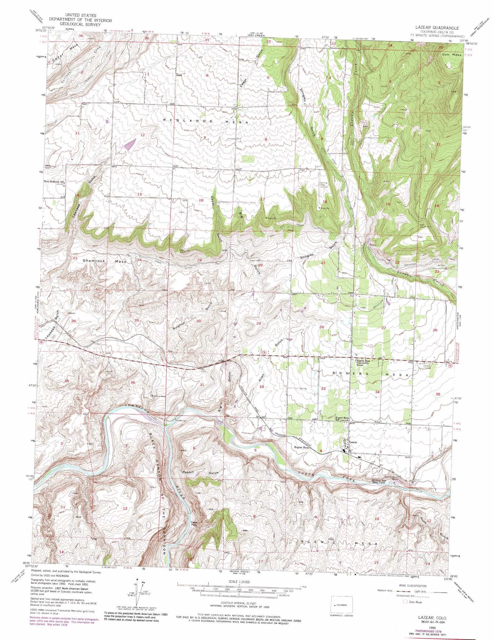
USGS Topo Quad 38107g7 - 1:24,000 scale
| Topo Map Name: | Lazear |
| USGS Topo Quad ID: | 38107g7 |
| Print Size: | ca. 21 1/4" wide x 27" high |
| Southeast Coordinates: | 38.75° N latitude / 107.75° W longitude |
| Map Center Coordinates: | 38.8125° N latitude / 107.8125° W longitude |
| U.S. State: | CO |
| Filename: | o38107g7.jpg |
| Download Map JPG Image: | Lazear topo map 1:24,000 scale |
| Map Type: | Topographic |
| Topo Series: | 7.5´ |
| Map Scale: | 1:24,000 |
| Source of Map Images: | United States Geological Survey (USGS) |
| Alternate Map Versions: |
Lazear CO 1955, updated 1957 Download PDF Buy paper map Lazear CO 1955, updated 1957 Download PDF Buy paper map Lazear CO 1955, updated 1967 Download PDF Buy paper map Lazear CO 1955, updated 1967 Download PDF Buy paper map Lazear CO 1955, updated 1975 Download PDF Buy paper map Lazear CO 1955, updated 1979 Download PDF Buy paper map Lazear CO 1955, updated 1985 Download PDF Buy paper map Lazear CO 1955, updated 1985 Download PDF Buy paper map Lazear CO 2010 Download PDF Buy paper map Lazear CO 2013 Download PDF Buy paper map Lazear CO 2016 Download PDF Buy paper map |
1:24,000 Topo Quads surrounding Lazear
Mesa Lakes |
Grand Mesa |
Leon Peak |
Chalk Mountain |
Electric Mountain |
Hells Kitchen |
Cedaredge |
Dry Creek |
Gray Reservoir |
Bowie |
North Delta |
Orchard City |
Lazear |
Hotchkiss |
Paonia |
Delta |
Olathe Nw |
Black Ridge |
Grand View Mesa |
Crawford |
Hoovers Corner |
Olathe |
Red Rock Canyon |
Grizzly Ridge |
Cathedral Peak |
> Back to 38107e1 at 1:100,000 scale
> Back to 38106a1 at 1:250,000 scale
> Back to U.S. Topo Maps home
Lazear topo map: Gazetteer
Lazear: Airports
Flying W Ranch Airport elevation 2035m 6676′Kramer Ranch Airport elevation 1873m 6145′
Redlands Airport elevation 1927m 6322′
Shipman Ranch Airport elevation 1879m 6164′
Lazear: Canals
Durkee Ditch elevation 1877m 6158′Highline Ditch elevation 1935m 6348′
Oasis Ditch elevation 1759m 5770′
Lazear: Dams
Paulson Dam elevation 1921m 6302′Lazear: Flats
Cedar Flats elevation 1573m 5160′Lazear: Mines
Gunnison Forks Mine elevation 1592m 5223′Sulphur Mine elevation 1586m 5203′
Lazear: Populated Places
Lazear elevation 1660m 5446′Rogers Mesa elevation 1654m 5426′
Lazear: Post Offices
Lazear Post Office elevation 1658m 5439′Lazear: Reservoirs
Paulson Reservoir elevation 1921m 6302′Lazear: Springs
Tommy Dowell Spring elevation 1628m 5341′Lazear: Streams
North Fork Gunnison River elevation 1551m 5088′Lazear: Summits
Redlands Mesa elevation 2011m 6597′Rogers Mesa elevation 1716m 5629′
Scenic Mesa elevation 1738m 5702′
Shamrock Mesa elevation 1726m 5662′
Lazear: Valleys
Allen Gulch elevation 1561m 5121′Alum Gulch elevation 1589m 5213′
Big Gulch elevation 1561m 5121′
Black Canyon of the Gunnison elevation 1554m 5098′
Cedar Gulch elevation 1713m 5620′
Rabbit Gulch elevation 1554m 5098′
Stingley Gulch elevation 1723m 5652′
Sulphur Gulch elevation 1560m 5118′
Lazear digital topo map on disk
Buy this Lazear topo map showing relief, roads, GPS coordinates and other geographical features, as a high-resolution digital map file on DVD: