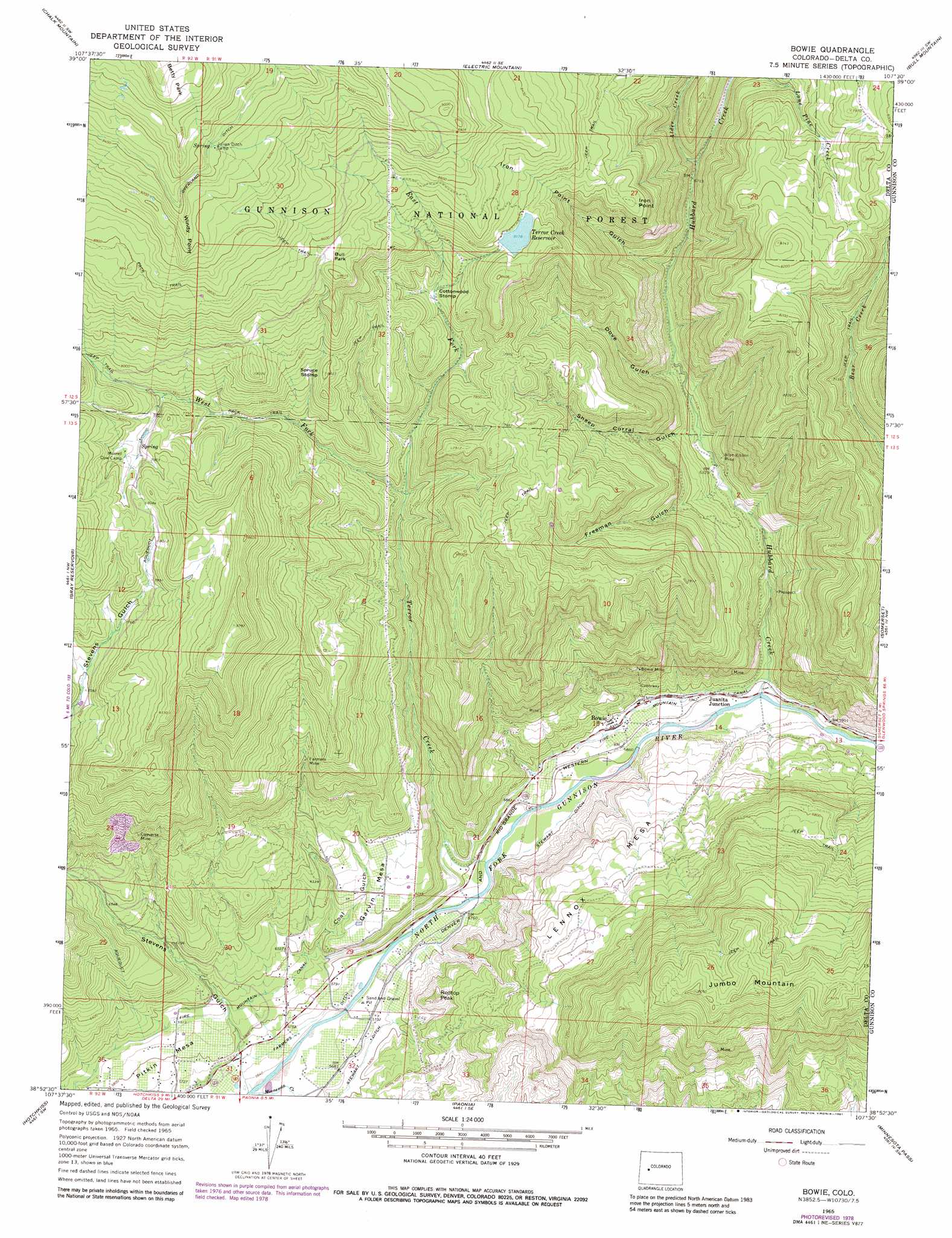
Bowie Topo Map Colorado
To zoom in, hover over the map of Bowie
USGS Topo Quad 38107h5 - 1:24,000 scale
| Topo Map Name: | Bowie |
| USGS Topo Quad ID: | 38107h5 |
| Print Size: | ca. 21 1/4" wide x 27" high |
| Southeast Coordinates: | 38.875° N latitude / 107.5° W longitude |
| Map Center Coordinates: | 38.9375° N latitude / 107.5625° W longitude |
| U.S. State: | CO |
| Filename: | o38107h5.jpg |
| Download Map JPG Image: | Bowie topo map 1:24,000 scale |
| Map Type: | Topographic |
| Topo Series: | 7.5´ |
| Map Scale: | 1:24,000 |
| Source of Map Images: | United States Geological Survey (USGS) |
| Alternate Map Versions: |
Bowie CO 1965, updated 1968 Download PDF Buy paper map Bowie CO 1965, updated 1968 Download PDF Buy paper map Bowie CO 1965, updated 1971 Download PDF Buy paper map Bowie CO 1965, updated 1971 Download PDF Buy paper map Bowie CO 1965, updated 1979 Download PDF Buy paper map Bowie CO 1965, updated 1981 Download PDF Buy paper map Bowie CO 2001, updated 2004 Download PDF Buy paper map Bowie CO 2011 Download PDF Buy paper map Bowie CO 2013 Download PDF Buy paper map Bowie CO 2016 Download PDF Buy paper map |
| FStopo: | US Forest Service topo Bowie is available: Download FStopo PDF Download FStopo TIF |
1:24,000 Topo Quads surrounding Bowie
The Meadows |
Porter Mountain |
Spruce Mountain |
Elk Knob |
Placita |
Leon Peak |
Chalk Mountain |
Electric Mountain |
Bull Mountain |
Chair Mountain |
Dry Creek |
Gray Reservoir |
Bowie |
Somerset |
Paonia Reservoir |
Lazear |
Hotchkiss |
Paonia |
Minnesota Pass |
West Beckwith Mountain |
Black Ridge |
Grand View Mesa |
Crawford |
Mount Guero |
Big Soap Park |
> Back to 38107e1 at 1:100,000 scale
> Back to 38106a1 at 1:250,000 scale
> Back to U.S. Topo Maps home
Bowie topo map: Gazetteer
Bowie: Cliffs
Iron Point elevation 2467m 8093′Windy Point elevation 2797m 9176′
Bowie: Dams
Bruce Park Dam elevation 2528m 8293′Bowie: Flats
Betty Park elevation 3063m 10049′Bull Park elevation 2608m 8556′
Cottonwood Stomp elevation 2333m 7654′
Spruce Stomp elevation 2396m 7860′
Bowie: Mines
Blue Ribbon Mine elevation 1997m 6551′Bowie Mine elevation 2042m 6699′
Converse Mine elevation 2180m 7152′
Farmers Mine elevation 2130m 6988′
Orchard Valley Mine elevation 2143m 7030′
Bowie: Populated Places
Bowie elevation 1818m 5964′Juanita Junction elevation 1805m 5921′
Bowie: Reservoirs
Bruce Park Reservoir elevation 2528m 8293′Pothole Reservoir Number 2 elevation 2482m 8143′
Terror Creek Reservoir elevation 2494m 8182′
Bowie: Streams
Alder Creek elevation 2054m 6738′East Fork Terror Creek elevation 2160m 7086′
Hubbard Creek elevation 1790m 5872′
Minnesota Creek elevation 1720m 5643′
Terror Creek elevation 1809m 5935′
Terror Ditch elevation 2494m 8182′
West Fork Terror Creek elevation 2158m 7080′
Bowie: Summits
Garvin Mesa elevation 1904m 6246′Jumbo Mountain elevation 2488m 8162′
Lennox Mesa elevation 1999m 6558′
Pitkin Mesa elevation 1801m 5908′
Redtop Peak elevation 1917m 6289′
Bowie: Valleys
Coal Gulch elevation 1802m 5912′Dove Gulch elevation 1980m 6496′
Freeman Gulch elevation 1979m 6492′
Iron Point Gulch elevation 1989m 6525′
Sheep Corral Gulch elevation 1957m 6420′
Stevens Gulch elevation 1749m 5738′
Bowie digital topo map on disk
Buy this Bowie topo map showing relief, roads, GPS coordinates and other geographical features, as a high-resolution digital map file on DVD: