Gray Reservoir Topo Map Colorado
To zoom in, hover over the map of Gray Reservoir
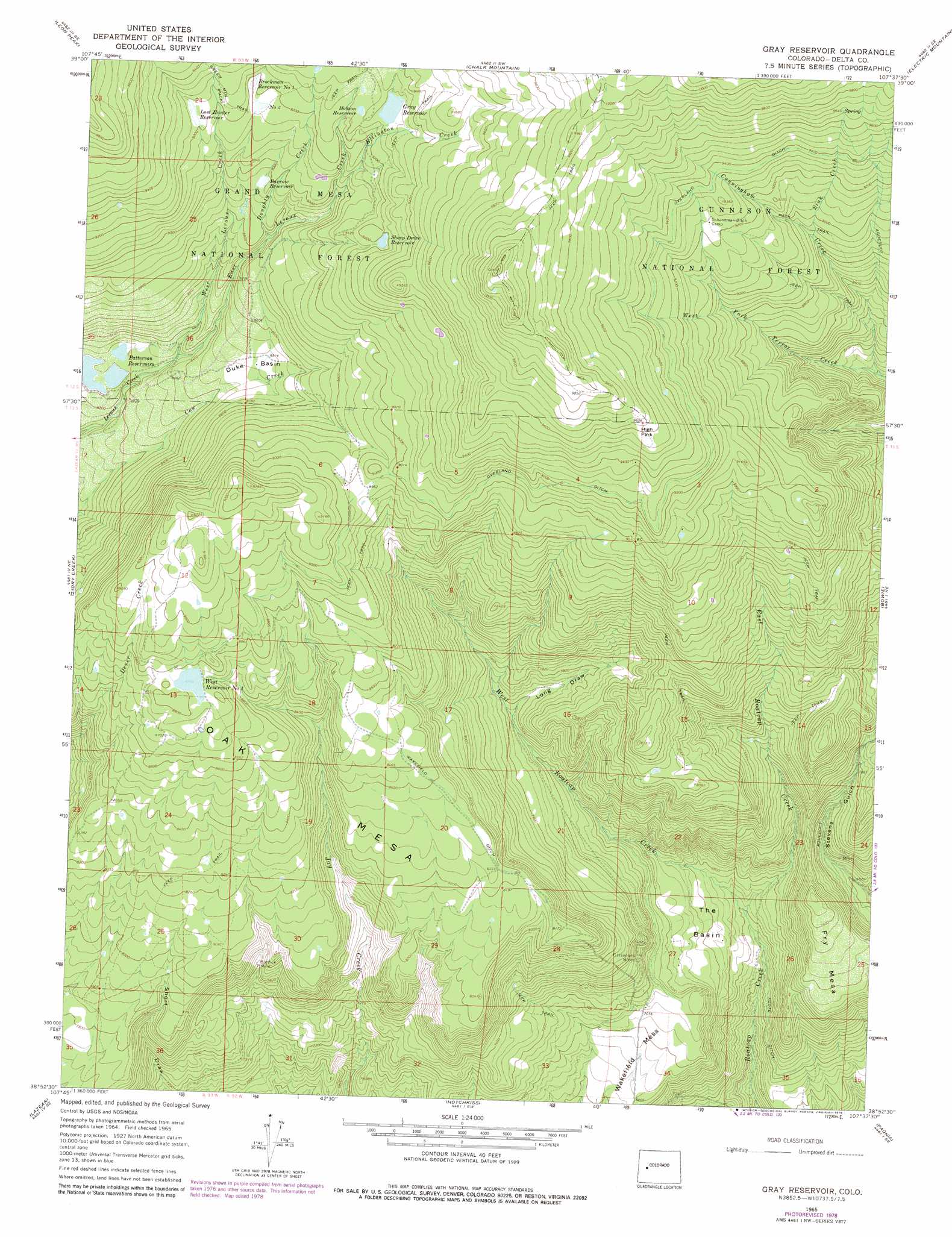
USGS Topo Quad 38107h6 - 1:24,000 scale
| Topo Map Name: | Gray Reservoir |
| USGS Topo Quad ID: | 38107h6 |
| Print Size: | ca. 21 1/4" wide x 27" high |
| Southeast Coordinates: | 38.875° N latitude / 107.625° W longitude |
| Map Center Coordinates: | 38.9375° N latitude / 107.6875° W longitude |
| U.S. State: | CO |
| Filename: | o38107h6.jpg |
| Download Map JPG Image: | Gray Reservoir topo map 1:24,000 scale |
| Map Type: | Topographic |
| Topo Series: | 7.5´ |
| Map Scale: | 1:24,000 |
| Source of Map Images: | United States Geological Survey (USGS) |
| Alternate Map Versions: |
Gray Reservoir CO 1965, updated 1968 Download PDF Buy paper map Gray Reservoir CO 1965, updated 1968 Download PDF Buy paper map Gray Reservoir CO 1965, updated 1975 Download PDF Buy paper map Gray Reservoir CO 1965, updated 1979 Download PDF Buy paper map Gray Reservoir CO 2011 Download PDF Buy paper map Gray Reservoir CO 2013 Download PDF Buy paper map Gray Reservoir CO 2016 Download PDF Buy paper map |
| FStopo: | US Forest Service topo Gray Reservoir is available: Download FStopo PDF Download FStopo TIF |
1:24,000 Topo Quads surrounding Gray Reservoir
Collbran |
The Meadows |
Porter Mountain |
Spruce Mountain |
Elk Knob |
Grand Mesa |
Leon Peak |
Chalk Mountain |
Electric Mountain |
Bull Mountain |
Cedaredge |
Dry Creek |
Gray Reservoir |
Bowie |
Somerset |
Orchard City |
Lazear |
Hotchkiss |
Paonia |
Minnesota Pass |
Olathe Nw |
Black Ridge |
Grand View Mesa |
Crawford |
Mount Guero |
> Back to 38107e1 at 1:100,000 scale
> Back to 38106a1 at 1:250,000 scale
> Back to U.S. Topo Maps home
Gray Reservoir topo map: Gazetteer
Gray Reservoir: Basins
Duke Basin elevation 2597m 8520′The Basin elevation 2073m 6801′
Gray Reservoir: Canals
Foote Ditch elevation 1971m 6466′Overland Ditch elevation 2775m 9104′
Wakefield Ditch elevation 2537m 8323′
Gray Reservoir: Dams
Brockman Number 1 Dam elevation 2804m 9199′Brockman Number 2 Dam elevation 2795m 9169′
Gray Dam elevation 2830m 9284′
Patterson Number 2 Dam elevation 2513m 8244′
West Number 1 Dam elevation 2673m 8769′
Gray Reservoir: Flats
High Park elevation 2941m 9648′Gray Reservoir: Mines
Burdick Mine elevation 2317m 7601′Delta W Mine elevation 2253m 7391′
Fitzsimons Mines elevation 2249m 7378′
Gray Reservoir: Reservoirs
Barrow Reservoir elevation 2721m 8927′Brockman Reservoir Number 1 elevation 2804m 9199′
Brockman Reservoir Number 2 elevation 2795m 9169′
Gray Reservoir elevation 2833m 9294′
Hobson Reservoir elevation 2841m 9320′
Lost Hunter Reservoir elevation 2806m 9206′
Patterson Reservoir Number 2 elevation 2513m 8244′
Patterson Reservoirs elevation 2513m 8244′
Sheep Drive Reservoir elevation 2804m 9199′
West Reservoir Number One elevation 2673m 8769′
Gray Reservoir: Streams
Cunningham Creek elevation 2449m 8034′Doughty Creek elevation 2649m 8690′
East Leroux Creek elevation 2535m 8316′
East Roatcap Creek elevation 2010m 6594′
Ellington Creek elevation 2728m 8950′
Sink Creek elevation 2702m 8864′
West Leroux Creek elevation 2535m 8316′
West Roatcap Creek elevation 2010m 6594′
Gray Reservoir: Summits
Fry Mesa elevation 2284m 7493′Oak Mesa elevation 2650m 8694′
Wakefield Mesa elevation 2156m 7073′
Gray Reservoir: Valleys
Long Draw elevation 2305m 7562′Gray Reservoir digital topo map on disk
Buy this Gray Reservoir topo map showing relief, roads, GPS coordinates and other geographical features, as a high-resolution digital map file on DVD: