Horse Range Mesa Topo Map Colorado
To zoom in, hover over the map of Horse Range Mesa
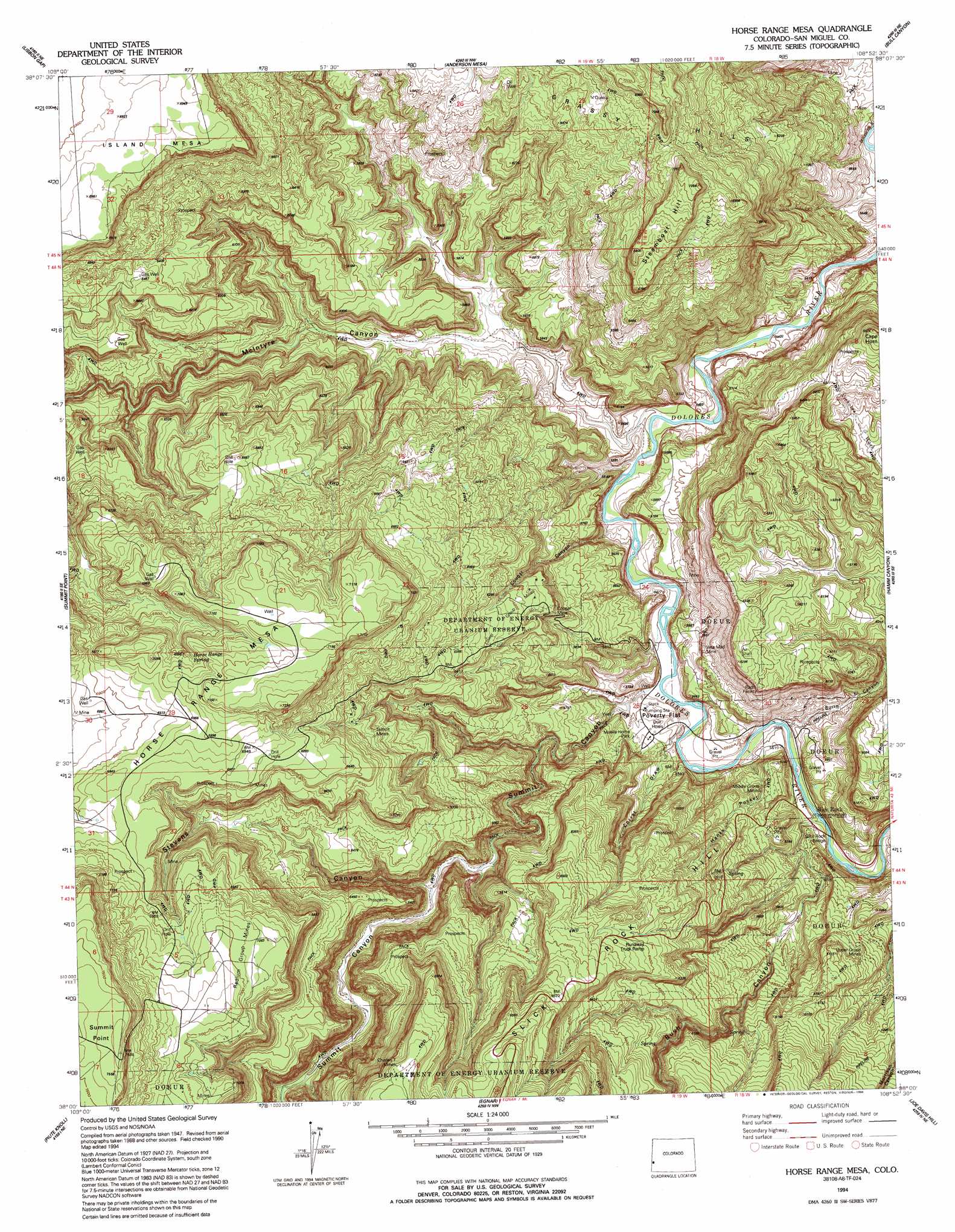
USGS Topo Quad 38108a8 - 1:24,000 scale
| Topo Map Name: | Horse Range Mesa |
| USGS Topo Quad ID: | 38108a8 |
| Print Size: | ca. 21 1/4" wide x 27" high |
| Southeast Coordinates: | 38° N latitude / 108.875° W longitude |
| Map Center Coordinates: | 38.0625° N latitude / 108.9375° W longitude |
| U.S. State: | CO |
| Filename: | o38108a8.jpg |
| Download Map JPG Image: | Horse Range Mesa topo map 1:24,000 scale |
| Map Type: | Topographic |
| Topo Series: | 7.5´ |
| Map Scale: | 1:24,000 |
| Source of Map Images: | United States Geological Survey (USGS) |
| Alternate Map Versions: |
Horse Range Mesa CO 1948, updated 1955 Download PDF Buy paper map Horse Range Mesa CO 1950 Download PDF Buy paper map Horse Range Mesa CO 1950 Download PDF Buy paper map Horse Range Mesa CO 1960, updated 1961 Download PDF Buy paper map Horse Range Mesa CO 1960, updated 1961 Download PDF Buy paper map Horse Range Mesa CO 1994, updated 1994 Download PDF Buy paper map Horse Range Mesa CO 2011 Download PDF Buy paper map Horse Range Mesa CO 2013 Download PDF Buy paper map Horse Range Mesa CO 2016 Download PDF Buy paper map |
1:24,000 Topo Quads surrounding Horse Range Mesa
La Sal East |
Wray Mesa |
Paradox |
Davis Mesa |
Uravan |
Lisbon Valley |
Lisbon Gap |
Anderson Mesa |
Bull Canyon |
Naturita Nw |
Sop Canyon |
Summit Point |
Horse Range Mesa |
Hamm Canyon |
Gypsum Gap |
Eastland Nw |
Piute Point |
Egnar |
Joe Davis Hill |
Dawson Draw |
Eastland |
Northdale |
Dove Creek |
Secret Canyon |
The Glade |
> Back to 38108a1 at 1:100,000 scale
> Back to 38108a1 at 1:250,000 scale
> Back to U.S. Topo Maps home
Horse Range Mesa topo map: Gazetteer
Horse Range Mesa: Bridges
Slick Rock Bridge elevation 1662m 5452′Horse Range Mesa: Cliffs
Summit Point elevation 2306m 7565′Horse Range Mesa: Flats
Poverty Flat elevation 1689m 5541′Horse Range Mesa: Mines
A H Canfield Mine elevation 2178m 7145′Alice Mine elevation 1904m 6246′
Alice Number Four Mine elevation 1892m 6207′
Bean Mine elevation 2127m 6978′
Bean Mine elevation 2148m 7047′
Bean Patch Mine elevation 2148m 7047′
Bell Number One Mine elevation 1681m 5515′
Big S Mine elevation 1678m 5505′
Black Bird Mine elevation 2165m 7103′
Black Fox Mine elevation 1744m 5721′
Bottom Canyon Mine elevation 1789m 5869′
Brighton Mine elevation 2170m 7119′
Burro Mine elevation 1730m 5675′
Burro Number Five Mine elevation 1702m 5583′
Burro Number Seven Mine elevation 1702m 5583′
Burro Number Three Mine elevation 1702m 5583′
Burro Tunnel Mine elevation 1673m 5488′
Bush Canyon Mine elevation 1689m 5541′
Cacti Number Two Mine elevation 1904m 6246′
Charles T Mines elevation 2178m 7145′
Charlotte Number One Mine elevation 1778m 5833′
Colorado Cat Mine elevation 2027m 6650′
Cone Number Six Mine elevation 2034m 6673′
Cougar Mine elevation 1867m 6125′
Deluxe Mine elevation 2122m 6961′
Dragon Claims Mine elevation 1689m 5541′
Ellison Mine elevation 1711m 5613′
Firefly Mine elevation 1680m 5511′
Georgetown Mine elevation 1848m 6062′
Golden Rod One Mine elevation 2094m 6870′
Grants Claim Mine elevation 1767m 5797′
Grass Flat Mine elevation 1663m 5456′
Grubstake Mine elevation 1847m 6059′
Hawkeye Mine elevation 1683m 5521′
Haymaker-Sunset Mine elevation 1666m 5465′
Helen Number Three Mine elevation 1914m 6279′
Herbert Mine elevation 1700m 5577′
Ike Number Three Mine elevation 2150m 7053′
India Mine elevation 1683m 5521′
Jackie L Mine elevation 2165m 7103′
Jackie Walls Mine elevation 1689m 5541′
Katydid Mine elevation 2091m 6860′
Last Chance Mine elevation 1852m 6076′
Lee C Mine elevation 2155m 7070′
Lee Mock Mine elevation 1946m 6384′
Letty Jones Mine elevation 1732m 5682′
Little Marie Mine elevation 1841m 6040′
Little Mariel Mine elevation 1892m 6207′
Lone Star Group Mine elevation 2111m 6925′
Lower Group Mines elevation 1902m 6240′
Lower Section Mine elevation 1887m 6190′
Lucky B Mine elevation 1689m 5541′
Lucky One Mine elevation 1859m 6099′
Martha Sue Mine elevation 2146m 7040′
Memphis Mine elevation 1675m 5495′
Michael Bray Mine elevation 1680m 5511′
Middle Group Mines elevation 1741m 5711′
Middle Yolande Mine elevation 1739m 5705′
Midnight Mine elevation 1977m 6486′
Mortgage Lifter Mine elevation 2029m 6656′
Mottley Lease Mine elevation 1730m 5675′
North Slope Two Mine elevation 2148m 7047′
Northern Light Mine elevation 1898m 6227′
Otera Incline Mine elevation 1719m 5639′
Painted Rock Mine elevation 1747m 5731′
Parrot Mines elevation 1665m 5462′
Penju 25 Mine elevation 1681m 5515′
Pinto Mine elevation 2067m 6781′
Prospectors Fortune Mine elevation 2058m 6751′
Radium Group Mines elevation 2162m 7093′
Radium Number Eleven Mine elevation 2148m 7047′
Radium Number Fifteen Mine elevation 2170m 7119′
Radium Number Nine Mine elevation 2143m 7030′
Radium Number Thirteen Mine elevation 2158m 7080′
Radium Number Thirty Mine elevation 2199m 7214′
Radium Number Twenty-seven Mine elevation 2148m 7047′
Radium Number Two Mine elevation 2150m 7053′
Rainbow Mine elevation 1853m 6079′
Robbins Mine elevation 1878m 6161′
Roger Number Five Mine elevation 1737m 5698′
Roger Number Two Mine elevation 1737m 5698′
S.B. Number Nine Mine elevation 1665m 5462′
San Miguel Mine elevation 2138m 7014′
Sears Number One Mine elevation 1683m 5521′
Sesmo Mine elevation 1810m 5938′
Skidmore Mine elevation 1665m 5462′
Summit Fraction Mine elevation 1681m 5515′
Summit Group Mine elevation 2172m 7125′
Summit Group Mine elevation 1681m 5515′
Sundown Mine elevation 1921m 6302′
Sunnyside Mine elevation 1678m 5505′
Sunrise Mine elevation 1949m 6394′
Tail Hold Mine elevation 1665m 5462′
Tailholt Mines elevation 1994m 6541′
Tommy White Mine elevation 1683m 5521′
Uintah Adit Mine elevation 1665m 5462′
Upper Group Mines elevation 1775m 5823′
Veta Glad Mine elevation 1749m 5738′
Veta Mad Mine elevation 1756m 5761′
Veta Mad Number Two Mine elevation 1683m 5521′
Yellowbird Mine elevation 2148m 7047′
Horse Range Mesa: Ranges
Grassy Hills elevation 2150m 7053′Horse Range Mesa: Ridges
Cape Horn elevation 2003m 6571′Horse Range Mesa: Springs
Horse Range Spring elevation 2109m 6919′Horse Range Mesa: Summits
East Summit elevation 2306m 7565′Horse Range Mesa elevation 2169m 7116′
Slick Rock Hill elevation 1995m 6545′
Steamboat Hill elevation 2154m 7066′
Horse Range Mesa: Valleys
Burro Canyon elevation 1666m 5465′Bush Canyon elevation 1682m 5518′
Corral Draw elevation 1672m 5485′
Cougar Canyon elevation 1656m 5433′
Hanks Pocket elevation 1671m 5482′
Mc Intyre Canyon elevation 1651m 5416′
Stevens Canyon elevation 1774m 5820′
Summit Canyon elevation 1659m 5442′
Summit Canyon elevation 1659m 5442′
Horse Range Mesa digital topo map on disk
Buy this Horse Range Mesa topo map showing relief, roads, GPS coordinates and other geographical features, as a high-resolution digital map file on DVD: