Norwood Topo Map Colorado
To zoom in, hover over the map of Norwood
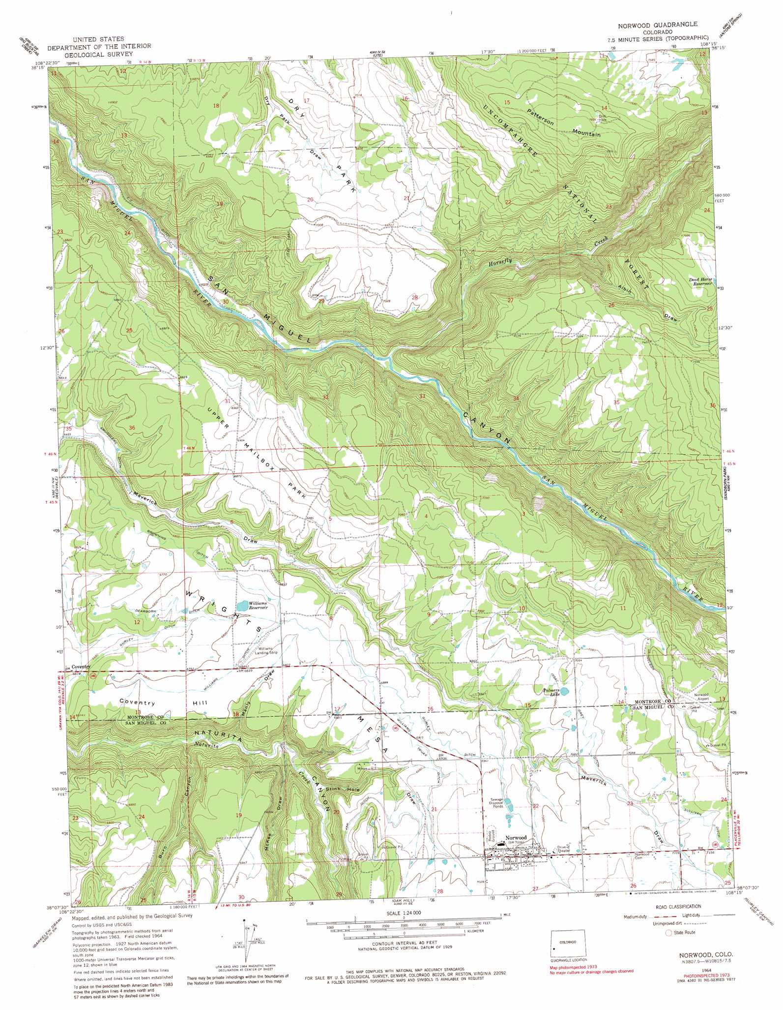
USGS Topo Quad 38108b3 - 1:24,000 scale
| Topo Map Name: | Norwood |
| USGS Topo Quad ID: | 38108b3 |
| Print Size: | ca. 21 1/4" wide x 27" high |
| Southeast Coordinates: | 38.125° N latitude / 108.25° W longitude |
| Map Center Coordinates: | 38.1875° N latitude / 108.3125° W longitude |
| U.S. State: | CO |
| Filename: | o38108b3.jpg |
| Download Map JPG Image: | Norwood topo map 1:24,000 scale |
| Map Type: | Topographic |
| Topo Series: | 7.5´ |
| Map Scale: | 1:24,000 |
| Source of Map Images: | United States Geological Survey (USGS) |
| Alternate Map Versions: |
Norwood CO 1964, updated 1968 Download PDF Buy paper map Norwood CO 1964, updated 1968 Download PDF Buy paper map Norwood CO 1964, updated 1983 Download PDF Buy paper map Norwood CO 2011 Download PDF Buy paper map Norwood CO 2013 Download PDF Buy paper map Norwood CO 2016 Download PDF Buy paper map |
| FStopo: | US Forest Service topo Norwood is available: Download FStopo PDF Download FStopo TIF |
1:24,000 Topo Quads surrounding Norwood
Windy Point |
Starvation Point |
Moore Mesa |
Davis Point |
Dry Creek Basin |
Nucla |
Big Bucktail Creek |
Ute |
Antone Spring |
Pryor Creek |
Naturita |
Redvale |
Norwood |
Sanborn Park |
Hotchkiss Reservoir |
Basin |
Barkelew Draw |
Oak Hill |
Gurley Canyon |
Placerville |
Mckenna Peak |
North Mountain |
Lone Cone |
Beaver Park |
Little Cone |
> Back to 38108a1 at 1:100,000 scale
> Back to 38108a1 at 1:250,000 scale
> Back to U.S. Topo Maps home
Norwood topo map: Gazetteer
Norwood: Airports
Norwood Airport elevation 2225m 7299′Williams Landing Strip elevation 2086m 6843′
Williams Ranch Airport elevation 2085m 6840′
Norwood: Canals
Browning Ditch elevation 2065m 6774′Dearborn Ditch elevation 2065m 6774′
Issac Grey Ditch elevation 2137m 7011′
Nelson Ditch elevation 2196m 7204′
Smugglers Ditch elevation 1993m 6538′
Sullivan Ditch elevation 2184m 7165′
Williams Ditch elevation 2082m 6830′
Williams Truax Ditch elevation 2103m 6899′
Norwood: Flats
Dry Park elevation 2136m 7007′Upper Mailbox Park elevation 2116m 6942′
Norwood: Mines
Big Mack Mine elevation 2137m 7011′Elder Mine elevation 2099m 6886′
Keck-Reliance Mine elevation 2084m 6837′
Mad Jack Number One Mine elevation 2138m 7014′
Mineral Mine elevation 2148m 7047′
Norwood: Populated Places
Coventry elevation 2035m 6676′Norwood elevation 2137m 7011′
Norwood: Reservoirs
Dead Horse Reservoir elevation 2286m 7500′Palmers Lake elevation 2135m 7004′
Williams Reservoir elevation 2076m 6811′
Norwood: Streams
Horsefly Creek elevation 1870m 6135′Norwood: Summits
Coventry Hill elevation 2037m 6683′Patterson Mountain elevation 2417m 7929′
Wrights Mesa elevation 2146m 7040′
Norwood: Valleys
Albin Draw elevation 1944m 6377′Burn Canyon elevation 1929m 6328′
Logging Camp Draw elevation 2025m 6643′
Manly Draw elevation 1950m 6397′
McKee Draw elevation 1965m 6446′
Stink Hole Draw elevation 1981m 6499′
Norwood digital topo map on disk
Buy this Norwood topo map showing relief, roads, GPS coordinates and other geographical features, as a high-resolution digital map file on DVD: