Antone Spring Topo Map Colorado
To zoom in, hover over the map of Antone Spring
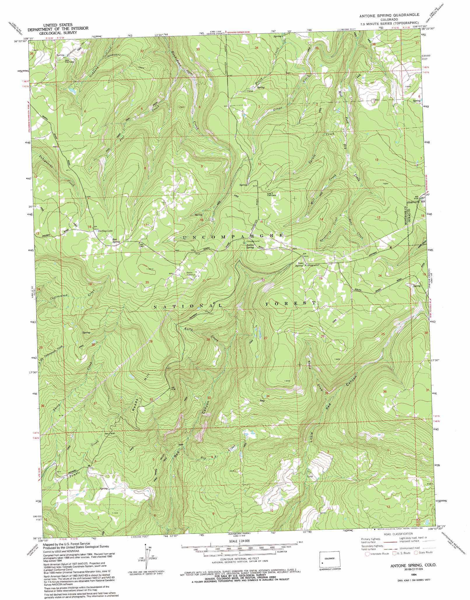
USGS Topo Quad 38108c2 - 1:24,000 scale
| Topo Map Name: | Antone Spring |
| USGS Topo Quad ID: | 38108c2 |
| Print Size: | ca. 21 1/4" wide x 27" high |
| Southeast Coordinates: | 38.25° N latitude / 108.125° W longitude |
| Map Center Coordinates: | 38.3125° N latitude / 108.1875° W longitude |
| U.S. State: | CO |
| Filename: | o38108c2.jpg |
| Download Map JPG Image: | Antone Spring topo map 1:24,000 scale |
| Map Type: | Topographic |
| Topo Series: | 7.5´ |
| Map Scale: | 1:24,000 |
| Source of Map Images: | United States Geological Survey (USGS) |
| Alternate Map Versions: |
Antone Spring CO 1973, updated 1976 Download PDF Buy paper map Antone Spring CO 1973, updated 1980 Download PDF Buy paper map Antone Spring CO 1994, updated 1994 Download PDF Buy paper map Antone Spring CO 2011 Download PDF Buy paper map Antone Spring CO 2013 Download PDF Buy paper map Antone Spring CO 2016 Download PDF Buy paper map |
| FStopo: | US Forest Service topo Antone Spring is available: Download FStopo PDF Download FStopo TIF |
1:24,000 Topo Quads surrounding Antone Spring
Kelso Point |
Cottonwood Basin |
Camel Back |
Hoovers Corner |
Olathe |
Starvation Point |
Moore Mesa |
Davis Point |
Dry Creek Basin |
Montrose West |
Big Bucktail Creek |
Ute |
Antone Spring |
Pryor Creek |
Government Springs |
Redvale |
Norwood |
Sanborn Park |
Hotchkiss Reservoir |
Horsefly Peak |
Barkelew Draw |
Oak Hill |
Gurley Canyon |
Placerville |
Sams |
> Back to 38108a1 at 1:100,000 scale
> Back to 38108a1 at 1:250,000 scale
> Back to U.S. Topo Maps home
Antone Spring topo map: Gazetteer
Antone Spring: Airports
Raspberry Heliport elevation 2703m 8868′Antone Spring: Forests
Uncompahgre National Forest elevation 2855m 9366′Antone Spring: Lakes
Darling Lake elevation 3011m 9878′Antone Spring: Mines
Too High Mine elevation 2782m 9127′Uranium Girl Mine elevation 2999m 9839′
Antone Spring: Springs
Antone Spring elevation 2932m 9619′Box Spring elevation 3016m 9895′
Iron Spring elevation 2920m 9580′
Spruce Spring elevation 2874m 9429′
Antone Spring: Streams
Bear Creek elevation 2730m 8956′Big A Creek elevation 2299m 7542′
Kelly Creek elevation 2544m 8346′
Mill Creek elevation 2660m 8727′
Pool Creek elevation 2541m 8336′
Raspberry Creek elevation 2730m 8956′
Spruce Creek elevation 2620m 8595′
Antone Spring: Summits
Reade Hill elevation 2965m 9727′Antone Spring: Trails
Hanks Valley Trail elevation 2429m 7969′Pool Creek Trail elevation 2787m 9143′
Pool Creek Trail elevation 2709m 8887′
Antone Spring: Valleys
Coal Canyon elevation 2940m 9645′State Draw elevation 2543m 8343′
Antone Spring digital topo map on disk
Buy this Antone Spring topo map showing relief, roads, GPS coordinates and other geographical features, as a high-resolution digital map file on DVD: