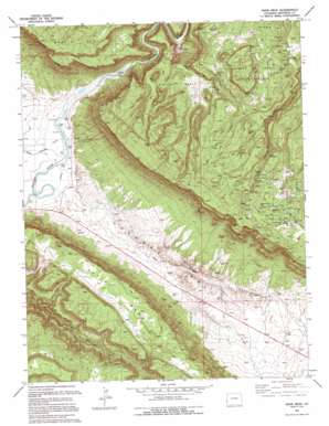
Davis Mesa Topo Map Colorado
To zoom in, hover over the map of Davis Mesa
USGS Topo Quad 38108c7 - 1:24,000 scale
| Topo Map Name: | Davis Mesa |
| USGS Topo Quad ID: | 38108c7 |
| Print Size: | ca. 21 1/4" wide x 27" high |
| Southeast Coordinates: | 38.25° N latitude / 108.75° W longitude |
| Map Center Coordinates: | 38.3125° N latitude / 108.8125° W longitude |
| U.S. State: | CO |
| Filename: | o38108c7.jpg |
| Download Map JPG Image: | Davis Mesa topo map 1:24,000 scale |
| Map Type: | Topographic |
| Topo Series: | 7.5´ |
| Map Scale: | 1:24,000 |
| Source of Map Images: | United States Geological Survey (USGS) |
| Alternate Map Versions: |
Davis Mesa CO 1949 Download PDF Buy paper map Davis Mesa CO 1960, updated 1961 Download PDF Buy paper map Davis Mesa CO 1994, updated 1994 Download PDF Buy paper map Davis Mesa CO 2011 Download PDF Buy paper map Davis Mesa CO 2013 Download PDF Buy paper map Davis Mesa CO 2016 Download PDF Buy paper map |
1:24,000 Topo Quads surrounding Davis Mesa
> Back to 38108a1 at 1:100,000 scale
> Back to 38108a1 at 1:250,000 scale
> Back to U.S. Topo Maps home
Davis Mesa topo map: Gazetteer
Davis Mesa: Basins
Paradox Valley elevation 1507m 4944′Saucer Basin elevation 1750m 5741′
Davis Mesa: Mines
Badger Dump Mine elevation 2066m 6778′Ball Point Mine elevation 1854m 6082′
Better Be Mine elevation 1669m 5475′
Black Diana Mine elevation 1990m 6528′
Bobcat Mine elevation 1994m 6541′
Buck Shot Mine elevation 1810m 5938′
Buckeye Mine elevation 1996m 6548′
Burnette Number Five Mine elevation 1734m 5688′
Camp Marvel Carnotite Mine elevation 1996m 6548′
Carleton Mine elevation 2024m 6640′
Carmack Potash Mine elevation 1516m 4973′
CFC Mine elevation 1941m 6368′
Club Number 7 Mine elevation 1792m 5879′
Coloradium Mine elevation 1974m 6476′
Columbia Mine elevation 2024m 6640′
Cripple Creek Dump Mine elevation 1979m 6492′
Cripple Creek Mine elevation 1977m 6486′
Donald L Dump Mine elevation 1974m 6476′
Dorothy Mine elevation 1934m 6345′
Dusty Mine elevation 1985m 6512′
Dynamite Mine elevation 1964m 6443′
Fawn Springs Number Ten Mine elevation 1626m 5334′
Firebird Mine elevation 1930m 6332′
Florence Nellie Mine elevation 2015m 6610′
Fort Number One Mine elevation 2024m 6640′
Grace Mine elevation 1961m 6433′
Groundhog Mine elevation 1952m 6404′
Groundhog Mine elevation 1953m 6407′
Half Shot Mine elevation 1708m 5603′
Happy Mine elevation 1970m 6463′
Helen C Mine elevation 1938m 6358′
Henry Clay Dumps Mine elevation 2024m 6640′
Henry Clay Mine elevation 2024m 6640′
Henry Z Mine elevation 1945m 6381′
Hidden Basin Mine elevation 1944m 6377′
Honeymoon Dumps Mine elevation 2030m 6660′
Honeymoon Mine elevation 2040m 6692′
Kern Mine elevation 1996m 6548′
La Salle Mine elevation 1833m 6013′
Lucky Boulder Mine elevation 1732m 5682′
Maggie C Dump Mine elevation 1982m 6502′
Mill Number 2 Mine elevation 1781m 5843′
Mill Number 4 Mine elevation 1810m 5938′
Monogram Mine elevation 2004m 6574′
Monster Mine elevation 1736m 5695′
Moon Beem Mine elevation 1996m 6548′
New Long Park Mine elevation 1996m 6548′
North Star Mine elevation 1996m 6548′
Pearl Walker Mine elevation 1734m 5688′
Peggie Group Mine elevation 1734m 5688′
Phonograph Mine elevation 2018m 6620′
Pie Face Mine elevation 2024m 6640′
Ram Mine elevation 1780m 5839′
Rambler Mine elevation 1708m 5603′
Rambler Point Mine elevation 1780m 5839′
Republican Dump Mine elevation 2020m 6627′
Republican Mine elevation 2014m 6607′
San Miguel Mine elevation 1752m 5748′
Saucer Basin Mine elevation 1831m 6007′
Sharkey Mine elevation 2009m 6591′
Silver Dollar Mine elevation 1996m 6548′
Sunshine Mine elevation 1971m 6466′
Surprise Number One Mine elevation 1759m 5770′
TM Mine elevation 1710m 5610′
TNT Number 1 Mine elevation 1951m 6400′
TNT Number 2 Mine elevation 1952m 6404′
TNT Number 3 Mine elevation 1952m 6404′
Tramp Dumps Mine elevation 1852m 6076′
Tramp Mine elevation 1996m 6548′
Tramp Number 2 Mine elevation 1834m 6017′
Tripod Mine elevation 2032m 6666′
Vacation Mine elevation 1588m 5209′
Valentine Mine elevation 1700m 5577′
Vanadate Mine elevation 2022m 6633′
Washburn Mine elevation 1971m 6466′
West Lode elevation 1724m 5656′
Davis Mesa: Springs
Stone Spring elevation 1562m 5124′Davis Mesa: Streams
East Paradox Creek elevation 1504m 4934′Gregory Creek elevation 1739m 5705′
West Paradox Creek elevation 1503m 4931′
Davis Mesa: Summits
Davis Mesa elevation 1974m 6476′Martin Mesa elevation 2137m 7011′
Skein Mesa elevation 2172m 7125′
Davis Mesa: Wells
Prospector Well elevation 1653m 5423′Davis Mesa digital topo map on disk
Buy this Davis Mesa topo map showing relief, roads, GPS coordinates and other geographical features, as a high-resolution digital map file on DVD:


