Calamity Mesa Topo Map Colorado
To zoom in, hover over the map of Calamity Mesa
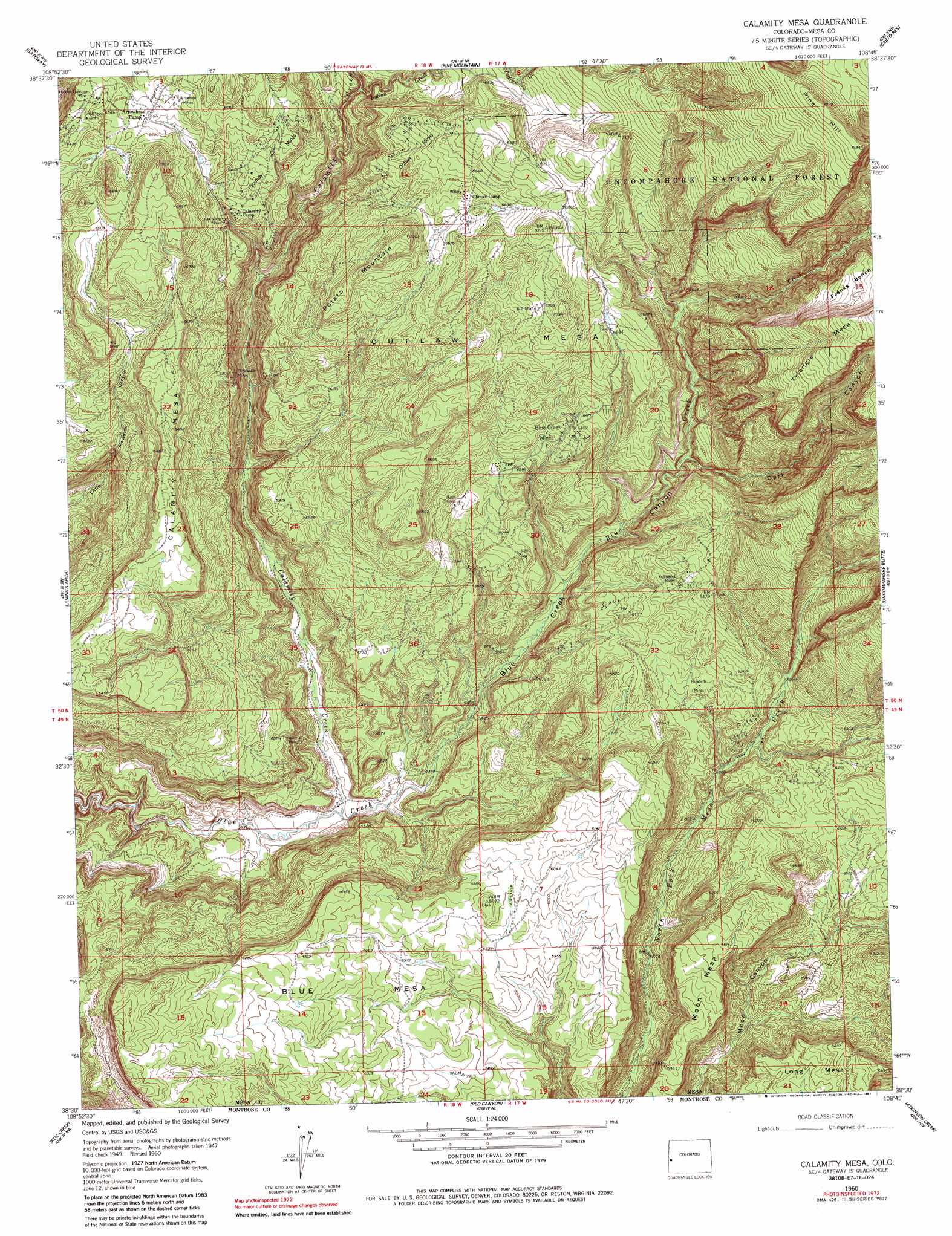
USGS Topo Quad 38108e7 - 1:24,000 scale
| Topo Map Name: | Calamity Mesa |
| USGS Topo Quad ID: | 38108e7 |
| Print Size: | ca. 21 1/4" wide x 27" high |
| Southeast Coordinates: | 38.5° N latitude / 108.75° W longitude |
| Map Center Coordinates: | 38.5625° N latitude / 108.8125° W longitude |
| U.S. State: | CO |
| Filename: | o38108e7.jpg |
| Download Map JPG Image: | Calamity Mesa topo map 1:24,000 scale |
| Map Type: | Topographic |
| Topo Series: | 7.5´ |
| Map Scale: | 1:24,000 |
| Source of Map Images: | United States Geological Survey (USGS) |
| Alternate Map Versions: |
Calamity Mesa CO 1949, updated 1955 Download PDF Buy paper map Calamity Mesa CO 1949, updated 1955 Download PDF Buy paper map Calamity Mesa CO 1950 Download PDF Buy paper map Calamity Mesa CO 1960, updated 1961 Download PDF Buy paper map Calamity Mesa CO 1960, updated 1961 Download PDF Buy paper map Calamity Mesa CO 1960, updated 1983 Download PDF Buy paper map Calamity Mesa CO 1960, updated 1987 Download PDF Buy paper map Calamity Mesa CO 2011 Download PDF Buy paper map Calamity Mesa CO 2013 Download PDF Buy paper map Calamity Mesa CO 2016 Download PDF Buy paper map |
| FStopo: | US Forest Service topo Calamity Mesa is available: Download FStopo PDF Download FStopo TIF |
1:24,000 Topo Quads surrounding Calamity Mesa
Steamboat Mesa |
Two V Basin |
Fish Creek |
Snyder Flats |
Jacks Canyon |
Dolores Point North |
Gateway |
Pine Mountain |
Casto Reservoir |
Keith Creek |
Dolores Point South |
Juanita Arch |
Calamity Mesa |
Uncompahgre Butte |
Snipe Mountain |
Buckeye Reservoir |
Roc Creek |
Red Canyon |
Atkinson Creek |
Windy Point |
Wray Mesa |
Paradox |
Davis Mesa |
Uravan |
Nucla |
> Back to 38108e1 at 1:100,000 scale
> Back to 38108a1 at 1:250,000 scale
> Back to U.S. Topo Maps home
Calamity Mesa topo map: Gazetteer
Calamity Mesa: Mines
Arrowhead Mine elevation 2094m 6870′Arrowhead Mines elevation 2013m 6604′
Blue Creek Mines elevation 1947m 6387′
Calamity Mine elevation 1926m 6318′
Calamity Mines elevation 1990m 6528′
Cliffdweller Mines elevation 1821m 5974′
Elizabeth Mines elevation 1868m 6128′
G-2 Shaft elevation 2097m 6879′
Hidden Treasure Mine elevation 1988m 6522′
New Verde Mines elevation 1943m 6374′
Outlaw Mines elevation 2067m 6781′
Outlaw Twenty-three Mine elevation 2068m 6784′
Peach Mines elevation 1853m 6079′
Powder Horn Incline Mine elevation 2014m 6607′
Raven Mine elevation 1892m 6207′
Ronnie Mine elevation 2049m 6722′
Salute Mine elevation 1970m 6463′
Scott Mine elevation 1952m 6404′
Small Spot Mine elevation 1982m 6502′
Snowshoe Mine elevation 2046m 6712′
Spring Mine elevation 2046m 6712′
Stormy Treasure Mine elevation 1651m 5416′
Supply Eleven Mine elevation 1745m 5725′
Teepee Pole Mine elevation 1766m 5793′
Trojan Mine elevation 1905m 6250′
Yellowbird Mines elevation 1929m 6328′
Calamity Mesa: Streams
Calamity Creek elevation 1580m 5183′Indian Creek elevation 1970m 6463′
Calamity Mesa: Summits
Calamity Mesa elevation 2035m 6676′Long Mesa elevation 1912m 6272′
Moon Mesa elevation 1934m 6345′
Outlaw Mesa elevation 2189m 7181′
Pine Hill elevation 2494m 8182′
Potato Mountain elevation 2133m 6998′
Calamity Mesa: Valleys
Dark Canyon elevation 1814m 5951′Calamity Mesa digital topo map on disk
Buy this Calamity Mesa topo map showing relief, roads, GPS coordinates and other geographical features, as a high-resolution digital map file on DVD: