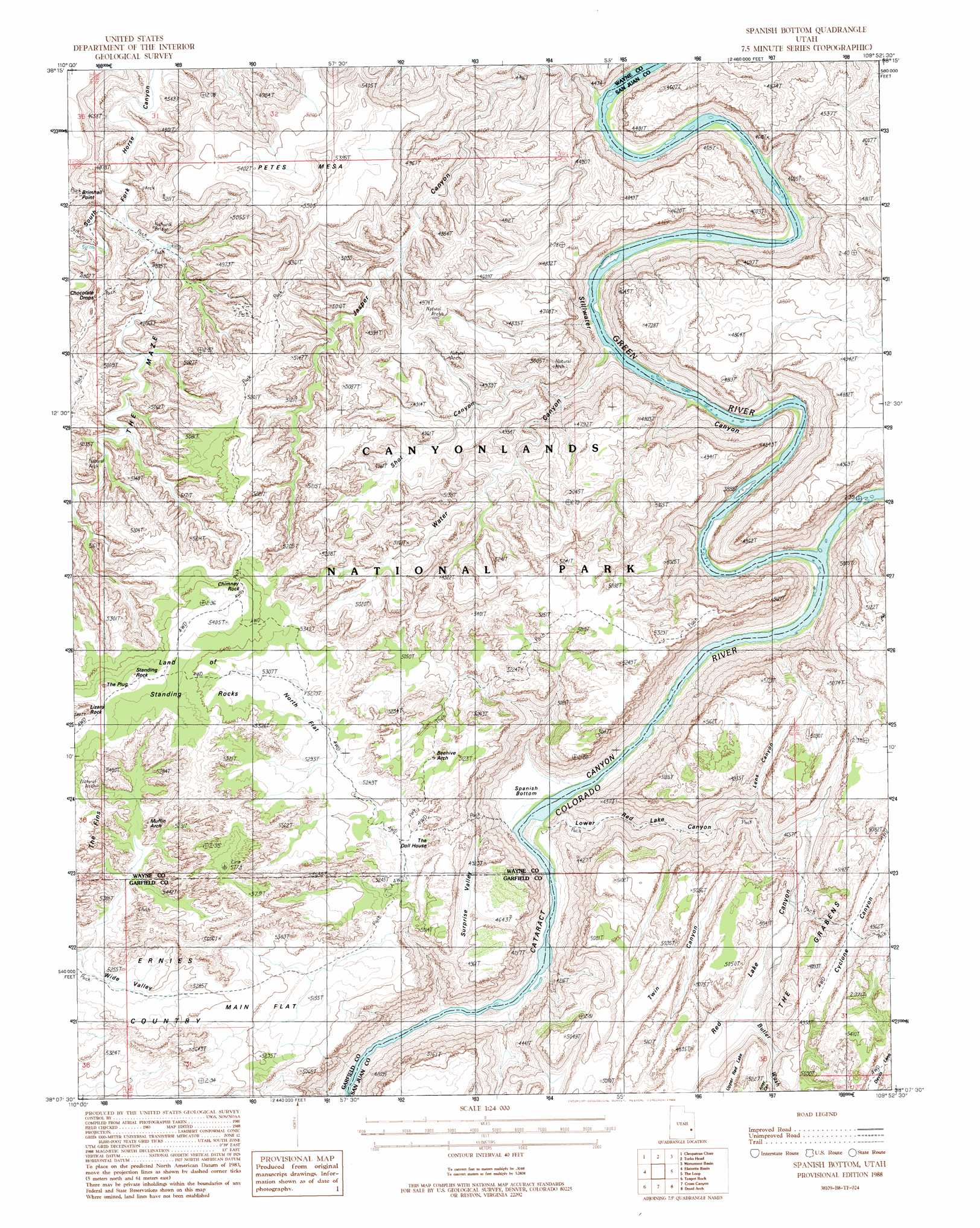
Spanish Bottom Topo Map Utah
To zoom in, hover over the map of Spanish Bottom
USGS Topo Quad 38109b8 - 1:24,000 scale
| Topo Map Name: | Spanish Bottom |
| USGS Topo Quad ID: | 38109b8 |
| Print Size: | ca. 21 1/4" wide x 27" high |
| Southeast Coordinates: | 38.125° N latitude / 109.875° W longitude |
| Map Center Coordinates: | 38.1875° N latitude / 109.9375° W longitude |
| U.S. State: | UT |
| Filename: | o38109b8.jpg |
| Download Map JPG Image: | Spanish Bottom topo map 1:24,000 scale |
| Map Type: | Topographic |
| Topo Series: | 7.5´ |
| Map Scale: | 1:24,000 |
| Source of Map Images: | United States Geological Survey (USGS) |
| Alternate Map Versions: |
Carlisle 3 NW UT 1953, updated 1954 Download PDF Buy paper map Spanish Bottom UT 1988, updated 1988 Download PDF Buy paper map Spanish Bottom UT 1996, updated 2002 Download PDF Buy paper map Spanish Bottom UT 2010 Download PDF Buy paper map Spanish Bottom UT 2014 Download PDF Buy paper map |
1:24,000 Topo Quads surrounding Spanish Bottom
Sugarloaf Butte |
Horsethief Canyon |
Upheaval Dome |
Musselman Arch |
Shafer Basin |
Head Spur |
Cleopatras Chair |
Turks Head |
Monument Basin |
Lockhart Basin |
Gordon Flats |
Elaterite Basin |
Spanish Bottom |
The Loop |
North Six-Shooter Peak |
Clearwater Canyon |
Teapot Rock |
Cross Canyon |
Druid Arch |
South Six-Shooter Peak |
Bowdie Canyon West |
Bowdie Canyon East |
Fable Valley |
House Park Butte |
Cathedral Butte |
> Back to 38109a1 at 1:100,000 scale
> Back to 38108a1 at 1:250,000 scale
> Back to U.S. Topo Maps home
Spanish Bottom topo map: Gazetteer
Spanish Bottom: Arches
Beehive Arch elevation 1574m 5164′Muffin Arch elevation 1612m 5288′
Thieves Cache Arch elevation 1450m 4757′
Spanish Bottom: Areas
Land of Standing Rocks elevation 1669m 5475′Land of Standing Rocks elevation 1636m 5367′
Land of Standing Rocks elevation 1666m 5465′
Sin-av-to-weap elevation 1181m 3874′
The Confluence elevation 1181m 3874′
The Doll House elevation 1574m 5164′
The Doll House elevation 1562m 5124′
Spanish Bottom: Bends
Spanish Bottom elevation 1191m 3907′Spanish Bottom: Cliffs
Cave Cliff elevation 1299m 4261′Spanish Bottom: Flats
Main Flat elevation 1590m 5216′North Flat elevation 1621m 5318′
Red Lake Canyon elevation 1356m 4448′
Spanish Bottom: Parks
Canyonlands National Park elevation 1667m 5469′Spanish Bottom: Pillars
Chimney Rock elevation 1658m 5439′Chocolate Drops elevation 1547m 5075′
Standing Rock elevation 1681m 5515′
The Plug elevation 1601m 5252′
Spanish Bottom: Rapids
Brown Betty Rapids elevation 1196m 3923′Spanish Bottom: Streams
Butler Wash elevation 1181m 3874′Green River elevation 1181m 3874′
Spanish Bottom: Summits
Petes Mesa elevation 1671m 5482′Spanish Bottom: Valleys
Aztec Canyon elevation 1457m 4780′Aztec Canyon elevation 1462m 4796′
East Fork Twin Canyon elevation 1439m 4721′
Jasper Canyon elevation 1192m 3910′
Jasper Canyon elevation 1192m 3910′
Lens Canyon elevation 1181m 3874′
Lower Red Lake Canyon elevation 1181m 3874′
Lower Red Lake Canyon elevation 1183m 3881′
Meander Canyon elevation 1181m 3874′
Shot Canyon elevation 1231m 4038′
Shot Canyon elevation 1264m 4146′
Stillwater Canyon elevation 1181m 3874′
Suprise Valley elevation 1404m 4606′
Twin Canyon elevation 1506m 4940′
Water Canyon elevation 1181m 3874′
Water Canyon elevation 1256m 4120′
West Fork Twin Canyon elevation 1439m 4721′
Spanish Bottom digital topo map on disk
Buy this Spanish Bottom topo map showing relief, roads, GPS coordinates and other geographical features, as a high-resolution digital map file on DVD: