La Sal East Topo Map Utah
To zoom in, hover over the map of La Sal East
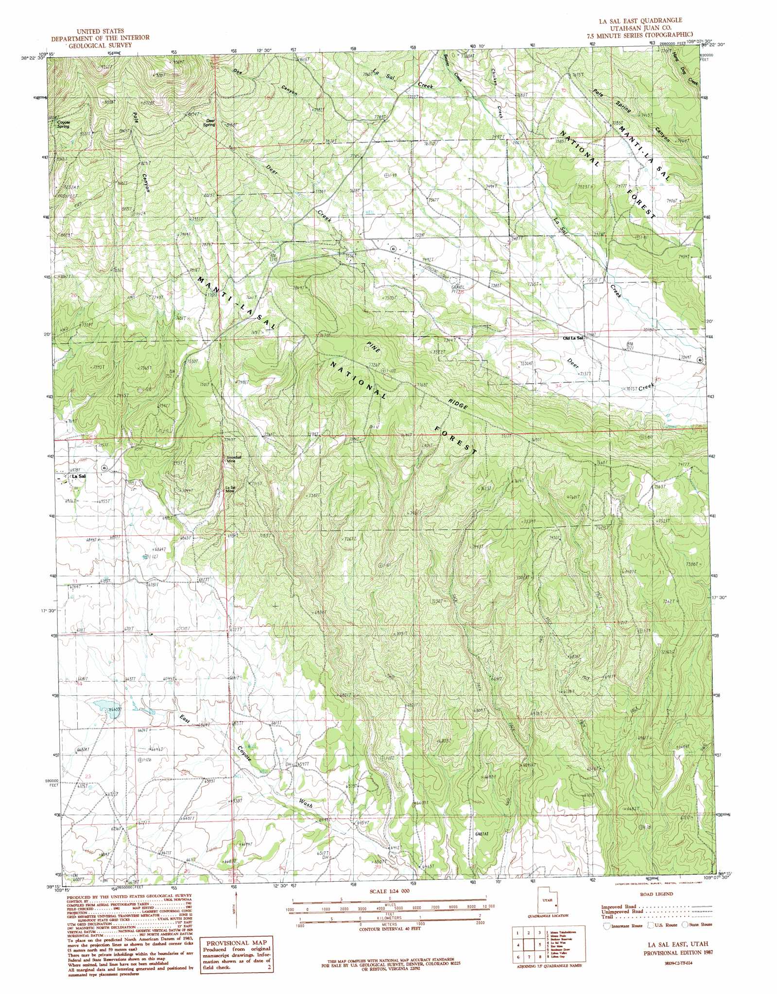
USGS Topo Quad 38109c2 - 1:24,000 scale
| Topo Map Name: | La Sal East |
| USGS Topo Quad ID: | 38109c2 |
| Print Size: | ca. 21 1/4" wide x 27" high |
| Southeast Coordinates: | 38.25° N latitude / 109.125° W longitude |
| Map Center Coordinates: | 38.3125° N latitude / 109.1875° W longitude |
| U.S. State: | UT |
| Filename: | o38109c2.jpg |
| Download Map JPG Image: | La Sal East topo map 1:24,000 scale |
| Map Type: | Topographic |
| Topo Series: | 7.5´ |
| Map Scale: | 1:24,000 |
| Source of Map Images: | United States Geological Survey (USGS) |
| Alternate Map Versions: |
Mt Peale 1 SW UT 1954, updated 1955 Download PDF Buy paper map La Sal East UT 1987, updated 1987 Download PDF Buy paper map La Sal East UT 1987, updated 1987 Download PDF Buy paper map La Sal East UT 2001, updated 2004 Download PDF Buy paper map La Sal East UT 2011 Download PDF Buy paper map La Sal East UT 2014 Download PDF Buy paper map |
| FStopo: | US Forest Service topo La Sal East is available: Download FStopo PDF Download FStopo TIF |
1:24,000 Topo Quads surrounding La Sal East
Rill Creek |
Warner Lake |
Mount Waas |
Dolores Point South |
Juanita Arch |
Kane Springs |
Mount Tukuhnikivatz |
Mount Peale |
Buckeye Reservoir |
Roc Creek |
La Sal Junction |
La Sal West |
La Sal East |
Wray Mesa |
Paradox |
Hatch Rock |
Sandstone Draw |
Lisbon Valley |
Lisbon Gap |
Anderson Mesa |
Photograph Gap |
Church Rock |
Sop Canyon |
Summit Point |
Horse Range Mesa |
> Back to 38109a1 at 1:100,000 scale
> Back to 38108a1 at 1:250,000 scale
> Back to U.S. Topo Maps home
La Sal East topo map: Gazetteer
La Sal East: Dams
Wilcox Dam elevation 2025m 6643′La Sal East: Mines
La Sal Mine elevation 2143m 7030′Pine Ridge Mine elevation 2287m 7503′
Snow Ball Mine elevation 2132m 6994′
Snowball Mine elevation 2185m 7168′
La Sal East: Populated Places
La Sal elevation 2127m 6978′Old La Sal elevation 2184m 7165′
La Sal East: Reservoirs
Wilcox Reservoir elevation 2025m 6643′La Sal East: Ridges
Pine Ridge elevation 2370m 7775′La Sal East: Springs
Coyote Spring elevation 2588m 8490′Deer Spring elevation 2513m 8244′
La Sal East: Streams
Beaver Creek elevation 2306m 7565′Chicken Creek elevation 2289m 7509′
Deer Creek elevation 2135m 7004′
La Sal East: Valleys
Doe Canyon elevation 2277m 7470′Pole Canyon elevation 2171m 7122′
La Sal East digital topo map on disk
Buy this La Sal East topo map showing relief, roads, GPS coordinates and other geographical features, as a high-resolution digital map file on DVD: