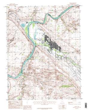
Moab Topo Map Utah
To zoom in, hover over the map of Moab
USGS Topo Quad 38109e5 - 1:24,000 scale
| Topo Map Name: | Moab |
| USGS Topo Quad ID: | 38109e5 |
| Print Size: | ca. 21 1/4" wide x 27" high |
| Southeast Coordinates: | 38.5° N latitude / 109.5° W longitude |
| Map Center Coordinates: | 38.5625° N latitude / 109.5625° W longitude |
| U.S. State: | UT |
| Filename: | o38109e5.jpg |
| Download Map JPG Image: | Moab topo map 1:24,000 scale |
| Map Type: | Topographic |
| Topo Series: | 7.5´ |
| Map Scale: | 1:24,000 |
| Source of Map Images: | United States Geological Survey (USGS) |
| Alternate Map Versions: |
Moab 4 SE UT 1959, updated 1961 Download PDF Buy paper map Moab UT 1985, updated 1986 Download PDF Buy paper map Moab UT 1985, updated 1986 Download PDF Buy paper map Moab UT 1985, updated 1986 Download PDF Buy paper map Moab UT 2011 Download PDF Buy paper map Moab UT 2014 Download PDF Buy paper map |
1:24,000 Topo Quads surrounding Moab
> Back to 38109e1 at 1:100,000 scale
> Back to 38108a1 at 1:250,000 scale
> Back to U.S. Topo Maps home
Moab topo map: Gazetteer
Moab: Airports
Allen Memorial Hospital Heliport elevation 1211m 3973′Sunbird Airport elevation 1405m 4609′
Moab: Arches
Corona Arch elevation 1336m 4383′Funnel Arch elevation 1345m 4412′
Hall Bridge elevation 1378m 4520′
Hunter Arch elevation 1376m 4514′
Huntress Arch elevation 1303m 4274′
Magic Theater Arch elevation 1347m 4419′
Morning Glory Arch elevation 1315m 4314′
Pritchett Natural Bridge elevation 1474m 4835′
Updraft Arch elevation 1397m 4583′
Window Arch elevation 1436m 4711′
Moab: Bends
Kings Bottom elevation 1207m 3959′Moab Valley elevation 1214m 3982′
Williams Bottom elevation 1206m 3956′
Moab: Dams
Atlas Mineral Tailings Pond Dam elevation 1231m 4038′Moab: Flats
Spanish Valley elevation 1320m 4330′Moab: Parks
Lions Park elevation 1212m 3976′Moab KOA elevation 1380m 4527′
Slickrock Country Camp elevation 1210m 3969′
Moab: Populated Places
Moab elevation 1227m 4025′Moab: Post Offices
Moab Post Office elevation 1231m 4038′Moab: Reservoirs
Jackson Reservoir elevation 1290m 4232′Moab: Springs
King Bottom Spring elevation 1216m 3989′Matrimony Spring elevation 1219m 3999′
Moab: Streams
Kane Springs Creek elevation 1205m 3953′Mill Creek elevation 1210m 3969′
North Fork Mill Creek elevation 1304m 4278′
Pack Creek elevation 1221m 4005′
Moab: Summits
Poison Spider Mesa elevation 1430m 4691′The Portal elevation 1453m 4767′
Three Penguins elevation 1361m 4465′
Moab: Trails
Moab Slickrock Trail elevation 1337m 4386′Moab: Valleys
Courthouse Wash elevation 1207m 3959′Hunters Canyon elevation 1240m 4068′
Kane Springs Canyon elevation 1206m 3956′
Moab Canyon elevation 1207m 3959′
Negro Bill Canyon elevation 1225m 4019′
Pritchett Canyon elevation 1205m 3953′
Moab digital topo map on disk
Buy this Moab topo map showing relief, roads, GPS coordinates and other geographical features, as a high-resolution digital map file on DVD:


