Fisher Valley Topo Map Utah
To zoom in, hover over the map of Fisher Valley
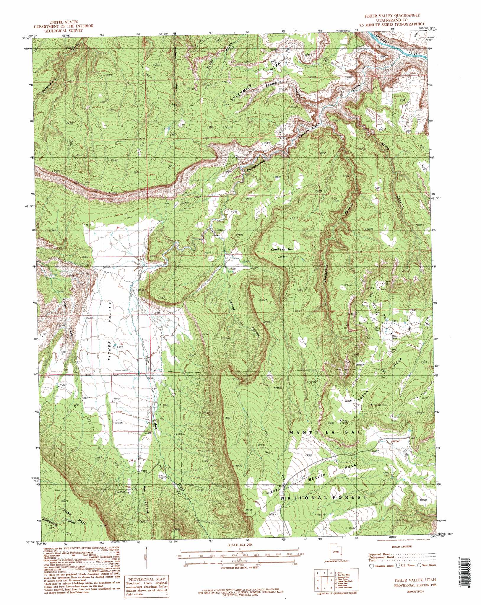
USGS Topo Quad 38109f2 - 1:24,000 scale
| Topo Map Name: | Fisher Valley |
| USGS Topo Quad ID: | 38109f2 |
| Print Size: | ca. 21 1/4" wide x 27" high |
| Southeast Coordinates: | 38.625° N latitude / 109.125° W longitude |
| Map Center Coordinates: | 38.6875° N latitude / 109.1875° W longitude |
| U.S. State: | UT |
| Filename: | o38109f2.jpg |
| Download Map JPG Image: | Fisher Valley topo map 1:24,000 scale |
| Map Type: | Topographic |
| Topo Series: | 7.5´ |
| Map Scale: | 1:24,000 |
| Source of Map Images: | United States Geological Survey (USGS) |
| Alternate Map Versions: |
Mt. Waas 4 NW UT 1954, updated 1955 Download PDF Buy paper map Fisher Valley UT 1985, updated 1986 Download PDF Buy paper map Fisher Valley UT 2001, updated 2004 Download PDF Buy paper map Fisher Valley UT 2011 Download PDF Buy paper map Fisher Valley UT 2014 Download PDF Buy paper map |
| FStopo: | US Forest Service topo Fisher Valley is available: Download FStopo PDF Download FStopo TIF |
1:24,000 Topo Quads surrounding Fisher Valley
White House |
Cisco |
Big Triangle |
Marble Canyon |
Bieser Creek |
Cisco Sw |
Dewey |
Blue Chief Mesa |
Steamboat Mesa |
Two V Basin |
Big Bend |
Fisher Towers |
Fisher Valley |
Dolores Point North |
Gateway |
Rill Creek |
Warner Lake |
Mount Waas |
Dolores Point South |
Juanita Arch |
Kane Springs |
Mount Tukuhnikivatz |
Mount Peale |
Buckeye Reservoir |
Roc Creek |
> Back to 38109e1 at 1:100,000 scale
> Back to 38108a1 at 1:250,000 scale
> Back to U.S. Topo Maps home
Fisher Valley topo map: Gazetteer
Fisher Valley: Streams
Fisher Creek elevation 1308m 4291′Fisher Valley: Summits
Cowhead Hill elevation 1989m 6525′North Beaver Mesa elevation 2529m 8297′
Polar Mesa elevation 2452m 8044′
Sevenmile Mesa elevation 2158m 7080′
Fisher Valley: Valleys
Bull Canyon elevation 1869m 6131′Burro Canyon elevation 1384m 4540′
Cottonwood Canyon elevation 1307m 4288′
Fisher Valley elevation 1695m 5561′
Hideout Canyon elevation 1636m 5367′
Sevenmile Canyon elevation 1399m 4589′
Thompson Canyon elevation 1417m 4648′
Fisher Valley digital topo map on disk
Buy this Fisher Valley topo map showing relief, roads, GPS coordinates and other geographical features, as a high-resolution digital map file on DVD: