Bull Mountain Topo Map Utah
To zoom in, hover over the map of Bull Mountain
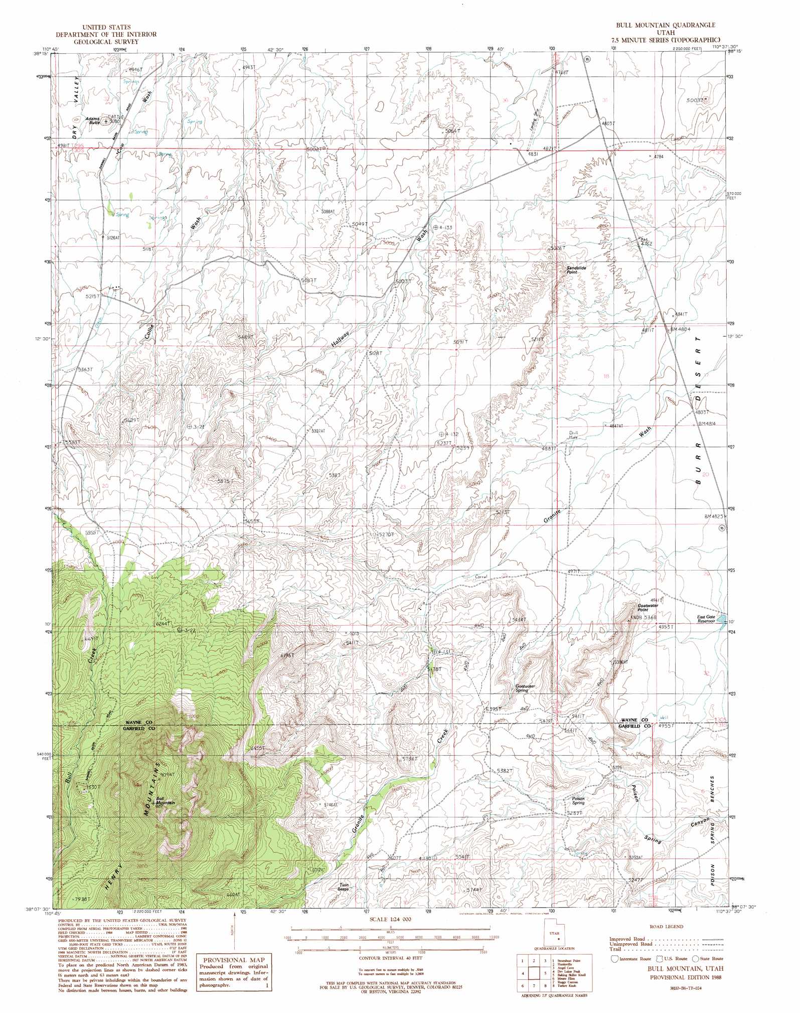
USGS Topo Quad 38110b6 - 1:24,000 scale
| Topo Map Name: | Bull Mountain |
| USGS Topo Quad ID: | 38110b6 |
| Print Size: | ca. 21 1/4" wide x 27" high |
| Southeast Coordinates: | 38.125° N latitude / 110.625° W longitude |
| Map Center Coordinates: | 38.1875° N latitude / 110.6875° W longitude |
| U.S. State: | UT |
| Filename: | o38110b6.jpg |
| Download Map JPG Image: | Bull Mountain topo map 1:24,000 scale |
| Map Type: | Topographic |
| Topo Series: | 7.5´ |
| Map Scale: | 1:24,000 |
| Source of Map Images: | United States Geological Survey (USGS) |
| Alternate Map Versions: |
Mt. Ellen 4 NW UT 1952, updated 1954 Download PDF Buy paper map Bull Mountain UT 1988, updated 1988 Download PDF Buy paper map Bull Mountain UT 2011 Download PDF Buy paper map Bull Mountain UT 2014 Download PDF Buy paper map |
1:24,000 Topo Quads surrounding Bull Mountain
Factory Butte |
Skyline Rim |
The Notch |
Point Of Rocks West |
Point Of Rocks East |
Town Point |
Steamboat Point |
Hanksville |
Angel Cove |
Angel Point |
Stevens Mesa |
Dry Lakes Peak |
Bull Mountain |
Baking Skillet Knoll |
Burr Point |
Steele Butte |
Mount Ellen |
Raggy Canyon |
Turkey Knob |
Stair Canyon |
Cave Flat |
Mount Pennell |
Cass Creek Peak |
Black Table |
Hite North |
> Back to 38110a1 at 1:100,000 scale
> Back to 38110a1 at 1:250,000 scale
> Back to U.S. Topo Maps home
Bull Mountain topo map: Gazetteer
Bull Mountain: Airports
Energy Airport elevation 1463m 4799′Bull Mountain: Cliffs
Goatwater Point elevation 1564m 5131′Sandslide Point elevation 1533m 5029′
Bull Mountain: Reservoirs
East Gate Reservoir elevation 1479m 4852′Bull Mountain: Springs
Goatwater Spring elevation 1571m 5154′Poison Spring elevation 1597m 5239′
Twin Seeps elevation 1726m 5662′
Bull Mountain: Streams
Granite Creek elevation 1547m 5075′Bull Mountain: Summits
Adams Butte elevation 1548m 5078′Blue Knoll elevation 1585m 5200′
Bull Mountain elevation 2790m 9153′
Bull Mountain digital topo map on disk
Buy this Bull Mountain topo map showing relief, roads, GPS coordinates and other geographical features, as a high-resolution digital map file on DVD: