Golden Throne Topo Map Utah
To zoom in, hover over the map of Golden Throne
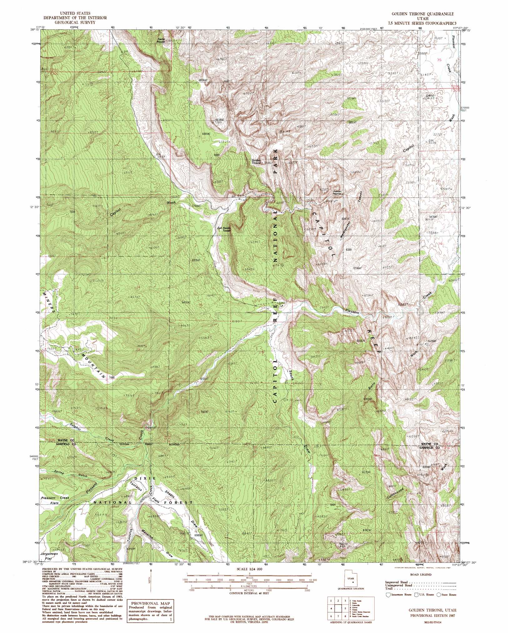
USGS Topo Quad 38111b2 - 1:24,000 scale
| Topo Map Name: | Golden Throne |
| USGS Topo Quad ID: | 38111b2 |
| Print Size: | ca. 21 1/4" wide x 27" high |
| Southeast Coordinates: | 38.125° N latitude / 111.125° W longitude |
| Map Center Coordinates: | 38.1875° N latitude / 111.1875° W longitude |
| U.S. State: | UT |
| Filename: | o38111b2.jpg |
| Download Map JPG Image: | Golden Throne topo map 1:24,000 scale |
| Map Type: | Topographic |
| Topo Series: | 7.5´ |
| Map Scale: | 1:24,000 |
| Source of Map Images: | United States Geological Survey (USGS) |
| Alternate Map Versions: |
Notom 4 NW UT 1952, updated 1954 Download PDF Buy paper map Golden Throne UT 1987, updated 1987 Download PDF Buy paper map Golden Throne UT 2002, updated 2005 Download PDF Buy paper map Golden Throne UT 2011 Download PDF Buy paper map Golden Throne UT 2014 Download PDF Buy paper map |
| FStopo: | US Forest Service topo Golden Throne is available: Download FStopo PDF Download FStopo TIF |
1:24,000 Topo Quads surrounding Golden Throne
Flat Top |
Cathedral Mountain |
Fruita Nw |
Caine Springs |
Factory Butte |
Torrey |
Twin Rocks |
Fruita |
Caineville |
Town Point |
Blind Lake |
Grover |
Golden Throne |
Notom |
Stevens Mesa |
Deer Creek Lake |
Lower Bowns Reservoir |
Bear Canyon |
Sandy Creek Benches |
Steele Butte |
Boulder Town |
Steep Creek Bench |
Lamp Stand |
Bitter Creek Divide |
Cave Flat |
> Back to 38111a1 at 1:100,000 scale
> Back to 38110a1 at 1:250,000 scale
> Back to U.S. Topo Maps home
Golden Throne topo map: Gazetteer
Golden Throne: Cliffs
Waterpocket Fold elevation 1751m 5744′Golden Throne: Flats
Bone Flat elevation 1815m 5954′Tantalus Flats elevation 1985m 6512′
Golden Throne: Parks
Capitol Reef National Park elevation 1902m 6240′Golden Throne: Streams
Sulphur Creek elevation 1939m 6361′Tantalus Creek elevation 1942m 6371′
Golden Throne: Summits
EPH Hanks Tower elevation 2001m 6564′Ferns Nipple elevation 2125m 6971′
Golden Throne elevation 2008m 6587′
Pectols Pyramid elevation 1989m 6525′
Golden Throne: Valleys
Capitol Wash elevation 1585m 5200′Maverick Draw elevation 1974m 6476′
Sheets Draw elevation 1962m 6437′
South Draw elevation 1804m 5918′
Spring Gulch elevation 1998m 6555′
Waterpocket Canyon elevation 1598m 5242′
Golden Throne digital topo map on disk
Buy this Golden Throne topo map showing relief, roads, GPS coordinates and other geographical features, as a high-resolution digital map file on DVD: