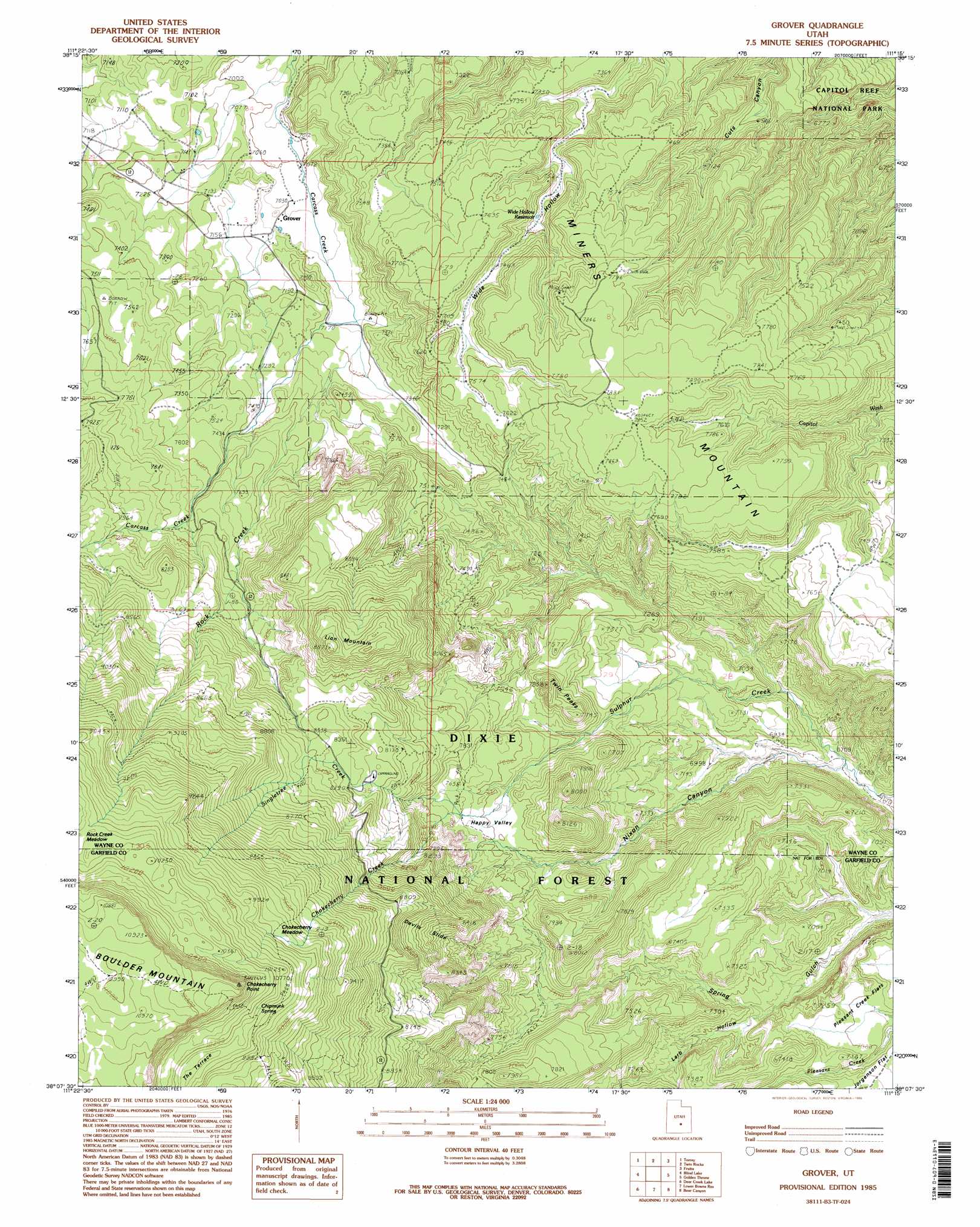
Grover Topo Map Utah
To zoom in, hover over the map of Grover
USGS Topo Quad 38111b3 - 1:24,000 scale
| Topo Map Name: | Grover |
| USGS Topo Quad ID: | 38111b3 |
| Print Size: | ca. 21 1/4" wide x 27" high |
| Southeast Coordinates: | 38.125° N latitude / 111.25° W longitude |
| Map Center Coordinates: | 38.1875° N latitude / 111.3125° W longitude |
| U.S. State: | UT |
| Filename: | o38111b3.jpg |
| Download Map JPG Image: | Grover topo map 1:24,000 scale |
| Map Type: | Topographic |
| Topo Series: | 7.5´ |
| Map Scale: | 1:24,000 |
| Source of Map Images: | United States Geological Survey (USGS) |
| Alternate Map Versions: |
Notom 3 NE UT 1952, updated 1954 Download PDF Buy paper map Grover UT 1985, updated 1985 Download PDF Buy paper map Grover UT 1985, updated 1995 Download PDF Buy paper map Grover UT 2002, updated 2005 Download PDF Buy paper map Grover UT 2011 Download PDF Buy paper map Grover UT 2014 Download PDF Buy paper map |
| FStopo: | US Forest Service topo Grover is available: Download FStopo PDF Download FStopo TIF |
1:24,000 Topo Quads surrounding Grover
Lyman |
Flat Top |
Cathedral Mountain |
Fruita Nw |
Caine Springs |
Bicknell |
Torrey |
Twin Rocks |
Fruita |
Caineville |
Government Point |
Blind Lake |
Grover |
Golden Throne |
Notom |
Jacobs Reservoir |
Deer Creek Lake |
Lower Bowns Reservoir |
Bear Canyon |
Sandy Creek Benches |
Roger Peak |
Boulder Town |
Steep Creek Bench |
Lamp Stand |
Bitter Creek Divide |
> Back to 38111a1 at 1:100,000 scale
> Back to 38110a1 at 1:250,000 scale
> Back to U.S. Topo Maps home
Grover topo map: Gazetteer
Grover: Basins
Happy Valley elevation 2322m 7618′Grover: Capes
Chokecherry Point elevation 3259m 10692′Grover: Flats
Chokecherry Meadow elevation 2945m 9662′Pleasant Creek Flats elevation 2129m 6984′
Rock Creek Meadow elevation 3074m 10085′
Grover: Populated Places
Grover elevation 2169m 7116′Grover: Ranges
The Three Brothers elevation 2479m 8133′Grover: Reservoirs
Wide Hollow Reservoir elevation 2252m 7388′Grover: Slopes
Devils Slide elevation 2522m 8274′Grover: Springs
Chipmunk Spring elevation 3097m 10160′Grover: Streams
Chokecherry Creek elevation 2378m 7801′Rock Creek elevation 2170m 7119′
Singletree Creek elevation 2378m 7801′
Grover: Summits
Lion Mountain elevation 2698m 8851′Miners Mountain elevation 2406m 7893′
Twin Peaks elevation 2376m 7795′
Grover: Valleys
Larb Hollow elevation 2110m 6922′Nixon Canyon elevation 2036m 6679′
Grover digital topo map on disk
Buy this Grover topo map showing relief, roads, GPS coordinates and other geographical features, as a high-resolution digital map file on DVD: