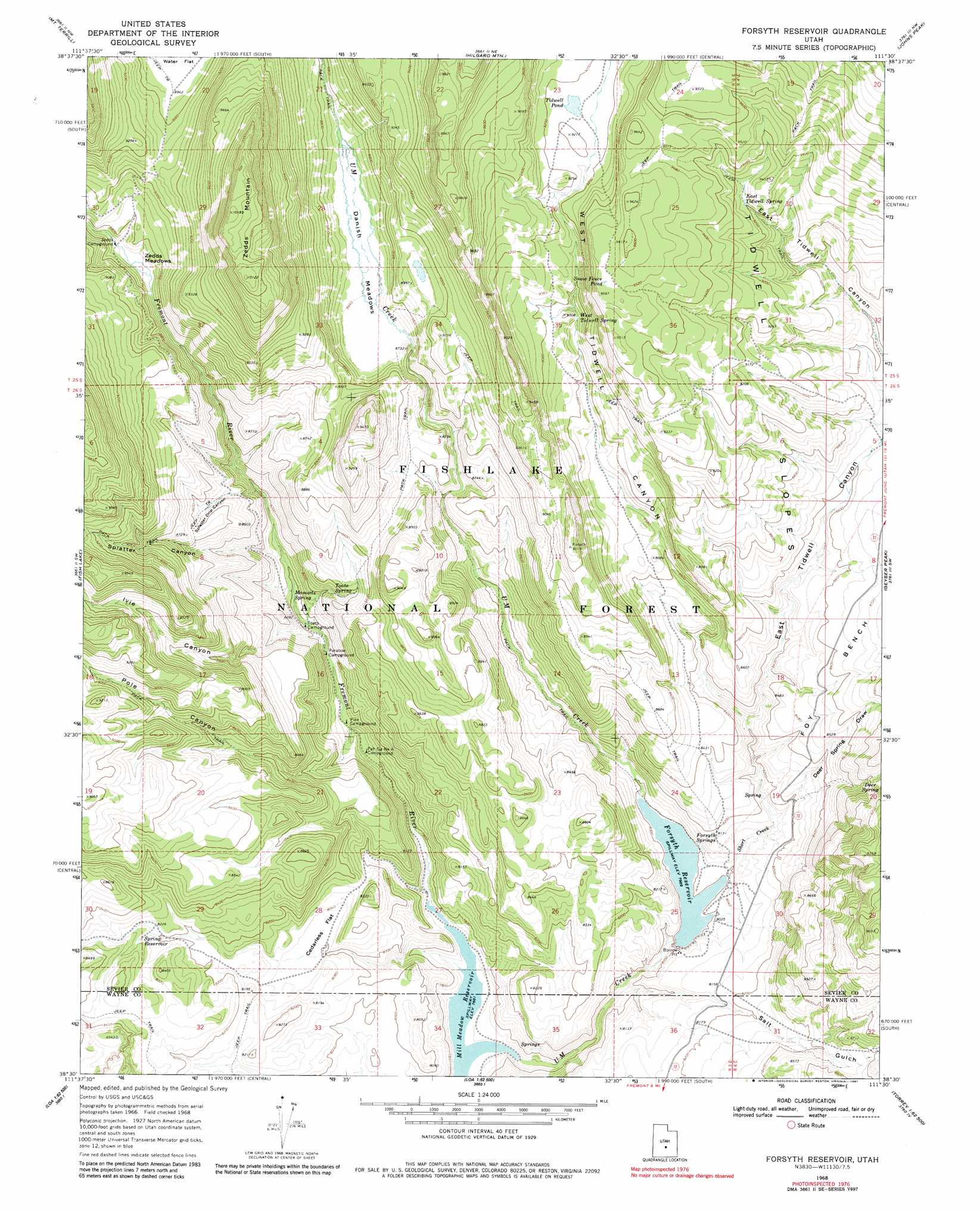
Forsyth Reservoir Topo Map Utah
To zoom in, hover over the map of Forsyth Reservoir
USGS Topo Quad 38111e5 - 1:24,000 scale
| Topo Map Name: | Forsyth Reservoir |
| USGS Topo Quad ID: | 38111e5 |
| Print Size: | ca. 21 1/4" wide x 27" high |
| Southeast Coordinates: | 38.5° N latitude / 111.5° W longitude |
| Map Center Coordinates: | 38.5625° N latitude / 111.5625° W longitude |
| U.S. State: | UT |
| Filename: | o38111e5.jpg |
| Download Map JPG Image: | Forsyth Reservoir topo map 1:24,000 scale |
| Map Type: | Topographic |
| Topo Series: | 7.5´ |
| Map Scale: | 1:24,000 |
| Source of Map Images: | United States Geological Survey (USGS) |
| Alternate Map Versions: |
Forsyth Reservoir UT 1968, updated 1972 Download PDF Buy paper map Forsyth Reservoir UT 1976, updated 1981 Download PDF Buy paper map Forsyth Reservoir UT 2001, updated 2003 Download PDF Buy paper map Forsyth Reservoir UT 2011 Download PDF Buy paper map Forsyth Reservoir UT 2014 Download PDF Buy paper map |
| FStopo: | US Forest Service topo Forsyth Reservoir is available: Download FStopo PDF Download FStopo TIF |
1:24,000 Topo Quads surrounding Forsyth Reservoir
Rex Reservoir |
Gooseberry Creek |
Yogo Creek |
Old Woman Plateau |
Walker Flat |
Boobe Hole Reservoir |
Mount Terrill |
Hilgard Mountain |
Johns Peak |
Willow Springs |
Burrville |
Fish Lake |
Forsyth Reservoir |
Geyser Peak |
Solomons Temple |
Abes Knoll |
Loa |
Lyman |
Flat Top |
Cathedral Mountain |
Jakes Knoll |
Moroni Peak |
Bicknell |
Torrey |
Twin Rocks |
> Back to 38111e1 at 1:100,000 scale
> Back to 38110a1 at 1:250,000 scale
> Back to U.S. Topo Maps home
Forsyth Reservoir topo map: Gazetteer
Forsyth Reservoir: Benches
Foy Bench elevation 2659m 8723′Forsyth Reservoir: Dams
Forsyth Dam elevation 2437m 7995′Forsyth Reservoir: Flats
Cedarless Flat elevation 2444m 8018′Danish Meadows elevation 2640m 8661′
Zedds Meadows elevation 2645m 8677′
Forsyth Reservoir: Lakes
Snow Fence Pond elevation 2908m 9540′Tidwell Pond elevation 2801m 9189′
Forsyth Reservoir: Reservoirs
Forsyth Reservoir elevation 2441m 8008′Mill Meadow Reservoir elevation 2343m 7687′
Spring Reservoir elevation 2513m 8244′
Forsyth Reservoir: Slopes
Tidwell Slopes elevation 2756m 9041′Forsyth Reservoir: Springs
Deer Spring elevation 2698m 8851′East Tidwell Spring elevation 2815m 9235′
Forsyth Springs elevation 2445m 8021′
Mamoits Spring elevation 2441m 8008′
Toats Spring elevation 2508m 8228′
West Tidwell Spring elevation 2697m 8848′
Forsyth Reservoir: Streams
Short Creek elevation 2440m 8005′U M Creek elevation 2347m 7700′
Forsyth Reservoir: Summits
Zedds Mountain elevation 3099m 10167′Forsyth Reservoir: Valleys
Deer Spring Draw elevation 2475m 8120′East Tidwell Canyon elevation 2510m 8234′
Ivie Canyon elevation 2436m 7992′
Pole Canyon elevation 2429m 7969′
Post Hollow elevation 2355m 7726′
Salt Gulch elevation 2400m 7874′
Splatter Canyon elevation 2470m 8103′
Splatter Drip Canyon elevation 2552m 8372′
West Tidwell Canyon elevation 2475m 8120′
Forsyth Reservoir digital topo map on disk
Buy this Forsyth Reservoir topo map showing relief, roads, GPS coordinates and other geographical features, as a high-resolution digital map file on DVD: