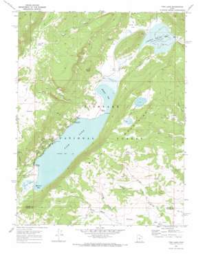
Fish Lake Topo Map Utah
To zoom in, hover over the map of Fish Lake
USGS Topo Quad 38111e6 - 1:24,000 scale
| Topo Map Name: | Fish Lake |
| USGS Topo Quad ID: | 38111e6 |
| Print Size: | ca. 21 1/4" wide x 27" high |
| Southeast Coordinates: | 38.5° N latitude / 111.625° W longitude |
| Map Center Coordinates: | 38.5625° N latitude / 111.6875° W longitude |
| U.S. State: | UT |
| Filename: | o38111e6.jpg |
| Download Map JPG Image: | Fish Lake topo map 1:24,000 scale |
| Map Type: | Topographic |
| Topo Series: | 7.5´ |
| Map Scale: | 1:24,000 |
| Source of Map Images: | United States Geological Survey (USGS) |
| Alternate Map Versions: |
Fish Lake UT 1968, updated 1972 Download PDF Buy paper map Fish Lake UT 1968, updated 1972 Download PDF Buy paper map Fish Lake UT 2001, updated 2003 Download PDF Buy paper map Fish Lake UT 2001, updated 2003 Download PDF Buy paper map Fish Lake UT 2011 Download PDF Buy paper map Fish Lake UT 2014 Download PDF Buy paper map |
| FStopo: | US Forest Service topo Fish Lake is available: Download FStopo PDF Download FStopo TIF |
1:24,000 Topo Quads surrounding Fish Lake
> Back to 38111e1 at 1:100,000 scale
> Back to 38110a1 at 1:250,000 scale
> Back to U.S. Topo Maps home
Fish Lake topo map: Gazetteer
Fish Lake: Areas
Smith Overflow elevation 2702m 8864′Fish Lake: Bays
Mallard Bay elevation 2697m 8848′Widgeon Bay elevation 2697m 8848′
Fish Lake: Capes
Pelican Point elevation 2697m 8848′Fish Lake: Dams
Johnson Valley Dam elevation 2690m 8825′Fish Lake: Flats
Frying Pan Flat elevation 2719m 8920′Fish Lake: Guts
Coots Slough elevation 2699m 8854′Fish Lake: Lakes
Crater Lakes elevation 2900m 9514′Fish Lake elevation 2697m 8848′
Fish Lake: Parks
Bowery Haven Resort elevation 2703m 8868′Twin Creek Picnic Area elevation 2701m 8861′
Fish Lake: Plains
Fish Lake Hightop Plateau elevation 3489m 11446′Fish Lake: Populated Places
Fishlake Resort elevation 2701m 8861′Lakeside Resort elevation 2702m 8864′
Fish Lake: Reservoirs
Johnson Valley Reservoir elevation 2690m 8825′Fish Lake: Springs
Crevice Spring elevation 2691m 8828′Hi Spring elevation 3352m 10997′
Ox Spring elevation 2793m 9163′
Reflection Spring elevation 2692m 8832′
Sidehill Spring elevation 2717m 8914′
Silas Spring elevation 2914m 9560′
Tasha Spring elevation 3472m 11391′
Widgeon Spring elevation 2911m 9550′
Fish Lake: Streams
Anderson Creek elevation 2700m 8858′Bowery Creek elevation 2698m 8851′
Jorgenson Creek elevation 2699m 8854′
Lake Creek elevation 2690m 8825′
Sevenmile Creek elevation 2690m 8825′
Twin Creek elevation 2698m 8851′
Willow Springs elevation 2590m 8497′
Fish Lake: Summits
Mytoge Mountains elevation 3002m 9849′Fish Lake: Valleys
Briggs Hollow elevation 2542m 8339′Doctor Canyon elevation 2708m 8884′
Elias Wells Hollow elevation 2586m 8484′
Nampab Swale elevation 2681m 8795′
Pelican Canyon elevation 2760m 9055′
Porcupine Draw elevation 2695m 8841′
Fish Lake digital topo map on disk
Buy this Fish Lake topo map showing relief, roads, GPS coordinates and other geographical features, as a high-resolution digital map file on DVD:


