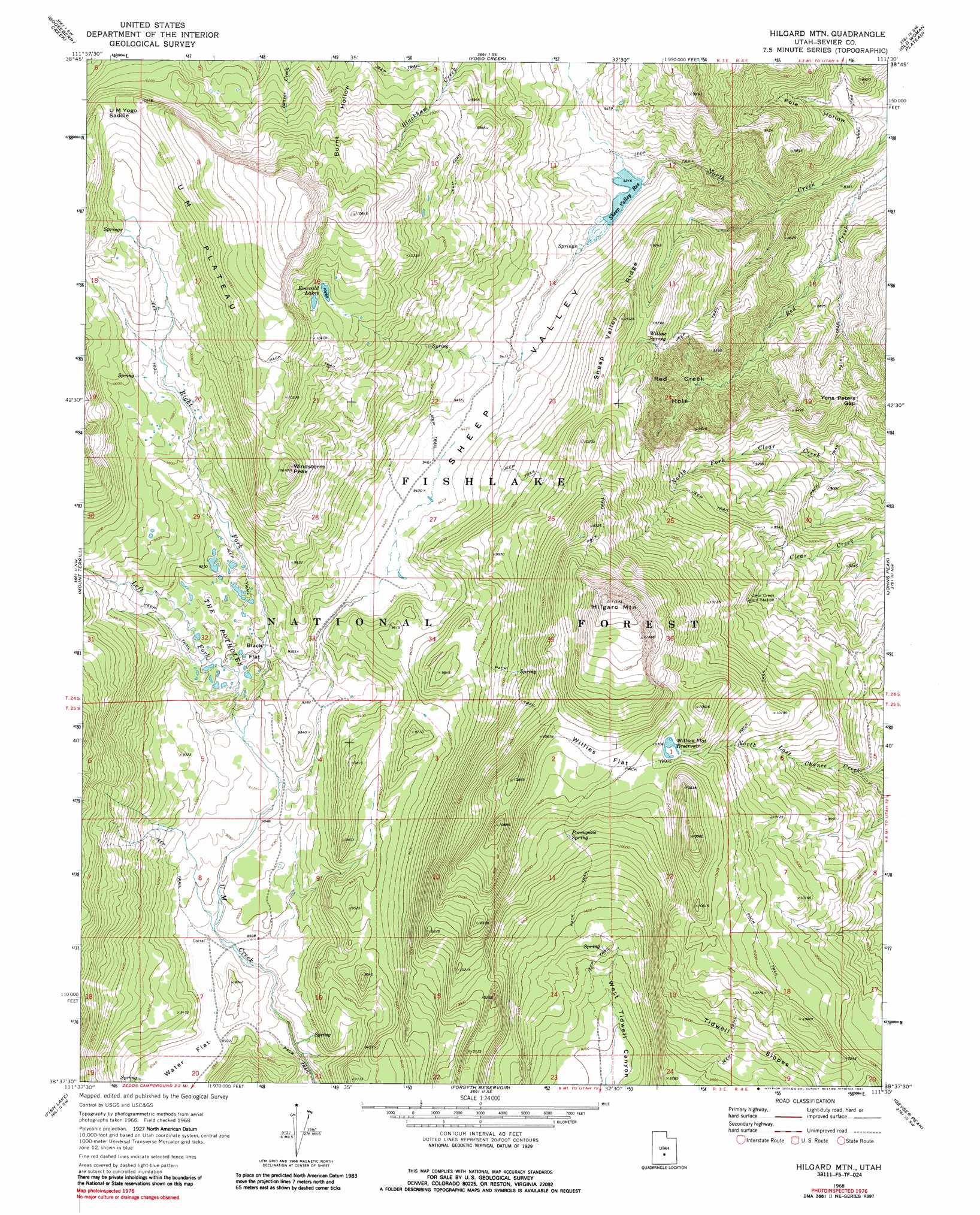
Hilgard Mountain Topo Map Utah
To zoom in, hover over the map of Hilgard Mountain
USGS Topo Quad 38111f5 - 1:24,000 scale
| Topo Map Name: | Hilgard Mountain |
| USGS Topo Quad ID: | 38111f5 |
| Print Size: | ca. 21 1/4" wide x 27" high |
| Southeast Coordinates: | 38.625° N latitude / 111.5° W longitude |
| Map Center Coordinates: | 38.6875° N latitude / 111.5625° W longitude |
| U.S. State: | UT |
| Filename: | o38111f5.jpg |
| Download Map JPG Image: | Hilgard Mountain topo map 1:24,000 scale |
| Map Type: | Topographic |
| Topo Series: | 7.5´ |
| Map Scale: | 1:24,000 |
| Source of Map Images: | United States Geological Survey (USGS) |
| Alternate Map Versions: |
Hilgard Mtn UT 1968, updated 1972 Download PDF Buy paper map Hilgard Mtn UT 1968, updated 1987 Download PDF Buy paper map Hilgard Mountain UT 2001, updated 2003 Download PDF Buy paper map Hilgard Mountain UT 2011 Download PDF Buy paper map Hilgard Mountain UT 2014 Download PDF Buy paper map |
| FStopo: | US Forest Service topo Hilgard Mountain is available: Download FStopo PDF Download FStopo TIF |
1:24,000 Topo Quads surrounding Hilgard Mountain
Salina |
Steves Mountain |
Water Hollow Ridge |
Acord Lakes |
Emery West |
Rex Reservoir |
Gooseberry Creek |
Yogo Creek |
Old Woman Plateau |
Walker Flat |
Boobe Hole Reservoir |
Mount Terrill |
Hilgard Mountain |
Johns Peak |
Willow Springs |
Burrville |
Fish Lake |
Forsyth Reservoir |
Geyser Peak |
Solomons Temple |
Abes Knoll |
Loa |
Lyman |
Flat Top |
Cathedral Mountain |
> Back to 38111e1 at 1:100,000 scale
> Back to 38110a1 at 1:250,000 scale
> Back to U.S. Topo Maps home
Hilgard Mountain topo map: Gazetteer
Hilgard Mountain: Basins
Red Creek Hole elevation 2725m 8940′Hilgard Mountain: Dams
Sheep Valley Dam elevation 2807m 9209′Hilgard Mountain: Flats
Black Flat elevation 2869m 9412′Water Flat elevation 2724m 8937′
Willies Flat elevation 3204m 10511′
Hilgard Mountain: Gaps
U M Yogo Saddle elevation 3167m 10390′Yens Peters Gap elevation 2780m 9120′
Hilgard Mountain: Lakes
Emerald Lakes elevation 3132m 10275′The Potholes elevation 2878m 9442′
Hilgard Mountain: Plains
U M Plateau elevation 3238m 10623′Hilgard Mountain: Reservoirs
Sheep Valley Reservoir elevation 2807m 9209′Willies Flat Reservoir elevation 3141m 10305′
Hilgard Mountain: Ridges
Sheep Valley Ridge elevation 3051m 10009′Hilgard Mountain: Springs
Porcupine Spring elevation 3090m 10137′Willow Spring elevation 2934m 9625′
Hilgard Mountain: Streams
Left Fork U M Creek elevation 2785m 9137′Right Fork U M Creek elevation 2785m 9137′
Hilgard Mountain: Summits
Hilgard Mountain elevation 3519m 11545′Windstorm Peak elevation 3235m 10613′
Hilgard Mountain: Trails
Great Western Trail elevation 2904m 9527′Hilgard Mountain: Valleys
Pole Hollow elevation 2449m 8034′Sheep Valley elevation 2803m 9196′
Hilgard Mountain digital topo map on disk
Buy this Hilgard Mountain topo map showing relief, roads, GPS coordinates and other geographical features, as a high-resolution digital map file on DVD: