Water Hollow Ridge Topo Map Utah
To zoom in, hover over the map of Water Hollow Ridge
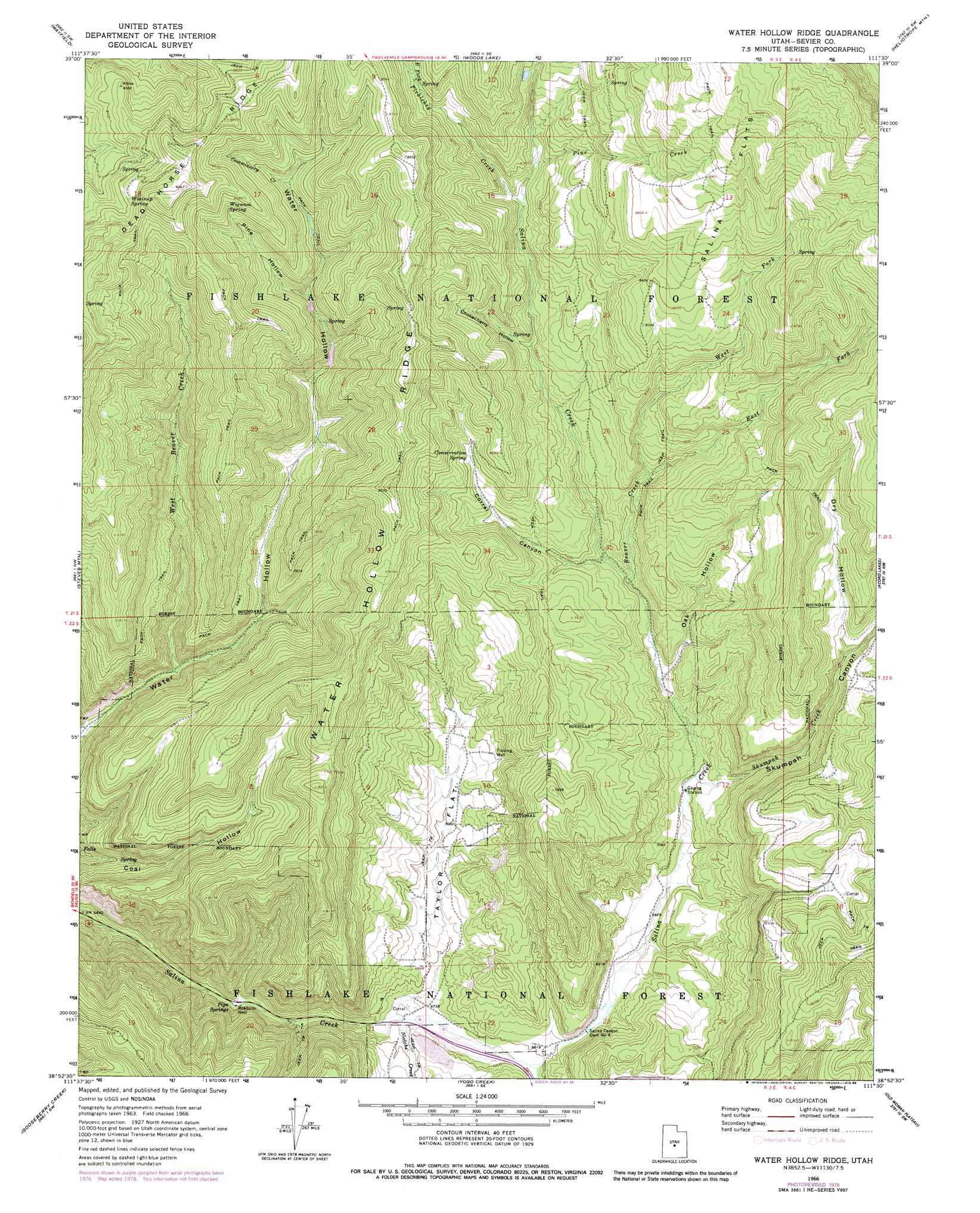
USGS Topo Quad 38111h5 - 1:24,000 scale
| Topo Map Name: | Water Hollow Ridge |
| USGS Topo Quad ID: | 38111h5 |
| Print Size: | ca. 21 1/4" wide x 27" high |
| Southeast Coordinates: | 38.875° N latitude / 111.5° W longitude |
| Map Center Coordinates: | 38.9375° N latitude / 111.5625° W longitude |
| U.S. State: | UT |
| Filename: | o38111h5.jpg |
| Download Map JPG Image: | Water Hollow Ridge topo map 1:24,000 scale |
| Map Type: | Topographic |
| Topo Series: | 7.5´ |
| Map Scale: | 1:24,000 |
| Source of Map Images: | United States Geological Survey (USGS) |
| Alternate Map Versions: |
Water Hollow Ridge UT 1966, updated 1968 Download PDF Buy paper map Water Hollow Ridge UT 1966, updated 1985 Download PDF Buy paper map Water Hollow Ridge UT 2001, updated 2003 Download PDF Buy paper map Water Hollow Ridge UT 2011 Download PDF Buy paper map Water Hollow Ridge UT 2014 Download PDF Buy paper map |
| FStopo: | US Forest Service topo Water Hollow Ridge is available: Download FStopo PDF Download FStopo TIF |
1:24,000 Topo Quads surrounding Water Hollow Ridge
Gunnison |
Sterling |
Black Mountain |
Ferron Reservoir |
Ferron Canyon |
Redmond |
Mayfield |
Woods Lake |
Heliotrope Mountain |
Flagstaff Peak |
Salina |
Steves Mountain |
Water Hollow Ridge |
Acord Lakes |
Emery West |
Rex Reservoir |
Gooseberry Creek |
Yogo Creek |
Old Woman Plateau |
Walker Flat |
Boobe Hole Reservoir |
Mount Terrill |
Hilgard Mountain |
Johns Peak |
Willow Springs |
> Back to 38111e1 at 1:100,000 scale
> Back to 38110a1 at 1:250,000 scale
> Back to U.S. Topo Maps home
Water Hollow Ridge topo map: Gazetteer
Water Hollow Ridge: Dams
Salina Canyon Dam Number 4 elevation 2086m 6843′Water Hollow Ridge: Flats
Salina Flats elevation 2869m 9412′Taylor Flat elevation 2122m 6961′
Water Hollow Ridge: Ridges
Dead Horse Ridge elevation 2668m 8753′Water Hollow Ridge elevation 2508m 8228′
Water Hollow Ridge: Springs
Conservation Spring elevation 2382m 7814′Pipe Springs elevation 2013m 6604′
Wigwam Spring elevation 2584m 8477′
Wikieup Spring elevation 2641m 8664′
Water Hollow Ridge: Streams
Beaver Creek elevation 2195m 7201′Commissary Creek elevation 2448m 8031′
East Fork Beaver Creek elevation 2283m 7490′
East Fork Picklekeg Creek elevation 2500m 8202′
Meadow Creek elevation 2071m 6794′
Niotche Creek elevation 2051m 6729′
Picklekeg Creek elevation 2366m 7762′
Pine Creek elevation 2390m 7841′
Skutumpah Creek elevation 2135m 7004′
West Beaver Creek elevation 2098m 6883′
West Fork Beaver Creek elevation 2283m 7490′
Water Hollow Ridge: Valleys
Chokecherry Hollow elevation 2308m 7572′Corral Canyon elevation 2207m 7240′
Dry Hollow elevation 2321m 7614′
Oak Hollow elevation 2171m 7122′
Pine Hollow elevation 2364m 7755′
Skutumpah Canyon elevation 2135m 7004′
Water Hollow Ridge digital topo map on disk
Buy this Water Hollow Ridge topo map showing relief, roads, GPS coordinates and other geographical features, as a high-resolution digital map file on DVD: