Pine Grove Reservoir Topo Map Utah
To zoom in, hover over the map of Pine Grove Reservoir
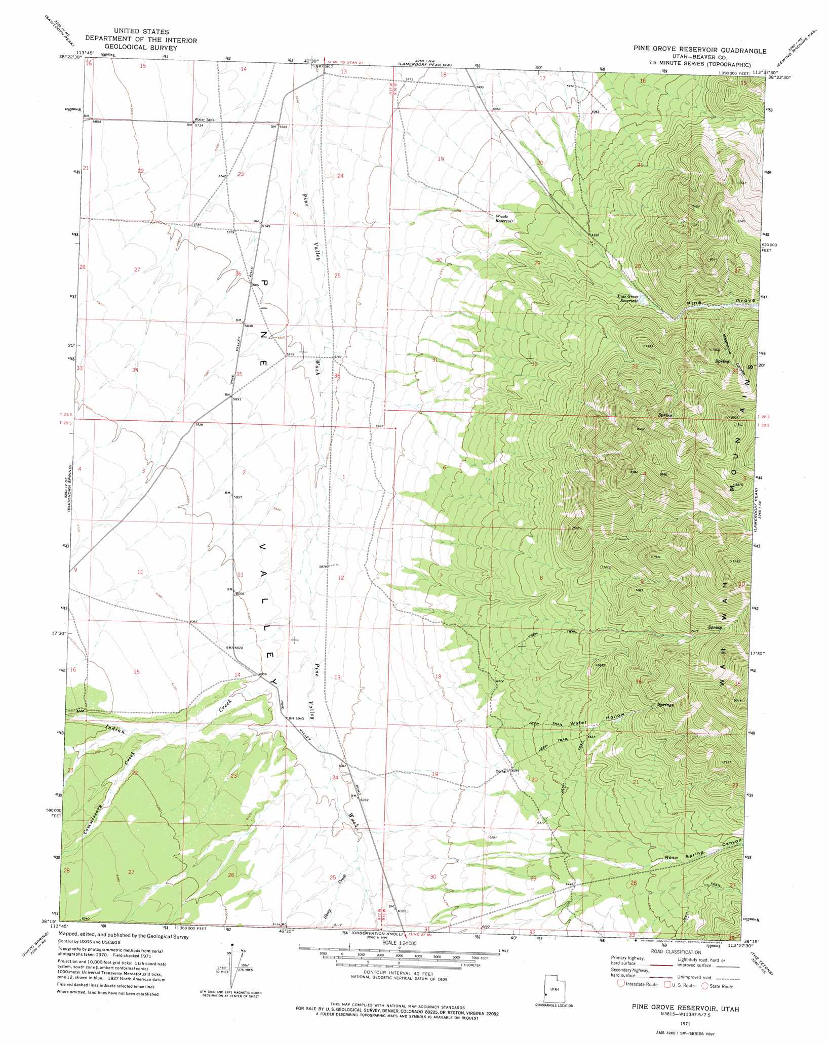
USGS Topo Quad 38113c6 - 1:24,000 scale
| Topo Map Name: | Pine Grove Reservoir |
| USGS Topo Quad ID: | 38113c6 |
| Print Size: | ca. 21 1/4" wide x 27" high |
| Southeast Coordinates: | 38.25° N latitude / 113.625° W longitude |
| Map Center Coordinates: | 38.3125° N latitude / 113.6875° W longitude |
| U.S. State: | UT |
| Filename: | o38113c6.jpg |
| Download Map JPG Image: | Pine Grove Reservoir topo map 1:24,000 scale |
| Map Type: | Topographic |
| Topo Series: | 7.5´ |
| Map Scale: | 1:24,000 |
| Source of Map Images: | United States Geological Survey (USGS) |
| Alternate Map Versions: |
Pine Grove Reservoir UT 1971, updated 1974 Download PDF Buy paper map Pine Grove Reservoir UT 2010 Download PDF Buy paper map Pine Grove Reservoir UT 2014 Download PDF Buy paper map |
1:24,000 Topo Quads surrounding Pine Grove Reservoir
Mountain Home Pass |
Halfway Summit |
Pine Valley Hardpan South |
Wah Wah Summit |
Wah Wah Cove |
Lopers Spring |
Sawtooth Peak |
Lamerdorf Peak Nw |
Sewing Machine Pass |
Wallaces Peak |
Miners Cabin Wash |
Buckhorn Spring |
Pine Grove Reservoir |
Lamerdorf Peak |
Frisco Sw |
Atchison Creek |
Pinto Spring |
Observation Knoll |
The Tetons |
Blue Mountain |
Steamboat Mountain Sw |
Steamboat Mountain |
Bible Spring |
Mountain Spring Peak |
Lund |
> Back to 38113a1 at 1:100,000 scale
> Back to 38112a1 at 1:250,000 scale
> Back to U.S. Topo Maps home
Pine Grove Reservoir topo map: Gazetteer
Pine Grove Reservoir: Reservoirs
Pine Grove Reservoir elevation 1992m 6535′Woods Reservoir elevation 1861m 6105′
Pine Grove Reservoir: Streams
Commissary Creek elevation 1847m 6059′Indian Creek elevation 1799m 5902′
Sheep Creek elevation 1839m 6033′
Pine Grove Reservoir: Valleys
Moonshine Canyon elevation 2106m 6909′Pine Grove elevation 2023m 6637′
Rose Spring Canyon elevation 1957m 6420′
Water Hollow elevation 1922m 6305′
Pine Grove Reservoir digital topo map on disk
Buy this Pine Grove Reservoir topo map showing relief, roads, GPS coordinates and other geographical features, as a high-resolution digital map file on DVD: