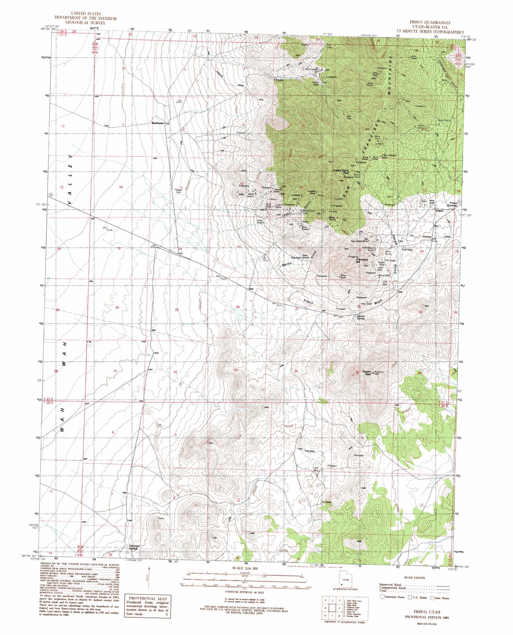
Frisco Topo Map Utah
To zoom in, hover over the map of Frisco
USGS Topo Quad 38113d3 - 1:24,000 scale
| Topo Map Name: | Frisco |
| USGS Topo Quad ID: | 38113d3 |
| Print Size: | ca. 21 1/4" wide x 27" high |
| Southeast Coordinates: | 38.375° N latitude / 113.25° W longitude |
| Map Center Coordinates: | 38.4375° N latitude / 113.3125° W longitude |
| U.S. State: | UT |
| Filename: | o38113d3.jpg |
| Download Map JPG Image: | Frisco topo map 1:24,000 scale |
| Map Type: | Topographic |
| Topo Series: | 7.5´ |
| Map Scale: | 1:24,000 |
| Source of Map Images: | United States Geological Survey (USGS) |
| Alternate Map Versions: |
Frisco UT 1989, updated 1989 Download PDF Buy paper map Frisco UT 2010 Download PDF Buy paper map Frisco UT 2014 Download PDF Buy paper map |
1:24,000 Topo Quads surrounding Frisco
Grassy Cove |
Fifteenmile Point |
Brown Knoll |
Iron Mine Pass |
Red Rock Knoll |
Wah Wah Summit |
Wah Wah Cove |
Frisco Peak |
High Rock |
Lime Mountain |
Sewing Machine Pass |
Wallaces Peak |
Frisco |
Milford Nw |
Milford |
Lamerdorf Peak |
Frisco Sw |
White Mountain |
Picacho Peak |
Milford Flat |
The Tetons |
Blue Mountain |
Burns Knoll |
Thermo |
Ninemile Knoll |
> Back to 38113a1 at 1:100,000 scale
> Back to 38112a1 at 1:250,000 scale
> Back to U.S. Topo Maps home
Frisco topo map: Gazetteer
Frisco: Gaps
Frisco Summit elevation 1973m 6473′Frisco: Mines
Cactus Mine elevation 1936m 6351′Cupric Mine elevation 1898m 6227′
Drum Shaft elevation 1846m 6056′
Frisco Contact Mine elevation 2128m 6981′
Horn Silver Mine elevation 1990m 6528′
Imperial Mine elevation 2087m 6847′
Lulu Mine elevation 1958m 6423′
Old King David Mine elevation 2034m 6673′
Washington Mine elevation 2013m 6604′
Frisco: Populated Places
Frisco elevation 1957m 6420′Newhouse elevation 1570m 5150′
Frisco: Post Offices
Newhouse Post Office (historical) elevation 1569m 5147′Frisco: Springs
Antelope Springs elevation 1689m 5541′Squaw Spring elevation 1825m 5987′
Frisco: Summits
Grampian Hill elevation 2194m 7198′Indian Grave Peak elevation 2237m 7339′
Squaw Peak elevation 2188m 7178′
Frisco: Valleys
Copper Gulch elevation 1711m 5613′Frisco Wash elevation 1645m 5396′
Loeber Gulch elevation 1746m 5728′
Marble Gulch elevation 1682m 5518′
Squaw Gulch elevation 1893m 6210′
Frisco digital topo map on disk
Buy this Frisco topo map showing relief, roads, GPS coordinates and other geographical features, as a high-resolution digital map file on DVD: