Mount Wilson Topo Map Nevada
To zoom in, hover over the map of Mount Wilson
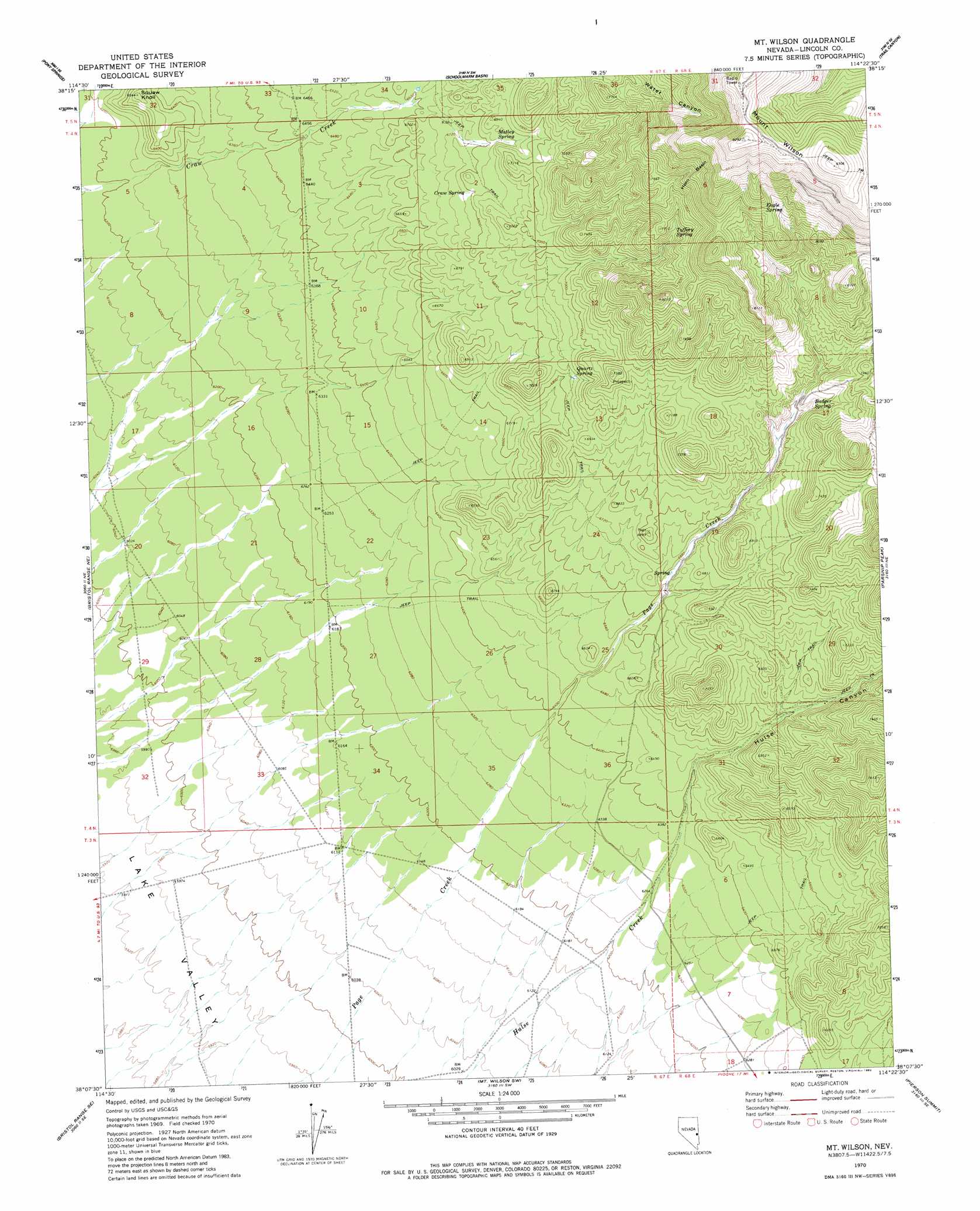
USGS Topo Quad 38114b4 - 1:24,000 scale
| Topo Map Name: | Mount Wilson |
| USGS Topo Quad ID: | 38114b4 |
| Print Size: | ca. 21 1/4" wide x 27" high |
| Southeast Coordinates: | 38.125° N latitude / 114.375° W longitude |
| Map Center Coordinates: | 38.1875° N latitude / 114.4375° W longitude |
| U.S. State: | NV |
| Filename: | o38114b4.jpg |
| Download Map JPG Image: | Mount Wilson topo map 1:24,000 scale |
| Map Type: | Topographic |
| Topo Series: | 7.5´ |
| Map Scale: | 1:24,000 |
| Source of Map Images: | United States Geological Survey (USGS) |
| Alternate Map Versions: |
Mt. Wilson NV 1970, updated 1973 Download PDF Buy paper map Mt. Wilson NV 1970, updated 1982 Download PDF Buy paper map Mount Wilson NV 2012 Download PDF Buy paper map Mount Wilson NV 2014 Download PDF Buy paper map |
1:24,000 Topo Quads surrounding Mount Wilson
Dutch John Mountain |
Mustang Well |
Horse Corral Pass |
Atlanta |
Rosencrans Knolls |
Grassy Mountain |
Pony Springs |
Schoolmarm Basin |
Trail Canyon |
Miller Canyon |
Fairview Peak |
Bristol Range Ne |
Mount Wilson |
Parsnip Peak |
Buck Wash Well |
Bristol Well |
Bristol Range Se |
Mount Wilson Sw |
Pierson Summit |
Eagle Valley Reservoir |
Ely Springs |
Highland Peak |
Pioche |
Rose Valley |
Ursine |
> Back to 38114a1 at 1:100,000 scale
> Back to 38114a1 at 1:250,000 scale
> Back to U.S. Topo Maps home
Mount Wilson topo map: Gazetteer
Mount Wilson: Basins
Horn Basin elevation 2484m 8149′Mount Wilson: Springs
Badger Spring elevation 2156m 7073′Craw Spring elevation 2076m 6811′
Eagle Spring elevation 2495m 8185′
Matley Spring elevation 2099m 6886′
Mountain View Spring elevation 2388m 7834′
Pine Spring elevation 2539m 8330′
Quartz Spring elevation 2107m 6912′
Rock Spring elevation 2314m 7591′
Taffery Spring elevation 2278m 7473′
Mount Wilson: Summits
Mount Wilson elevation 2835m 9301′Squaw Knoll elevation 1991m 6532′
Mount Wilson: Valleys
Hulse Canyon elevation 1939m 6361′Mount Wilson digital topo map on disk
Buy this Mount Wilson topo map showing relief, roads, GPS coordinates and other geographical features, as a high-resolution digital map file on DVD: