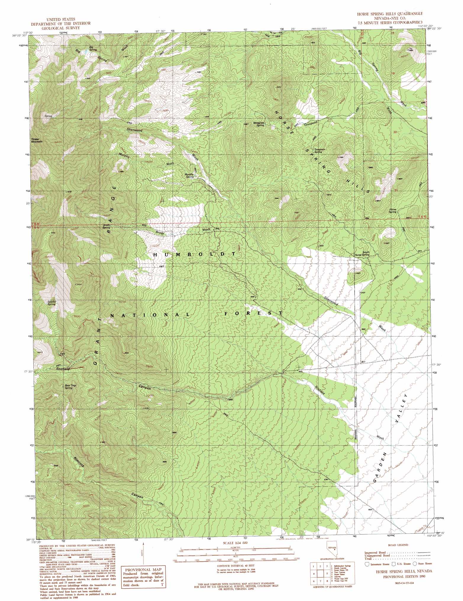
Horse Spring Hills Topo Map Nevada
To zoom in, hover over the map of Horse Spring Hills
USGS Topo Quad 38115c4 - 1:24,000 scale
| Topo Map Name: | Horse Spring Hills |
| USGS Topo Quad ID: | 38115c4 |
| Print Size: | ca. 21 1/4" wide x 27" high |
| Southeast Coordinates: | 38.25° N latitude / 115.375° W longitude |
| Map Center Coordinates: | 38.3125° N latitude / 115.4375° W longitude |
| U.S. State: | NV |
| Filename: | o38115c4.jpg |
| Download Map JPG Image: | Horse Spring Hills topo map 1:24,000 scale |
| Map Type: | Topographic |
| Topo Series: | 7.5´ |
| Map Scale: | 1:24,000 |
| Source of Map Images: | United States Geological Survey (USGS) |
| Alternate Map Versions: |
Horse Spring Hills NV 1990, updated 1990 Download PDF Buy paper map Horse Spring Hills NV 2012 Download PDF Buy paper map Horse Spring Hills NV 2014 Download PDF Buy paper map |
| FStopo: | US Forest Service topo Horse Spring Hills is available: Download FStopo PDF Download FStopo TIF |
1:24,000 Topo Quads surrounding Horse Spring Hills
Blue Eagle Springs Sw |
Blue Eagle Springs |
Blue Eagle Mountain |
Wells Station |
Moorman Spring |
Christian Spring |
Bullwhacker Springs |
Heath Canyon |
Forest Home Ne |
Sunnyside Nw |
Crows Nest |
Troy Canyon |
Horse Spring Hills |
Forest Home |
Hot Creek Butte |
Nyala |
Adaven |
Water Gap Nw |
Water Gap Ne |
Timber Mountain Pass Nw |
Badger Gulch |
Wadsworth Ranch |
Water Gap West |
Water Gap East |
Timber Mountain Pass West |
> Back to 38115a1 at 1:100,000 scale
> Back to 38114a1 at 1:250,000 scale
> Back to U.S. Topo Maps home
Horse Spring Hills topo map: Gazetteer
Horse Spring Hills: Ranges
Horse Spring Hills elevation 2143m 7030′Horse Spring Hills: Springs
Bear Trap Spring elevation 2572m 8438′Big Spring elevation 2459m 8067′
Brady Spring elevation 2571m 8435′
Horse Spring elevation 1903m 6243′
Mountain Spring elevation 1902m 6240′
Murphy Spring elevation 2242m 7355′
Sidehill Spring elevation 2726m 8943′
South Horse Spring elevation 1878m 6161′
Teaspoon Spring elevation 2024m 6640′
Wiregrass Spring elevation 2105m 6906′
Horse Spring Hills: Streams
Brady Wash elevation 2074m 6804′Murphy Wash elevation 2168m 7112′
Horse Spring Hills: Valleys
Scofield Canyon elevation 1889m 6197′Horse Spring Hills digital topo map on disk
Buy this Horse Spring Hills topo map showing relief, roads, GPS coordinates and other geographical features, as a high-resolution digital map file on DVD: