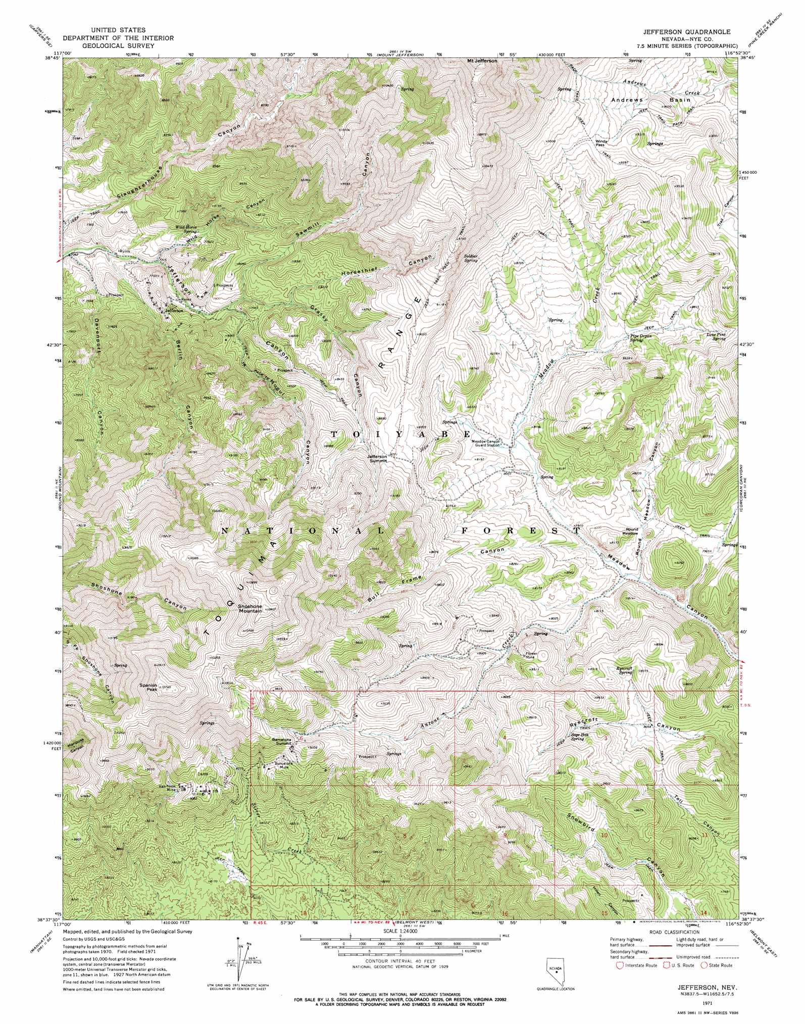
Jefferson Topo Map Nevada
To zoom in, hover over the map of Jefferson
USGS Topo Quad 38116f8 - 1:24,000 scale
| Topo Map Name: | Jefferson |
| USGS Topo Quad ID: | 38116f8 |
| Print Size: | ca. 21 1/4" wide x 27" high |
| Southeast Coordinates: | 38.625° N latitude / 116.875° W longitude |
| Map Center Coordinates: | 38.6875° N latitude / 116.9375° W longitude |
| U.S. State: | NV |
| Filename: | o38116f8.jpg |
| Download Map JPG Image: | Jefferson topo map 1:24,000 scale |
| Map Type: | Topographic |
| Topo Series: | 7.5´ |
| Map Scale: | 1:24,000 |
| Source of Map Images: | United States Geological Survey (USGS) |
| Alternate Map Versions: |
Jefferson NV 1971, updated 1975 Download PDF Buy paper map Jefferson NV 2012 Download PDF Buy paper map Jefferson NV 2014 Download PDF Buy paper map |
| FStopo: | US Forest Service topo Jefferson is available: Download FStopo PDF Download FStopo TIF |
1:24,000 Topo Quads surrounding Jefferson
Carvers Nw |
Carvers Ne |
Jet Spring |
Northumberland Pass |
Box Spring |
Carvers |
Carvers Se |
Mount Jefferson |
Pine Creek Ranch |
Mosquito Creek |
Pablo Canyon Ranch |
Round Mountain |
Jefferson |
Corcoran Canyon |
Barley Creek |
Seyler Peak |
Manhattan |
Belmont West |
Belmont East |
Elkhorn Canyon |
Baxter Spring Nw |
Baxter Spring |
Big Ten Peak West |
Big Ten Peak East |
Mccann Canyon |
> Back to 38116e1 at 1:100,000 scale
> Back to 38116a1 at 1:250,000 scale
> Back to U.S. Topo Maps home
Jefferson topo map: Gazetteer
Jefferson: Basins
Andrews Basin elevation 2696m 8845′Jefferson: Flats
Round Meadow elevation 2401m 7877′Jefferson: Forests
Tonopah Ranger District elevation 2807m 9209′Jefferson: Gaps
Jefferson Summit elevation 2678m 8786′Windy Pass elevation 2823m 9261′
Jefferson: Mines
Barcelona Mine elevation 2728m 8950′Flower Mine elevation 2525m 8284′
Jefferson Mine elevation 2386m 7828′
Prussian Mine elevation 2315m 7595′
Prussian South Mine elevation 2327m 7634′
Van Ness Mine elevation 2725m 8940′
Jefferson: Parks
Meadow Canyon State Game Refuge elevation 2381m 7811′Jefferson: Populated Places
Barcelona (historical) elevation 2728m 8950′Barcelona Summit elevation 2809m 9215′
Flowers Camp elevation 2462m 8077′
Jefferson (historical) elevation 2347m 7700′
San Pedros elevation 2501m 8205′
Van Ness (historical) elevation 2716m 8910′
Jefferson: Post Offices
Jefferson Post Office (historical) elevation 2347m 7700′Jefferson: Springs
Lone Pine Spring elevation 2660m 8727′Pipe Organ Spring elevation 2536m 8320′
Ryecroft Spring elevation 2533m 8310′
Sage Hen Spring elevation 2559m 8395′
Soldier Spring elevation 2725m 8940′
Wild Horse Spring elevation 2357m 7732′
Jefferson: Streams
Antone Creek elevation 2366m 7762′Sawmill Creek elevation 2333m 7654′
Jefferson: Summits
Bull Frame Mountain elevation 3023m 9917′Shoshone Mountain elevation 3322m 10898′
Spanish Peak elevation 3271m 10731′
Three Summits Hill elevation 2734m 8969′
Jefferson: Trails
Austin Belmont Stage Route elevation 2288m 7506′Jefferson: Valleys
Berlin Canyon elevation 2197m 7208′Bull Frame Canyon elevation 2390m 7841′
Davenport Canyon elevation 2159m 7083′
Grassy Canyon elevation 2363m 7752′
Horsethief Canyon elevation 2427m 7962′
Mogul Canyon elevation 2327m 7634′
Round Meadow Canyon elevation 2365m 7759′
Sawmill Canyon elevation 2373m 7785′
Wild Horse Canyon elevation 2250m 7381′
Jefferson digital topo map on disk
Buy this Jefferson topo map showing relief, roads, GPS coordinates and other geographical features, as a high-resolution digital map file on DVD: