Manhattan Topo Map Nevada
To zoom in, hover over the map of Manhattan
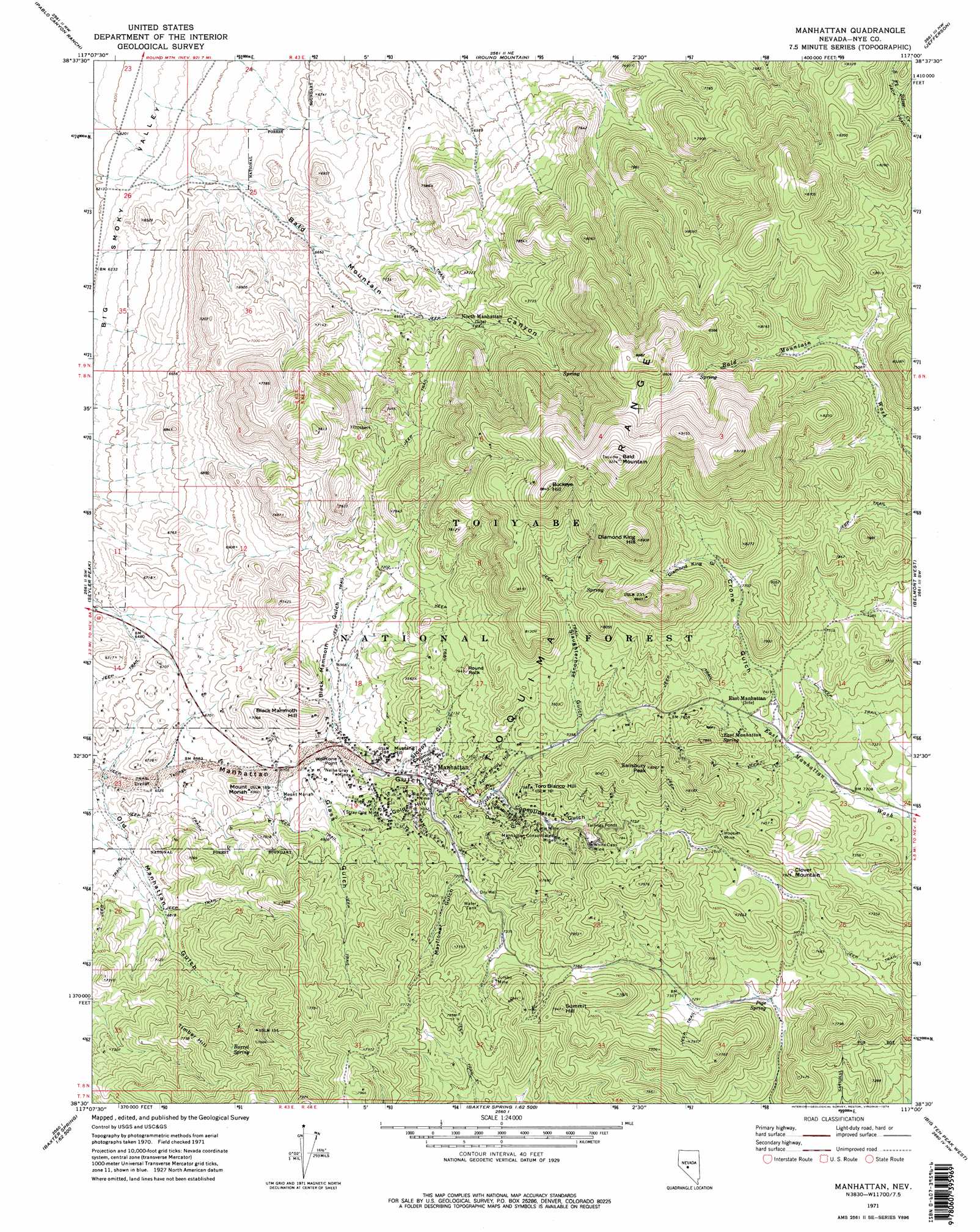
USGS Topo Quad 38117e1 - 1:24,000 scale
| Topo Map Name: | Manhattan |
| USGS Topo Quad ID: | 38117e1 |
| Print Size: | ca. 21 1/4" wide x 27" high |
| Southeast Coordinates: | 38.5° N latitude / 117° W longitude |
| Map Center Coordinates: | 38.5625° N latitude / 117.0625° W longitude |
| U.S. State: | NV |
| Filename: | o38117e1.jpg |
| Download Map JPG Image: | Manhattan topo map 1:24,000 scale |
| Map Type: | Topographic |
| Topo Series: | 7.5´ |
| Map Scale: | 1:24,000 |
| Source of Map Images: | United States Geological Survey (USGS) |
| Alternate Map Versions: |
Manhattan NV 1971, updated 1974 Download PDF Buy paper map Manhattan NV 1971, updated 1974 Download PDF Buy paper map Manhattan NV 2011 Download PDF Buy paper map Manhattan NV 2014 Download PDF Buy paper map |
| FStopo: | US Forest Service topo Manhattan is available: Download FStopo PDF Download FStopo TIF |
1:24,000 Topo Quads surrounding Manhattan
Arc Dome |
Carvers |
Carvers Se |
Mount Jefferson |
Pine Creek Ranch |
Toms Canyon |
Pablo Canyon Ranch |
Round Mountain |
Jefferson |
Corcoran Canyon |
Peavine Ranch |
Seyler Peak |
Manhattan |
Belmont West |
Belmont East |
San Antonio Ranch |
Baxter Spring Nw |
Baxter Spring |
Big Ten Peak West |
Big Ten Peak East |
Liberty Springs |
San Antonio Well |
Henrys Well |
Antelope Spring |
Saulsbury Basin |
> Back to 38117e1 at 1:100,000 scale
> Back to 38116a1 at 1:250,000 scale
> Back to U.S. Topo Maps home
Manhattan topo map: Gazetteer
Manhattan: Capes
Wolftone Point elevation 2109m 6919′Manhattan: Mines
Big Four Mine elevation 2140m 7020′Big Pine Mine elevation 2174m 7132′
Earle Mine elevation 2266m 7434′
Hoosier Mine elevation 2329m 7641′
Jumbo Mine elevation 2292m 7519′
Manhattan Consolidated Mine elevation 2273m 7457′
Nellie Gray Mine elevation 2107m 6912′
Stray Dog Mine elevation 2140m 7020′
White Caps Mine elevation 2325m 7627′
Manhattan: Pillars
Round Rock elevation 2248m 7375′Manhattan: Populated Places
Central (historical) elevation 2011m 6597′Manhattan elevation 2134m 7001′
White Caps (historical) elevation 2316m 7598′
Manhattan: Post Offices
Central Post Office (historical) elevation 2011m 6597′Manhattan Post Office elevation 2134m 7001′
Manhattan: Ridges
April Fool Hill elevation 2234m 7329′Chipmunk Hill elevation 2160m 7086′
Gold Hill elevation 2174m 7132′
Litigation Hill elevation 2213m 7260′
Manhattan: Springs
Barrel Spring elevation 2301m 7549′East Manhattan Spring elevation 2291m 7516′
Pipe Spring elevation 2183m 7162′
Manhattan: Summits
Bald Mountain elevation 2815m 9235′Black Mammoth Hill elevation 2179m 7148′
Buckeye Hill elevation 2678m 8786′
Clover Mountain elevation 2320m 7611′
Diamond King Hill elevation 2700m 8858′
Ferguson Hill elevation 2383m 7818′
Mount Moriah elevation 2115m 6938′
Mustang Hill elevation 2162m 7093′
Salisbury Peak elevation 2527m 8290′
Summit Hill elevation 2418m 7933′
The Bald Brother elevation 2783m 9130′
The Bald Sister elevation 2797m 9176′
Timber Hill elevation 2359m 7739′
Toro Blanco Hill elevation 2294m 7526′
Manhattan: Valleys
Bald Mountain Canyon elevation 1927m 6322′Black Mammoth Gulch elevation 2076m 6811′
Consolidated Gulch elevation 2189m 7181′
Crone Gulch elevation 2245m 7365′
Diamond King Gulch elevation 2374m 7788′
Dublin Gulch elevation 2181m 7155′
Glass Gulch elevation 2070m 6791′
Mayflower Gulch elevation 2195m 7201′
Old Manhattan Gulch elevation 1972m 6469′
Slaughterhouse Gulch elevation 2252m 7388′
Sloppy Gulch elevation 2121m 6958′
Manhattan digital topo map on disk
Buy this Manhattan topo map showing relief, roads, GPS coordinates and other geographical features, as a high-resolution digital map file on DVD: