Round Mountain Topo Map Nevada
To zoom in, hover over the map of Round Mountain
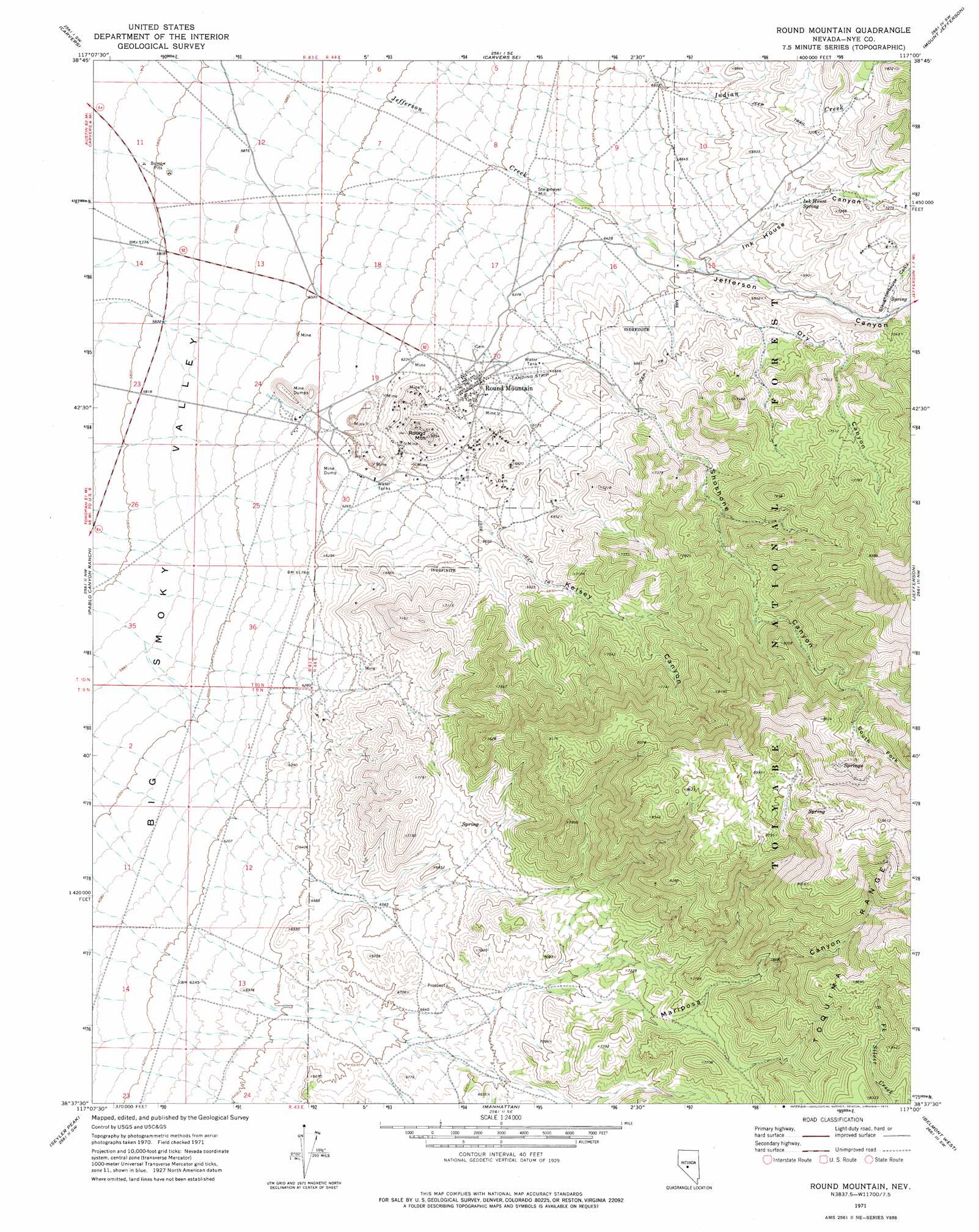
USGS Topo Quad 38117f1 - 1:24,000 scale
| Topo Map Name: | Round Mountain |
| USGS Topo Quad ID: | 38117f1 |
| Print Size: | ca. 21 1/4" wide x 27" high |
| Southeast Coordinates: | 38.625° N latitude / 117° W longitude |
| Map Center Coordinates: | 38.6875° N latitude / 117.0625° W longitude |
| U.S. State: | NV |
| Filename: | o38117f1.jpg |
| Download Map JPG Image: | Round Mountain topo map 1:24,000 scale |
| Map Type: | Topographic |
| Topo Series: | 7.5´ |
| Map Scale: | 1:24,000 |
| Source of Map Images: | United States Geological Survey (USGS) |
| Alternate Map Versions: |
Round Mountain NV 1971, updated 1975 Download PDF Buy paper map Round Mountain NV 2011 Download PDF Buy paper map Round Mountain NV 2014 Download PDF Buy paper map |
| FStopo: | US Forest Service topo Round Mountain is available: Download FStopo PDF Download FStopo TIF |
1:24,000 Topo Quads surrounding Round Mountain
South Toiyabe Peak |
Carvers Nw |
Carvers Ne |
Jet Spring |
Northumberland Pass |
Arc Dome |
Carvers |
Carvers Se |
Mount Jefferson |
Pine Creek Ranch |
Toms Canyon |
Pablo Canyon Ranch |
Round Mountain |
Jefferson |
Corcoran Canyon |
Peavine Ranch |
Seyler Peak |
Manhattan |
Belmont West |
Belmont East |
San Antonio Ranch |
Baxter Spring Nw |
Baxter Spring |
Big Ten Peak West |
Big Ten Peak East |
> Back to 38117e1 at 1:100,000 scale
> Back to 38116a1 at 1:250,000 scale
> Back to U.S. Topo Maps home
Round Mountain topo map: Gazetteer
Round Mountain: Airports
Smoky Valley Mine Landing Strip elevation 1983m 6505′Round Mountain: Mines
Fairview Mine elevation 1988m 6522′Gordon Shaft elevation 1876m 6154′
Great Western Tunnel elevation 1865m 6118′
Number Four Shaft elevation 1874m 6148′
Number Two Shaft elevation 1947m 6387′
Rattlesnake Shaft elevation 2002m 6568′
Red Bird Mine elevation 2543m 8343′
Senator Mine elevation 2701m 8861′
Shamrock Mine elevation 2040m 6692′
Sphinx Glory Hole elevation 1835m 6020′
Sunnyside Shaft elevation 1947m 6387′
Wilson Shaft elevation 1913m 6276′
Round Mountain: Populated Places
Round Mountain elevation 1948m 6391′Steigmeyer Mill elevation 1914m 6279′
Round Mountain: Post Offices
Round Mountain Post Office elevation 1948m 6391′Round Mountain: Springs
Ink House Spring elevation 2111m 6925′Round Mountain: Streams
Mariposa Creek elevation 1860m 6102′Shoshone Creek elevation 1901m 6236′
South Fork Shoshone Creek elevation 2449m 8034′
Round Mountain: Summits
Round Mountain elevation 2083m 6833′Round Mountain: Valleys
Captured Canyon elevation 2220m 7283′Dry Canyon elevation 1968m 6456′
Ink House Canyon elevation 2011m 6597′
Jefferson Canyon elevation 1952m 6404′
Kelsey Canyon elevation 1938m 6358′
Little Dry Canyon elevation 2082m 6830′
Mariposa Canyon elevation 2013m 6604′
Shoshone Canyon elevation 2006m 6581′
Slaughterhouse Canyon elevation 2131m 6991′
South Fork Shoshone Canyon elevation 2463m 8080′
Round Mountain digital topo map on disk
Buy this Round Mountain topo map showing relief, roads, GPS coordinates and other geographical features, as a high-resolution digital map file on DVD: