Grantsville Topo Map Nevada
To zoom in, hover over the map of Grantsville
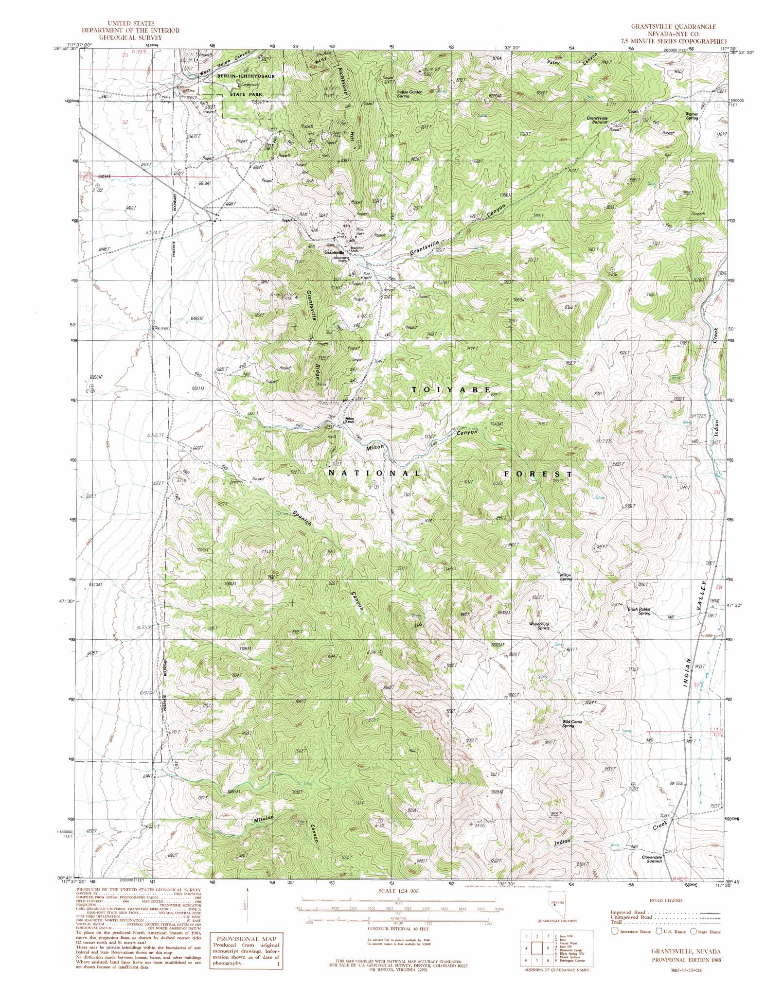
USGS Topo Quad 38117g5 - 1:24,000 scale
| Topo Map Name: | Grantsville |
| USGS Topo Quad ID: | 38117g5 |
| Print Size: | ca. 21 1/4" wide x 27" high |
| Southeast Coordinates: | 38.75° N latitude / 117.5° W longitude |
| Map Center Coordinates: | 38.8125° N latitude / 117.5625° W longitude |
| U.S. State: | NV |
| Filename: | o38117g5.jpg |
| Download Map JPG Image: | Grantsville topo map 1:24,000 scale |
| Map Type: | Topographic |
| Topo Series: | 7.5´ |
| Map Scale: | 1:24,000 |
| Source of Map Images: | United States Geological Survey (USGS) |
| Alternate Map Versions: |
Grantsville NV 1988, updated 1988 Download PDF Buy paper map Grantsville NV 2011 Download PDF Buy paper map Grantsville NV 2014 Download PDF Buy paper map |
| FStopo: | US Forest Service topo Grantsville is available: Download FStopo PDF Download FStopo TIF |
1:24,000 Topo Quads surrounding Grantsville
Burnt Cabin Summit |
Midas Spring |
South Shoshone Peak |
Barrett Canyon |
Tierney Creek |
Ellsworth |
Ione Nw |
Ione |
Corral Wash |
South Toiyabe Peak |
Paradise Peak |
Ione Sw |
Grantsville |
Bakeoven Creek |
Arc Dome |
Goldyke |
Black Spring Nw |
Mount Ardivey |
Farrington Canyon |
Toms Canyon |
Simon |
Black Spring |
Cloverdale Ranch |
Secret Basin |
Peavine Ranch |
> Back to 38117e1 at 1:100,000 scale
> Back to 38116a1 at 1:250,000 scale
> Back to U.S. Topo Maps home
Grantsville topo map: Gazetteer
Grantsville: Gaps
Cloverdale Summit elevation 2346m 7696′Grantsville Summit elevation 2334m 7657′
Grantsville: Mines
Alexander Shafts elevation 2109m 6919′Brooklyn Shaft elevation 2100m 6889′
Centennial Mine elevation 2115m 6938′
Grantsville Mine elevation 2109m 6919′
Milton Canyon Mine elevation 2103m 6899′
Murray Mine elevation 2108m 6916′
San Pedro Mine elevation 2329m 7641′
Grantsville: Parks
Berlin-Ichthyosaur State Park elevation 2126m 6975′Grantsville: Populated Places
Grantsville elevation 2141m 7024′Union elevation 2072m 6797′
Union (historical) elevation 2023m 6637′
Grantsville: Post Offices
Grantsville Post Office (historical) elevation 2141m 7024′Union Post Office (historical) elevation 2072m 6797′
Grantsville: Ridges
Grantsville Ridge elevation 2372m 7782′Grantsville: Springs
Brush Rabbit Spring elevation 2279m 7477′Indian Garden Spring elevation 2349m 7706′
Milton Spring elevation 2388m 7834′
Tremble Spring elevation 2374m 7788′
Warner Spring elevation 2212m 7257′
Wild Carrot Spring elevation 2458m 8064′
Woodchuck Spring elevation 2463m 8080′
Grantsville: Summits
Richmond Hill elevation 2430m 7972′Grantsville: Valleys
Grantsville Canyon elevation 2121m 6958′Milton Canyon elevation 2002m 6568′
Mission Canyon elevation 2066m 6778′
Spanish Canyon elevation 2023m 6637′
West Union Canyon elevation 2033m 6669′
Grantsville digital topo map on disk
Buy this Grantsville topo map showing relief, roads, GPS coordinates and other geographical features, as a high-resolution digital map file on DVD: