Ellsworth Topo Map Nevada
To zoom in, hover over the map of Ellsworth
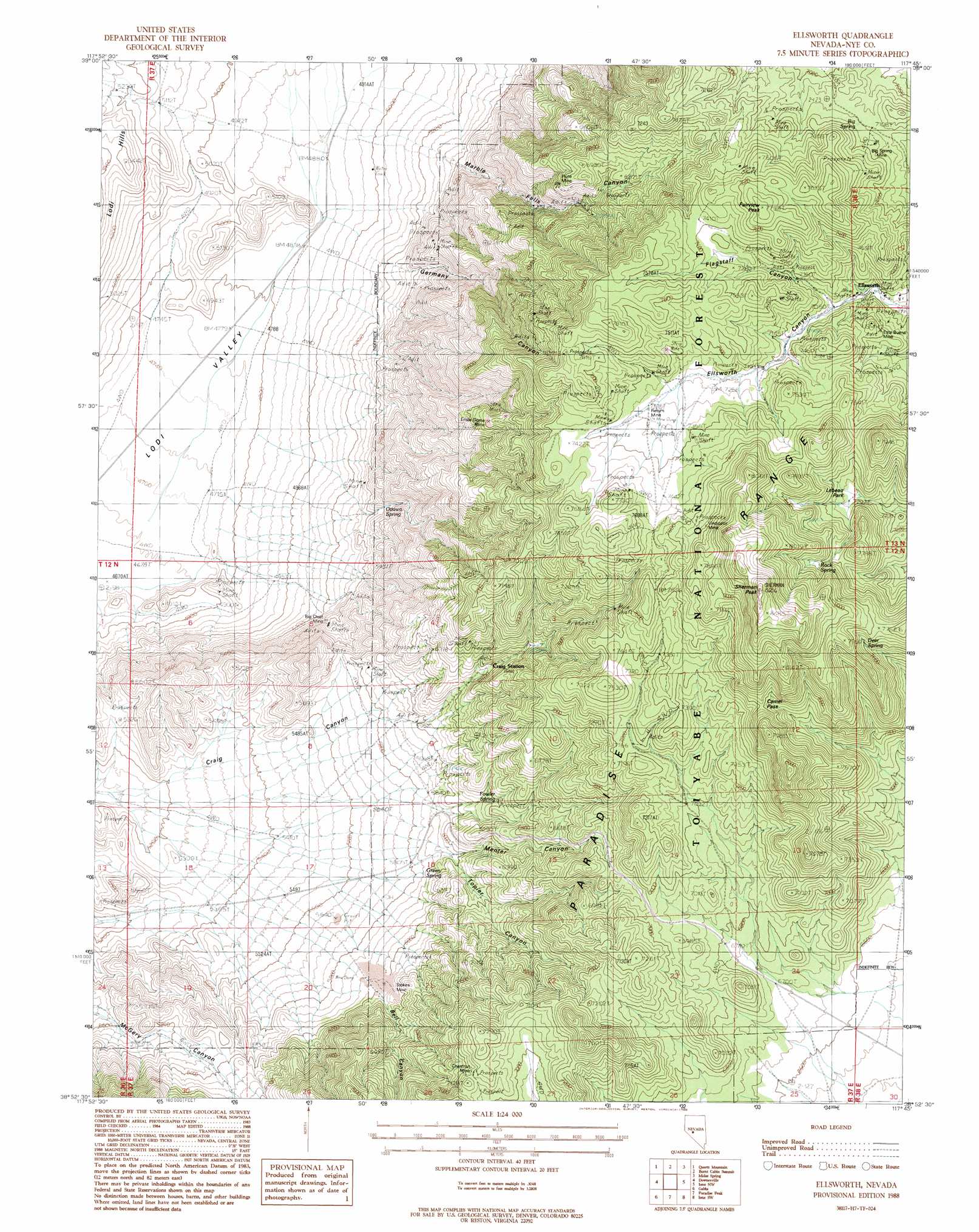
USGS Topo Quad 38117h7 - 1:24,000 scale
| Topo Map Name: | Ellsworth |
| USGS Topo Quad ID: | 38117h7 |
| Print Size: | ca. 21 1/4" wide x 27" high |
| Southeast Coordinates: | 38.875° N latitude / 117.75° W longitude |
| Map Center Coordinates: | 38.9375° N latitude / 117.8125° W longitude |
| U.S. State: | NV |
| Filename: | o38117h7.jpg |
| Download Map JPG Image: | Ellsworth topo map 1:24,000 scale |
| Map Type: | Topographic |
| Topo Series: | 7.5´ |
| Map Scale: | 1:24,000 |
| Source of Map Images: | United States Geological Survey (USGS) |
| Alternate Map Versions: |
Ellsworth NV 1988, updated 1988 Download PDF Buy paper map Ellsworth NV 2011 Download PDF Buy paper map Ellsworth NV 2014 Download PDF Buy paper map |
| FStopo: | US Forest Service topo Ellsworth is available: Download FStopo PDF Download FStopo TIF |
1:24,000 Topo Quads surrounding Ellsworth
Bell Mountain |
Quartz Mountain Nw |
Buffalo Summit |
Campbell Creek Ranch |
Gold Park |
Broken Hills |
Quartz Mountain |
Burnt Cabin Summit |
Midas Spring |
South Shoshone Peak |
Mount Annie Ne |
Downeyville |
Ellsworth |
Ione Nw |
Ione |
Mount Annie Se |
Gabbs |
Paradise Peak |
Ione Sw |
Grantsville |
Gabbs Mountain |
Granny Goose Well |
Goldyke |
Black Spring Nw |
Mount Ardivey |
> Back to 38117e1 at 1:100,000 scale
> Back to 38116a1 at 1:250,000 scale
> Back to U.S. Topo Maps home
Ellsworth topo map: Gazetteer
Ellsworth: Flats
Lebeau Park elevation 2245m 7365′Ellsworth: Gaps
Camel Pass elevation 2322m 7618′Ellsworth: Mines
Big Chief Mine elevation 1611m 5285′Big Spring Mine elevation 2214m 7263′
Chestnut Mine elevation 2138m 7014′
Eary Mine elevation 2248m 7375′
Ensle Dome Mine elevation 2069m 6788′
Esta Buena Mine elevation 2209m 7247′
Piute Mine elevation 2047m 6715′
Return Mine elevation 2234m 7329′
Stokes Mine elevation 1856m 6089′
Vindicator Mine elevation 2362m 7749′
Ellsworth: Populated Places
Ellsworth (historical) elevation 2140m 7020′Green Springs (historical) elevation 1779m 5836′
Lodi Tanks elevation 1523m 4996′
Ellsworth: Post Offices
Ellsworth Post Office (historical) elevation 2140m 7020′Green Springs Post Office (historical) elevation 1779m 5836′
Ellsworth: Ranges
Paradise Range elevation 2091m 6860′Ellsworth: Reservoirs
Lodi Tank elevation 1486m 4875′Ellsworth: Springs
Big Spring elevation 2171m 7122′Camel Spring elevation 2259m 7411′
Deer Spring elevation 2331m 7647′
Fowler Spring elevation 1890m 6200′
Green Spring elevation 1797m 5895′
Ottawa Spring elevation 1667m 5469′
Rock Spring elevation 2467m 8093′
Skunk Spring elevation 1768m 5800′
Ellsworth: Summits
Fairview Peak elevation 2360m 7742′Sherman Peak elevation 2635m 8645′
Ellsworth: Valleys
Bell Canyon elevation 1561m 5121′Flagstaff Canyon elevation 2154m 7066′
Germany Canyon elevation 1634m 5360′
Marble Falls Canyon elevation 1632m 5354′
Menter Canyon elevation 1804m 5918′
Topier Canyon elevation 1842m 6043′
Ellsworth digital topo map on disk
Buy this Ellsworth topo map showing relief, roads, GPS coordinates and other geographical features, as a high-resolution digital map file on DVD: