Bridgeport Topo Map California
To zoom in, hover over the map of Bridgeport
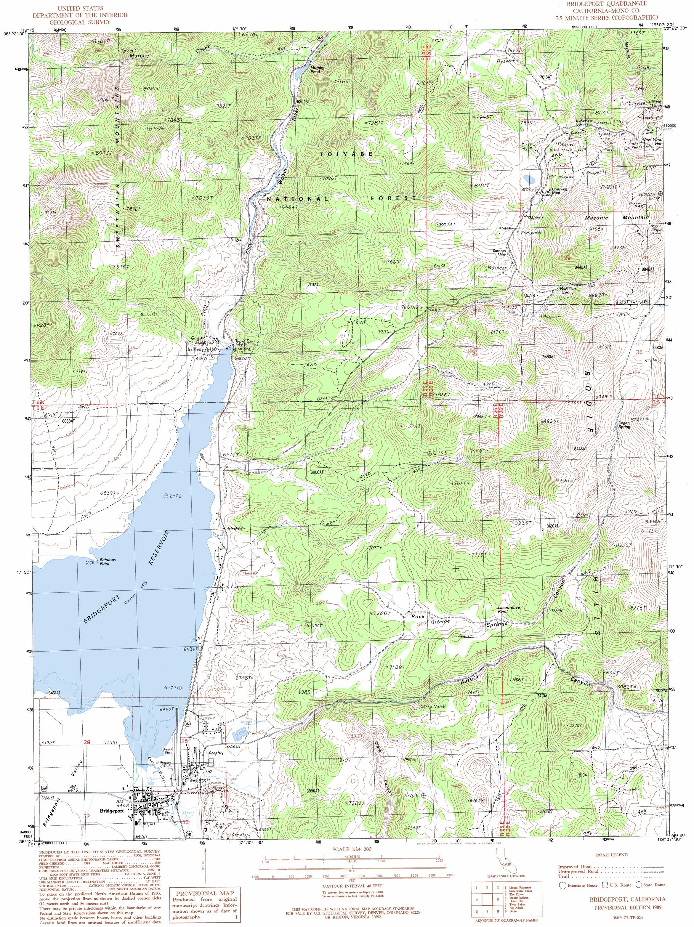
USGS Topo Quad 38119c2 - 1:24,000 scale
| Topo Map Name: | Bridgeport |
| USGS Topo Quad ID: | 38119c2 |
| Print Size: | ca. 21 1/4" wide x 27" high |
| Southeast Coordinates: | 38.25° N latitude / 119.125° W longitude |
| Map Center Coordinates: | 38.3125° N latitude / 119.1875° W longitude |
| U.S. State: | CA |
| Filename: | o38119c2.jpg |
| Download Map JPG Image: | Bridgeport topo map 1:24,000 scale |
| Map Type: | Topographic |
| Topo Series: | 7.5´ |
| Map Scale: | 1:24,000 |
| Source of Map Images: | United States Geological Survey (USGS) |
| Alternate Map Versions: |
Bridgeport CA 1989, updated 1989 Download PDF Buy paper map Bridgeport CA 2012 Download PDF Buy paper map Bridgeport CA 2015 Download PDF Buy paper map |
| FStopo: | US Forest Service topo Bridgeport is available: Download FStopo PDF Download FStopo TIF |
1:24,000 Topo Quads surrounding Bridgeport
Risue Canyon |
Desert Creek Peak |
Nye Canyon |
Wichman Canyon |
Mitchell Spring |
Chris Flat |
Mount Patterson |
Sweetwater Creek |
The Elbow |
Ninemile Ranch |
Fales Hot Springs |
Mount Jackson |
Bridgeport |
Dome Hill |
Aurora |
Buckeye Ridge |
Twin Lakes |
Big Alkali |
Bodie |
Kirkwood Spring |
Matterhorn Peak |
Dunderberg Peak |
Lundy |
Negit Island |
Sulphur Pond |
> Back to 38119a1 at 1:100,000 scale
> Back to 38118a1 at 1:250,000 scale
> Back to U.S. Topo Maps home
Bridgeport topo map: Gazetteer
Bridgeport: Airports
Bryant Field elevation 1972m 6469′Mono General Hospital Heliport elevation 1972m 6469′
Bridgeport: Capes
Rainbow Point elevation 1969m 6459′Bridgeport: Cliffs
Locomotive Point elevation 2316m 7598′Bridgeport: Dams
Bridgeport 70-002 Dam elevation 1963m 6440′Bridgeport: Lakes
Murphy Pond elevation 1928m 6325′Bridgeport: Mines
Chemung Mine elevation 2491m 8172′Serita Mine elevation 2591m 8500′
Success Mine elevation 2398m 7867′
Bridgeport: Populated Places
Bridgeport elevation 1970m 6463′Bridgeport: Post Offices
Bridgeport Post Office elevation 1973m 6473′Bridgeport: Reservoirs
Bridgeport Reservoir elevation 1967m 6453′Bridgeport: Springs
Lakeview Spring elevation 2444m 8018′Logan Spring elevation 2504m 8215′
McMillan Spring elevation 2474m 8116′
Bridgeport: Streams
Murphy Creek elevation 1930m 6332′Bridgeport: Summits
Masonic Mountain elevation 2809m 9215′New York Hill elevation 2629m 8625′
Bridgeport: Valleys
Aurora Canyon elevation 1973m 6473′Bridgeport Valley elevation 1969m 6459′
Clark Canyon elevation 2088m 6850′
Rock Springs Canyon elevation 1970m 6463′
Bridgeport digital topo map on disk
Buy this Bridgeport topo map showing relief, roads, GPS coordinates and other geographical features, as a high-resolution digital map file on DVD: